neco model questions vol1 2020 geography | Essay

Prepare for your exams with neco model questions vol1 questions? Reviewing past/model questions is one of the most effective ways to guarantee a high score. This practice hub features authentic 2020 geography (Essay) questions designed to simulate the real exam environment.

Practice these randomly selected questions to test your readiness.
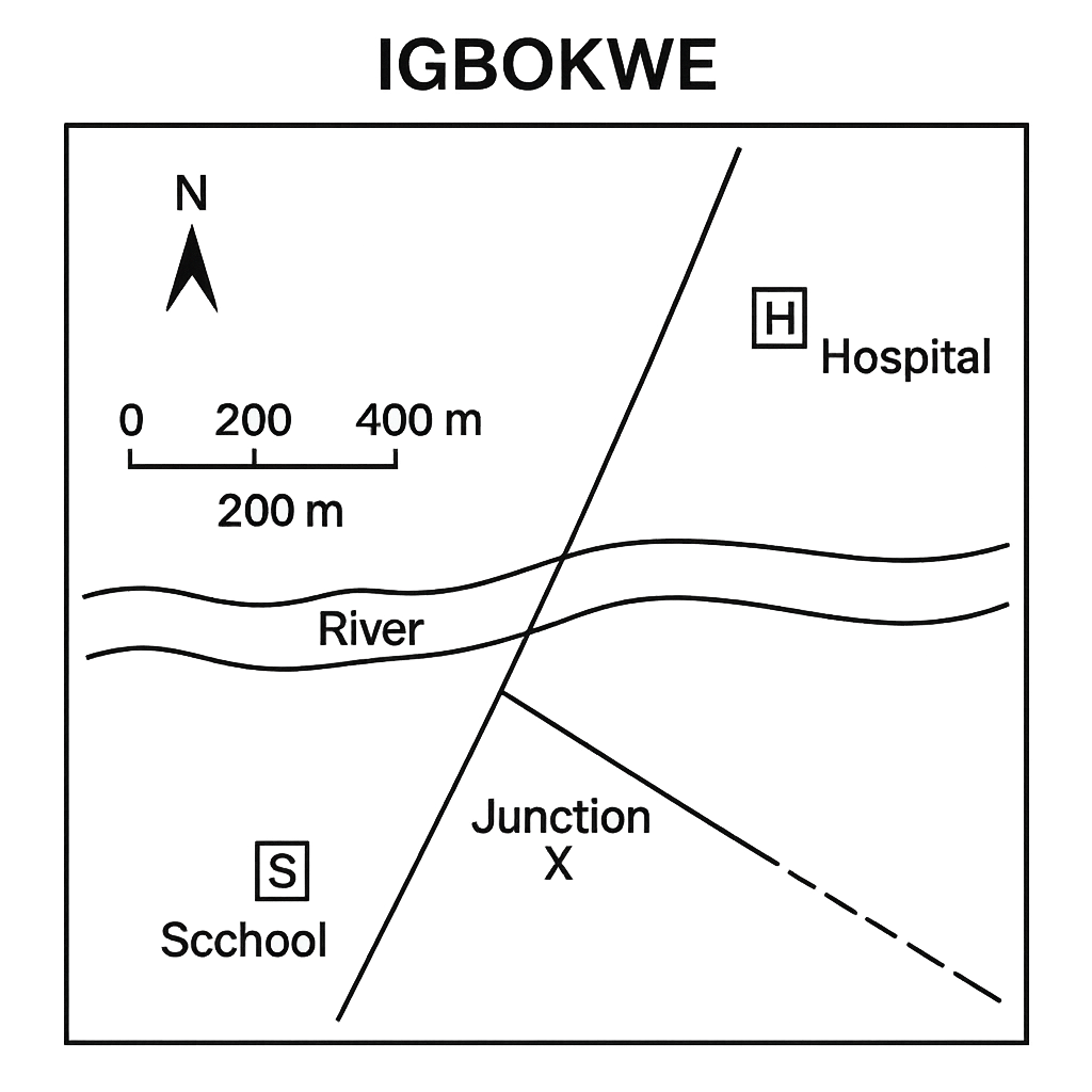
Question 1 View Details
The diagram shows a simplified map of the town of Igbokwe. The map includes a north arrow, a scale bar (1 cm = 200 m) and the following symbols: a school (S), a hospital (H), a river (R) and two roads – Road A (solid line) and Road B (dashed line). On the map the straight‑line distance between the school and the hospital measures 3.5 cm with a ruler. The route that a pedestrian would follow from the school to the hospital along the roads consists of two segments: from the school to the road junction X is 2.0 cm and from X to the hospital is 2.5 cm. The bearing of the line joining the school to the hospital, measured clockwise from the north arrow on the map, is 45°. Answer the following questions:
Question Parts
(a)
State the symbol used on the map to represent the hospital.
(b)
Calculate the actual straight‑line distance between the school and the hospital in metres.
(c)
Estimate the distance a pedestrian would walk from the school to the hospital by following the road route shown on the map.
(d)
State the bearing of the line from the school to the hospital in the standard bearing notation.
Detailed Essay Solution & Marking Scheme Available

Get the step-by-step mathematical proofs, key points required by examiners, and a comprehensive breakdown from our AI Tutor.

Question 2 View Details
The illustration is a map of the Riverine district drawn at a scale of 1 : 50 000 (i.e., 1 cm on the map represents 500 m on the ground). The map shows two towns – Town A and Town B – and a rectangular agricultural plot labelled P. The measured distance on the map between Town A and Town B is 6.0 cm. The plot P is shown as a rectangle with its length measured as 3.0 cm and its width as 2.0 cm on the map. A new road is proposed to run directly from Town A to the centre of plot P. Answer the following:
Question Parts
(a)
Calculate the actual ground distance between Town A and Town B in kilometres.
(b)
A farmer wishes to know how many hectares the rectangular plot P occupies. Determine the area of plot P in hectares.
(c)
If the proposed road from Town A to the centre of plot P is to be built, determine the length of this road in metres. (Assume the centre of the rectangle is exactly at the midpoint of its length and width.)
Detailed Essay Solution & Marking Scheme Available

Get the step-by-step mathematical proofs, key points required by examiners, and a comprehensive breakdown from our AI Tutor.

Question 3 View Details
The city of Kano is situated at approximately 12°00' N latitude and 8°30' E longitude. The town of Zaria lies directly north of Kano on the same longitude, and the distance between the two towns is about 80 km. A new settlement called Malam is located 45 km east of Kano along the same latitude.
Question Parts
(a)
Estimate the difference in latitude between Kano and Zaria in minutes of arc. (Use 1 minute of latitude ≈ 1.852 km.)
(b)
State the initial bearing (azimuth) a traveller should follow when moving from Kano to Zaria.
(c)
Determine the approximate change in longitude between Kano and Malam in minutes of arc. (Use the length of 1 minute of longitude = cos (latitude) × 1.852 km.)
(d)
Discuss two ways in which knowledge of latitude and longitude assists planners in selecting suitable agricultural activities for northern Nigeria.
Detailed Essay Solution & Marking Scheme Available

Get the step-by-step mathematical proofs, key points required by examiners, and a comprehensive breakdown from our AI Tutor.

Question 4 View Details
A weather station in Enugu recorded the following data over a consecutive 7‑day period: Maximum temperatures (°C): 30, 32, 31, 33, 34, 35, 33 Minimum temperatures (°C): 22, 21, 23, 22, 21, 20, 22 Rainfall (mm): 0, 5, 0, 10, 0, 0, 15
Question Parts
(a)
Calculate the mean daily maximum temperature and the mean daily minimum temperature for the week. Show all steps.
(b)
Determine the temperature range (maximum – minimum) for each day and identify the day with the greatest temperature range. Explain a possible reason for this variation.
(c)
Compute the total rainfall for the week and the average rainfall per rainy day. Comment on the distribution pattern of rainfall during the period.
(d)
Using the data above, explain how the concepts of "wet season" and "dry season" can be illustrated, and discuss two implications of this pattern for crop selection in the Enugu region.
Detailed Essay Solution & Marking Scheme Available

Get the step-by-step mathematical proofs, key points required by examiners, and a comprehensive breakdown from our AI Tutor.

Question 5 View Details
The table shows the average monthly maximum temperature (Tmax), minimum temperature (Tmin) in degrees Celsius and total rainfall (R) in millimetres recorded at a coastal town in Nigeria over a 12‑month period. Month | Tmax (°C) | Tmin (°C) | R (mm) --- | --- | --- | --- January | 30 | 22 | 12 February | 31 | 22 | 18 March | 33 | 24 | 45 April | 35 | 26 | 78 May | 36 | 27 | 120 June | 35 | 27 | 210 July | 34 | 26 | 250 August | 34 | 26 | 240 September | 33 | 25 | 180 October | 32 | 24 | 80 November | 31 | 23 | 30 December | 30 | 22 | 15
Question Parts
(a)
Calculate the mean annual temperature of the town. Show all steps.
(b)
Identify the month with the highest rainfall and explain, using the concept of seasonal wind patterns, why the rainfall distribution shows a distinct peak in that month.
(c)
Discuss two major physical factors that influence the climate of this coastal town.
(d)
Using the Köppen climate classification criteria, decide whether the town’s climate is best described as tropical monsoon (Am) or tropical savanna (Aw). Justify your choice with reference to the rainfall data.
Detailed Essay Solution & Marking Scheme Available

Get the step-by-step mathematical proofs, key points required by examiners, and a comprehensive breakdown from our AI Tutor.

Question 6 View Details
A geologist collected a hand specimen of an igneous rock and recorded the following observations: 1. The rock has a coarse‑grained texture. 2. Visible minerals are quartz, feldspar and biotite. 3. The overall colour of the rock is dark grey. 4. It contains phenocrysts of feldspar up to 5 mm in length. 5. The rock exhibits a porphyritic texture (large crystals embedded in a finer‑grained groundmass).
Question Parts
(a)
Identify the rock type and give a brief justification based on the observations.
(b)
Explain the cooling history that produced the observed porphyritic texture.
(c)
Discuss the most likely tectonic setting in which such a rock would form.
(d)
A powdered sample of the rock reacts vigorously with dilute hydrochloric acid, producing bubbles. Explain what this observation reveals about the rock’s mineral composition and how it supports your identification in part (a).
Detailed Essay Solution & Marking Scheme Available

Get the step-by-step mathematical proofs, key points required by examiners, and a comprehensive breakdown from our AI Tutor.

Question 7 View Details
A region in the northern part of Nigeria is characterised by a series of steep, elongated ridges separated by flat valleys, commonly referred to as a cuesta landscape. The area supports limited agriculture and sparse settlements. Answer the following:
Question Parts
(a)
Explain, with reference to geological processes, how a cuesta is formed. Include the role of rock type, dip, and erosion.
(b)
Analyse how the cuesta topography influences the pattern of human settlement, agricultural practice, and transport infrastructure in the region.
(c)
Compare the environmental challenges faced by communities on a cuesta with those on a gently rolling plateau. Suggest two land‑use planning measures that could mitigate the challenges specific to the cuesta.
Detailed Essay Solution & Marking Scheme Available

Get the step-by-step mathematical proofs, key points required by examiners, and a comprehensive breakdown from our AI Tutor.

Question 8 View Details
The Benue River basin in central Nigeria experiences a marked rainy season (June–September) with average monthly rainfall of 250 mm and a dry season with negligible rain. Recent land‑use change has seen extensive clearing of forest on the upper catchment for agriculture. Answer the following:
Question Parts
(a)
Using the given rainfall data, estimate the average annual runoff depth (in mm) from the basin if the runoff coefficient for the forested area is 0.30 and for the cleared agricultural area is 0.55. Assume the basin area is 30 % forested and 70 % cleared.
(b)
Discuss how the conversion of forest to agriculture has altered the river’s discharge regime, particularly focusing on peak flow magnitude and timing during the rainy season.
(c)
Propose two integrated watershed management strategies that could mitigate the adverse effects of increased runoff on downstream communities.
Detailed Essay Solution & Marking Scheme Available

Get the step-by-step mathematical proofs, key points required by examiners, and a comprehensive breakdown from our AI Tutor.

Master the Exam!

You've seen a preview, but there are thousands more questions plus AI tutor to break down complex solutions.

Unlock Full Access Available for Android & Windows
Help others prepare! Share this practice hub:
Chat with Support