neco 2019 geography | Essay

Prepare for your exams with neco questions? Reviewing past/model questions is one of the most effective ways to guarantee a high score. This practice hub features authentic 2019 geography (Essay) questions designed to simulate the real exam environment.

Practice these randomly selected questions to test your readiness.
Question 1 View Details
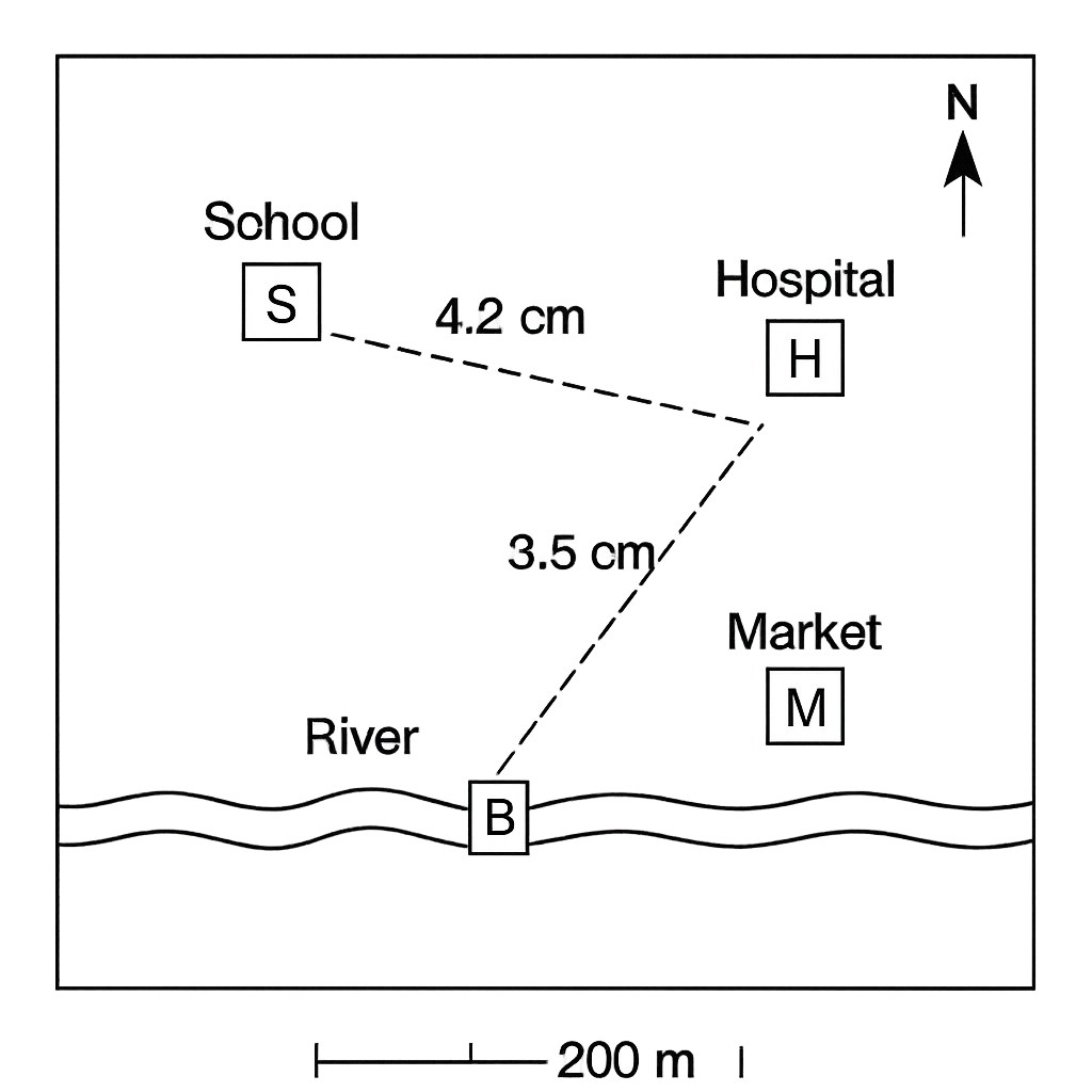
A schematic map of a town is provided. The map scale is 1 cm = 200 metres. The map shows the following landmarks: School (S), Hospital (H), Market (M), River (R) and a Bridge (B). The straight‑line distances measured on the map are: S–H = 4.2 cm, S–M = 3.5 cm, and S–B = 2.0 cm. The compass rose on the map indicates that north is at the top and the River lies directly south of the School.
Question Parts
(a)
Calculate the actual straight‑line distance between the School and the Hospital.
(b)
A pedestrian walks from the School to the Market along the road shown on the map. Determine the actual distance walked.
(c)
State the direction of the River from the School using the compass rose.
(d)
The Bridge is located 2.0 cm north of the School on the map. Find the actual northward distance between the School and the Bridge.
Detailed Essay Solution & Marking Scheme Available

Get the step-by-step mathematical proofs, key points required by examiners, and a comprehensive breakdown from our AI Tutor.
Question 2 View Details
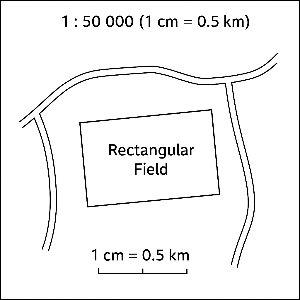
A map of a rural area is drawn at a scale of 1 : 50 000 (i.e., 1 cm on the map represents 0.5 km on the ground). The map shows a rectangular agricultural field. On the map the field measures 6.0 cm in length and 4.0 cm in width. The field is to be used for a new irrigation project.
Question Parts
(a)
Calculate the actual area of the field in hectares.
(b)
A road is to be built diagonally across the field from one corner to the opposite corner. Determine the actual length of this road in kilometres, correct to three decimal places.
(c)
If an irrigation canal is to run along the perimeter of the field, calculate the total length of the canal required in kilometres.
(d)
The map is later reproduced at a larger scale of 1 : 25 000. What will be the new length of the field on the enlarged map (in centimetres)?
Detailed Essay Solution & Marking Scheme Available

Get the step-by-step mathematical proofs, key points required by examiners, and a comprehensive breakdown from our AI Tutor.

Question 3 View Details
A surveyor is stationed at point A whose geographic coordinates are 6°00' N latitude and 5°00' E longitude. From A the surveyor measures a straight‑line distance of 150 km to point B and records the true bearing to B as 120°. Assume the Earth is a sphere with radius 6 371 km and that the distance is short enough to use the plane‑trigonometric approximation for small distances. Answer the following:
Question Parts
(a)
Calculate the latitude of point B (in degrees and minutes).
(b)
Determine the longitude of point B (in degrees and minutes).
(c)
State whether point B lies north or south of the Tropic of Cancer (23°27' N) and justify your answer.
Detailed Essay Solution & Marking Scheme Available

Get the step-by-step mathematical proofs, key points required by examiners, and a comprehensive breakdown from our AI Tutor.

Question 4 View Details
The table below shows the weather observations recorded at the coastal town of Lagos over a consecutive 7‑day period. | Day | Max Temp (°C) | Min Temp (°C) | Rainfall (mm) | Relative Humidity (%) | |-----|---------------|---------------|---------------|-----------------------| | 1 | 33 | 26 | 0 | 68 | | 2 | 31 | 25 | 5 | 72 | | 3 | 30 | 24 | 12 | 78 | | 4 | 28 | 23 | 20 | 84 | | 5 | 27 | 22 | 0 | 70 | | 6 | 29 | 23 | 8 | 75 | | 7 | 32 | 25 | 0 | 69 | Answer the following questions:
Question Parts
(a)
Calculate the mean daily temperature for the 7‑day period. (Mean daily temperature = (Max + Min)/2 for each day, then average over the period.)
(b)
Determine the coefficient of variation (CV) of the daily maximum temperature for the period. Express your answer as a percentage to one decimal place. (CV = (standard deviation / mean) × 100%).
(c)
On day 4 a pressure gradient of 5 hPa from east to west was recorded. Identify the prevailing wind direction on that day and explain how it would influence the weather experienced in Lagos.
(d)
Using the data provided, discuss two possible reasons for the observed pattern of rainfall during the week.
Detailed Essay Solution & Marking Scheme Available

Get the step-by-step mathematical proofs, key points required by examiners, and a comprehensive breakdown from our AI Tutor.

Question 5 View Details
A climatological study was carried out for the city of Jos (latitude 9.9° N, longitude 8.9° E, altitude 1,200 m). The following average monthly data were recorded: - Mean monthly temperature (°C): Jan 22, Feb 23, Mar 24, Apr 25, May 24, Jun 22, Jul 20, Aug 20, Sep 21, Oct 22, Nov 22, Dec 22. - Mean monthly precipitation (mm): Jan 10, Feb 15, Mar 30, Apr 80, May 120, Jun 150, Jul 180, Aug 170, Sep 140, Oct 80, Nov 30, Dec 15. Using this information, answer the following: a) Determine the Köppen climate classification for Jos and justify your answer with reference to the temperature and precipitation thresholds. b) Discuss two major factors that modify the climate of Jos relative to a nearby low‑lying area at sea level. c) Explain how the identified climate type influences agricultural practices in the region, giving two specific examples of crops suitable for this climate.
Question Parts
(a)
Determine the Köppen climate classification for Jos and justify your answer with reference to the temperature and precipitation thresholds.
(b)
Discuss two major factors that modify the climate of Jos relative to a nearby low‑lying area at sea level.
(c)
Explain how the identified climate type influences agricultural practices in the region, giving two specific examples of crops suitable for this climate.
Detailed Essay Solution & Marking Scheme Available

Get the step-by-step mathematical proofs, key points required by examiners, and a comprehensive breakdown from our AI Tutor.

Question 6 View Details
A field geologist examined an outcrop on the northern flank of the Jos Plateau. The following observations were recorded: - The rock is coarse‑grained, visibly crystalline, and composed mainly of quartz, feldspar, and biotite. - The texture is phaneritic with interlocking mineral grains. - The rock exhibits a porphyritic texture where large feldspar phenocrysts are set in a finer groundmass. - No obvious layering or foliation is present. - The outcrop is associated with a network of dykes composed of fine‑grained dark rock. Answer the following: a) Identify the type of rock described and justify your identification using the observed mineralogical and textural features. b) Explain the geological processes that led to the formation of this rock, including the role of magma cooling rate and tectonic setting. c) Discuss two economic uses of this rock type in Nigeria, citing specific examples.
Question Parts
(a)
Identify the type of rock described and justify your identification using the observed mineralogical and textural features.
(b)
Explain the geological processes that led to the formation of this rock, including the role of magma cooling rate and tectonic setting.
(c)
Discuss two economic uses of this rock type in Nigeria, citing specific examples.
Detailed Essay Solution & Marking Scheme Available

Get the step-by-step mathematical proofs, key points required by examiners, and a comprehensive breakdown from our AI Tutor.

Question 7 View Details
The region of Upper Plateau in northern Nigeria exhibits a variety of landforms, including a dissected plateau, an inselberg, a cuesta, and a residual hill. The plateau is composed mainly of Precambrian granite overlain by lateritic soil, while the inselberg consists of a massive granite monolith rising 250 m above the surrounding plain. The cuesta has a gentle dip‑slope of 5° and a steep scarp face. The area receives an average annual rainfall of 1,200 mm, and the vegetation is a mix of savanna grassland and scattered trees.
Question Parts
(a)
Explain the geological processes that led to the formation of each of the four landforms mentioned.
(b)
Discuss how the differences in lithology and structure influence the rates of weathering and erosion of the plateau versus the inselberg.
(c)
Evaluate the potential impacts of expanding agriculture on the stability of the cuesta and the residual hill, and suggest two mitigation measures.
Detailed Essay Solution & Marking Scheme Available

Get the step-by-step mathematical proofs, key points required by examiners, and a comprehensive breakdown from our AI Tutor.

Question 8 View Details
The River Zango drains a catchment area of 3,200 km² in the middle belt of Nigeria. The river originates at an elevation of 1,500 m in the highlands and flows to the Niger River at an elevation of 200 m, covering a length of 120 km. The catchment experiences an average annual rainfall of 1,400 mm, with 60% of the rainfall occurring during the wet season (April–October). The underlying geology consists of alternating layers of sandstone and shale, with the sandstone forming the upper part of the basin. Recent land‑use changes have included extensive deforestation for timber and agriculture.
Question Parts
(a)
Calculate the average gradient of the river in metres per kilometre (m/km) and express it to two decimal places.
(b)
Using the given rainfall data, estimate the total annual volume of water (in cubic metres) contributed by rainfall to the catchment, assuming that 30% of the rainfall becomes direct runoff. Show your working.
Detailed Essay Solution & Marking Scheme Available

Get the step-by-step mathematical proofs, key points required by examiners, and a comprehensive breakdown from our AI Tutor.

Master the Exam!

You've seen a preview, but there are thousands more questions plus AI tutor to break down complex solutions.

Unlock Full Access Available for Android & Windows
Help others prepare! Share this practice hub:
Chat with Support