waec model questions vol1 2024 geography | Essay

Prepare for your exams with waec model questions vol1 questions? Reviewing past/model questions is one of the most effective ways to guarantee a high score. This practice hub features authentic 2024 geography (Essay) questions designed to simulate the real exam environment.

Practice these randomly selected questions to test your readiness.
Question 1 View Details
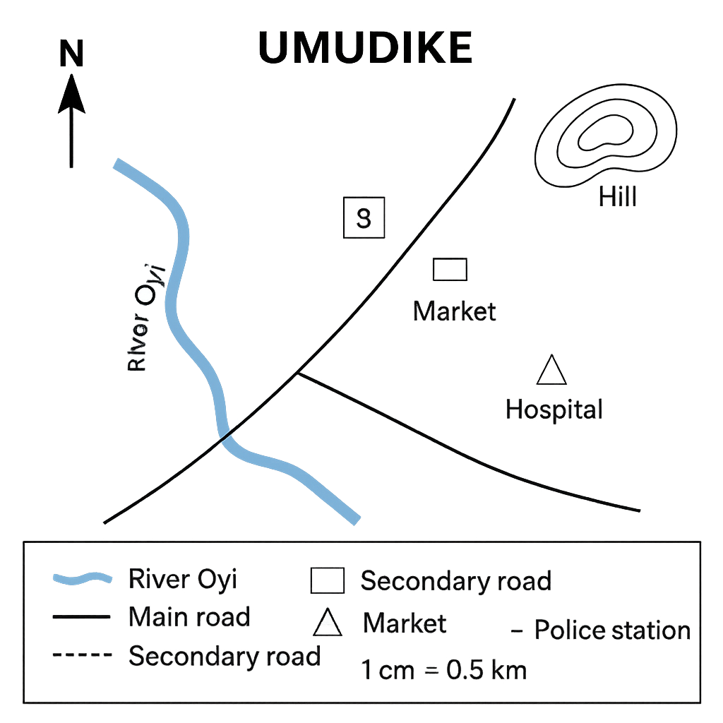
The map of the town of Umudike is shown in the accompanying diagram. The map includes a river, a main road, a secondary road, a school (S), a market (M), a hospital (H), a police station (P) and a hill (Hill). The legend identifies the symbols used. The map scale is 1 cm = 0.5 km.
Question Parts
(a)
Identify the symbol that represents the river on the map and write the name given to the river.
(b)
State the bearing (to the nearest degree) from the school (S) to the market (M).
(c)
The straight‑line distance between the hospital (H) and the police station (P) measures 6 cm on the map. Calculate the actual distance in kilometres.
(d)
Explain two advantages of using a map legend.
Detailed Essay Solution & Marking Scheme Available

Get the step-by-step mathematical proofs, key points required by examiners, and a comprehensive breakdown from our AI Tutor.

Question 2 View Details
The diagram below depicts a coastal area. The map scale is 1 cm = 1 km. Features shown are a beach, a lighthouse (L), a harbour (H), a village (V) and a walking trail (T) marked with a dotted line.
Question Parts
(a)
A straight road between the village (V) and the lighthouse (L) measures 12 km in reality. What length will it occupy on the map (in cm)?
(b)
The walking trail (T) measures 3.5 cm on the map. Determine its actual length in kilometres.
(c)
Explain two reasons why cartographers use different map scales for different purposes.
(d)
Two maps of the same coastal area are available: Map A has a scale of 1:25 000 and Map B has a scale of 1:100 000. Which map provides more detail and why?
Detailed Essay Solution & Marking Scheme Available

Get the step-by-step mathematical proofs, key points required by examiners, and a comprehensive breakdown from our AI Tutor.

Question 3 View Details
Portville, a coastal town, is situated at 5°30' N latitude and 7°15' E longitude. Hilltown lies due north of Portville. On a map with a scale of 1 cm : 10 km, the straight‑line distance between the two settlements measures 12 cm.
Question Parts
(a)
Determine the latitude of Hilltown.
(b)
Using the Earth’s radius of 6371 km, calculate the latitude difference from the great‑circle distance formula and comment on any discrepancy with the result obtained in (a).
Detailed Essay Solution & Marking Scheme Available

Get the step-by-step mathematical proofs, key points required by examiners, and a comprehensive breakdown from our AI Tutor.

Question 4 View Details
The following maximum temperature (°C) and relative humidity (%) readings were recorded at a tropical weather station over a seven‑day period in March: | Day | Temperature (°C) | Relative Humidity (%) | |-----|------------------|-----------------------| | 1 | 30 | 70 | | 2 | 32 | 65 | | 3 | 31 | 80 | | 4 | 33 | 60 | | 5 | 34 | 55 | | 6 | 32 | 75 | | 7 | 31 | 68 | The heat‑index (HI) for each day can be approximated by the formula: HI = T + 0.33·RH – 0.70, where T is temperature in °C and RH is relative humidity in %.
Question Parts
(a)
Calculate the mean daily temperature and the mean relative humidity for the week.
(b)
Compute the heat index for each day using the given formula and state which day experienced the highest heat index.
(c)
Discuss how the interaction of temperature and humidity influences human comfort, referring to the heat‑index values obtained.
Detailed Essay Solution & Marking Scheme Available

Get the step-by-step mathematical proofs, key points required by examiners, and a comprehensive breakdown from our AI Tutor.

Question 5 View Details
The table below shows the average monthly temperature (°C) and average monthly rainfall (mm) recorded at the town of Ikot Ekpene over a 12‑month period. | Month | Temperature (°C) | Rainfall (mm) | |-------|------------------|---------------| | Jan | 27 | 120 | | Feb | 28 | 110 | | Mar | 30 | 90 | | Apr | 31 | 70 | | May | 30 | 50 | | Jun | 28 | 30 | | Jul | 26 | 20 | | Aug | 25 | 25 | | Sep | 26 | 40 | | Oct | 27 | 80 | | Nov | 28 | 100 | | Dec | 27 | 130 | Answer the following questions:
Question Parts
(a)
Calculate the annual mean temperature and the total annual rainfall for Ikot Ekpene.
(b)
Using the Köppen climate‑classification criteria, determine the climate type of Ikot Ekpene. Briefly state the key thresholds you applied.
(c)
Discuss two major implications of this climate (tropical savanna) for agricultural practices in the region.
Detailed Essay Solution & Marking Scheme Available

Get the step-by-step mathematical proofs, key points required by examiners, and a comprehensive breakdown from our AI Tutor.

Question 6 View Details
A geologist studies a rock outcrop on the Jos Plateau and records the following observations: - The rock is coarse‑grained, dark coloured, and exhibits interlocking crystals. - A hand lens reveals visible phenocrysts of feldspar up to 2 mm in length. - The rock is massive with no obvious layering. - Chemical analysis shows the rock contains approximately 55 % silica (SiO₂) by weight. - The region is known for past volcanic activity. Using the information above, answer the following:
Question Parts
(a)
Identify the rock type and justify your identification by referring to at least three of the observed characteristics.
(b)
Explain the geological processes that led to the formation of this rock, linking the process to the tectonic setting of the Jos Plateau.
(c)
The geologist intends to use the rock as a building material. Evaluate its suitability by discussing two physical properties important for construction and how this rock measures up.
Detailed Essay Solution & Marking Scheme Available

Get the step-by-step mathematical proofs, key points required by examiners, and a comprehensive breakdown from our AI Tutor.

Question 7 View Details
Answer the following questions on major Nigerian landforms. For each landform, provide a detailed response to the three sub‑parts.
Question Parts
(a)
Niger Delta
() Identify the dominant geomorphic processes responsible for the formation of the Niger Delta.
() Explain how the underlying geology and tectonic setting influence its present shape.
() Evaluate the socio‑economic implications of the Niger Delta for the surrounding region.
(b)
Jos Plateau
() Identify the dominant geomorphic processes responsible for the formation of the Jos Plateau.
() Explain how the underlying geology and tectonic setting influence its present shape.
() Evaluate the socio‑economic implications of the Jos Plateau for the surrounding region.
(c)
Benue Trough
() Identify the dominant geomorphic processes responsible for the formation of the Benue Trough.
() Explain how the underlying geology and tectonic setting influence its present shape.
() Evaluate the socio‑economic implications of the Benue Trough for the surrounding region.
Detailed Essay Solution & Marking Scheme Available

Get the step-by-step mathematical proofs, key points required by examiners, and a comprehensive breakdown from our AI Tutor.

Question 8 View Details
Answer the following questions on drainage systems in Nigeria. Provide reasoned explanations and, where required, propose appropriate management measures.
Question Parts
(a)
River pattern and modification
() Explain why a dendritic drainage pattern commonly develops on the central Nigerian plateau.
() Identify two geological or geomorphological factors that could modify this dendritic pattern to a trellis pattern, and explain how they operate.
(b)
Urbanisation impacts on Lagos drainage
() Assess the impacts of urbanisation on flood risk, water quality and groundwater recharge in Lagos.
Detailed Essay Solution & Marking Scheme Available

Get the step-by-step mathematical proofs, key points required by examiners, and a comprehensive breakdown from our AI Tutor.

Master the Exam!

You've seen a preview, but there are thousands more questions plus AI tutor to break down complex solutions.

Unlock Full Access Available for Android & Windows
Help others prepare! Share this practice hub:
Chat with Support