waec model questions vol1 2023 geography | Objective

Prepare for your exams with waec model questions vol1 questions? Reviewing past/model questions is one of the most effective ways to guarantee a high score. This practice hub features authentic 2023 geography (Objective) questions designed to simulate the real exam environment.

Practice these randomly selected questions to test your readiness.
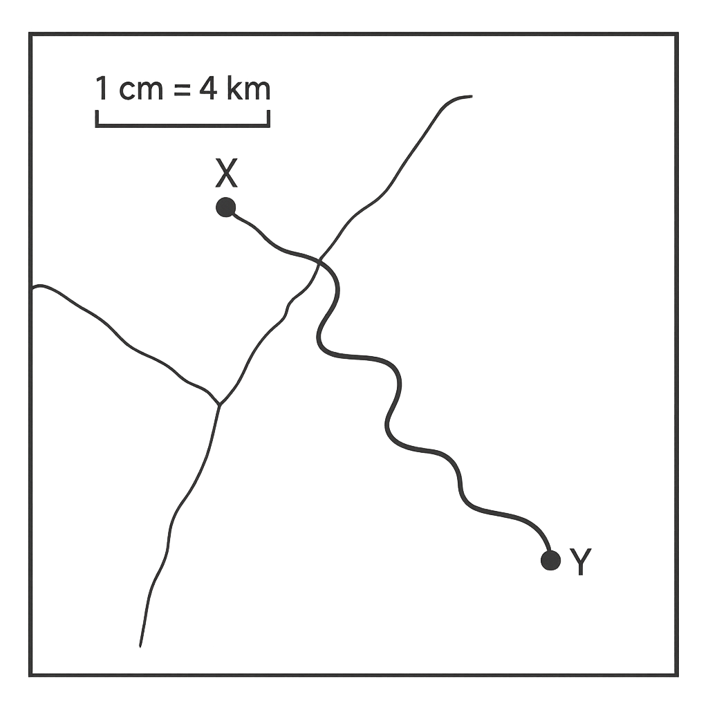
Question 1 View Details
The map shows Town X and Town Y connected by a road. The straight‑line distance between the towns on the map measures 5.6 cm. The road follows the terrain and is 1.2 times longer than the straight line. The map scale is 1 cm : 4 km. Calculate the actual length of the road in kilometres, giving your answer to one decimal place.
A. 22.4 km
Correct B. 26.9 km
C. 24.5 km
D. 30.2 km

Correct Answer: B

Want to see the full step-by-step solution? Unlock AI Explanation & Analytics
Question 2 View Details
A catchment area of 250 km² receives a uniform storm that delivers 120 mm of rain over 6 hours. The runoff coefficient for the basin is 0.6. The downstream river channel can convey a maximum discharge of 1500 m³ s⁻¹. Assuming the runoff hydrograph is triangular with a time to peak equal to the storm duration (6 h) and a total duration (base width) of twice the time to peak, determine whether the peak discharge exceeds the river's capacity. Show all calculations.
A. Yes, the peak discharge is approximately 900 m³ s⁻¹, which exceeds the river capacity of 1500 m³ s⁻¹.
B. No, the peak discharge is approximately 1200 m³ s⁻¹, which is below the river capacity of 1500 m³ s⁻¹.
C. Yes, the peak discharge is approximately 1800 m³ s⁻¹, which exceeds the river capacity of 1500 m³ s⁻¹.
Correct D. No, the peak discharge is approximately 833 m³ s⁻¹, which is below the river capacity of 1500 m³ s⁻¹.

Correct Answer: D

Want to see the full step-by-step solution? Unlock AI Explanation & Analytics
Question 3 View Details
A bus travels a 180 km route that passes through three zones: urban (first 40 km, speed limit 40 km h⁻¹, fuel consumption 0.40 L km⁻¹), suburban (next 80 km, speed limit 80 km h⁻¹, fuel consumption 0.30 L km⁻¹) and highway (last 60 km, speed limit 120 km h⁻¹, fuel consumption 0.25 L km⁻¹). In any zone the driver may choose to travel at 80 % of the speed limit; when this is done the fuel consumption in that zone is reduced by 20 %. The bus must keep total fuel consumption at or below 45 L while minimizing total travel time. Determine whether the driver can travel at the reduced speed in all three zones and, if so, calculate the total travel time in hours (rounded to two decimal places).
Correct A. Yes; total travel time ≈3.13 h
B. Yes; total travel time ≈3.05 h
C. Yes; total travel time ≈3.20 h
D. No; total travel time ≈3.13 h

Correct Answer: A

Want to see the full step-by-step solution? Unlock AI Explanation & Analytics
Question 4 View Details
A soil sample contains 30 % sand, 45 % silt and 25 % clay and has a bulk density of 1.4 g cm⁻³. Field capacity (FC) can be estimated by FC (%) = 0.2 × %sand + 0.3 × %silt + 0.5 × %clay. Calculate the field capacity as a percentage and then determine the amount of water (in litres) held at field capacity in a 15 cm deep soil layer per square metre of ground.
A. 44 L per m²
Correct B. 48 L per m²
C. 52 L per m²
D. 45 L per m²

Correct Answer: B

Want to see the full step-by-step solution? Unlock AI Explanation & Analytics
Question 5 View Details
A 1 km² savanna is surveyed using 20 quadrats, each covering 0.01 km². The average area recorded in each quadrat is 0.006 km² of grassland, 0.003 km² of shrubland and 0.001 km² of tree islands. Estimate the total area (in km²) of each vegetation type in the whole savanna and state the percentage of the savanna occupied by tree islands.
Correct A. Tree islands cover 0.10 km², which is 10 % of the savanna.
B. Tree islands cover 0.08 km², which is 8 % of the savanna.
C. Tree islands cover 0.15 km², which is 15 % of the savanna.
D. Tree islands cover 0.12 km², which is 12 % of the savanna.

Correct Answer: A

Want to see the full step-by-step solution? Unlock AI Explanation & Analytics
Question 6 View Details
A settlement had a population of 12,000 in 2010. The annual natural increase rate is 2.5% (compounded yearly). At the end of 2015 the settlement lost 1,200 people due to out‑migration. From 2016 onward it receives a net in‑migration of 150 persons each year. The land area of the settlement is 8 km². If a population density above 2,000 persons per km² classifies the settlement as a town, otherwise it is a village, determine the classification of the settlement in 2020.
A. Town
B. Hamlet
Correct C. Village
D. Metropolis

Correct Answer: C

Want to see the full step-by-step solution? Unlock AI Explanation & Analytics
Question 7 View Details
In a region the total rock volume is 500 km³. Initially 40% of the volume is igneous, 35% sedimentary and the remainder metamorphic. Over a geological period, 10% of the igneous rock weathers to become new sedimentary rock, while 5% of the original sedimentary rock metamorphoses. After these changes, what are the percentages (to one decimal place) of igneous, sedimentary and metamorphic rocks in the region?
A. Igneous 35.0%, Sedimentary 37.0%, Metamorphic 28.0%
B. Igneous 36.0%, Sedimentary 38.0%, Metamorphic 26.0%
Correct C. Igneous 36.0%, Sedimentary 37.3%, Metamorphic 26.8%
D. Igneous 38.0%, Sedimentary 35.5%, Metamorphic 26.5%

Correct Answer: C

Want to see the full step-by-step solution? Unlock AI Explanation & Analytics
Question 8 View Details
A map uses the scale 1 cm : 250 m. If a road on the map measures 3.6 cm, what is the actual length of the road in kilometres?
A. 1.2 km
Correct B. 0.9 km
C. 0.36 km
D. 0.45 km

Correct Answer: B

Want to see the full step-by-step solution? Unlock AI Explanation & Analytics
Question 9 View Details
A cold front moves directly south at 20 km/h while a warm front moves directly east at 15 km/h. Determine the speed of the resultant movement of the combined front and give its direction as an angle east of south (to one decimal place).
A. 25 km/h at 45.0° east of south
B. 20 km/h at 36.9° east of south
C. 35 km/h at 30.0° east of south
Correct D. 25 km/h at 36.9° east of south

Correct Answer: D

Want to see the full step-by-step solution? Unlock AI Explanation & Analytics
Question 10 View Details
A location has the following average monthly temperatures (°C): Jan 22, Feb 24, Mar 26, Apr 28, May 30, Jun 28, Jul 27, Aug 27, Sep 26, Oct 24, Nov 23, Dec 22. The corresponding average monthly precipitation (mm) is: Jan 80, Feb 70, Mar 60, Apr 50, May 40, Jun 30, Jul 20, Aug 20, Sep 30, Oct 50, Nov 70, Dec 80. Using the Köppen climate classification, determine the climate type of the location (choose among Aw, Cwa, Af).
A. Cwa
B. BWh
C. Af
Correct D. Aw

Correct Answer: D

Want to see the full step-by-step solution? Unlock AI Explanation & Analytics
Question 11 View Details
A region is exposed to three types of environmental hazards: flood, landslide and drought. The average economic loss per event is ₦150 million for flood, ₦80 million for landslide and ₦200 million for drought. The annual probabilities of occurrence are 0.04 for flood, 0.06 for landslide and p for drought. If the total expected annual loss for the region is ₦22 million, what is the probability p of a drought occurring in a year? Express your answer as a decimal.
A. 0.064
Correct B. 0.056
C. 0.046
D. 0.075

Correct Answer: B

Want to see the full step-by-step solution? Unlock AI Explanation & Analytics
Question 12 View Details
A factory's total cost (in thousand Naira) for producing Q units of a widget is given by C = 0.5Q² + 20Q + 500. The marginal cost (MC) is the derivative of C with respect to Q, and the average cost (AC) is C/Q. At what output level Q (to one decimal place) does MC equal AC?
A. 35.2
Correct B. 31.6
C. 40.0
D. 28.4

Correct Answer: B

Want to see the full step-by-step solution? Unlock AI Explanation & Analytics
Question 13 View Details
A town had a population of 120,000 in 2010. Between 2010 and 2020 the natural increase (births minus deaths) contributed an average annual growth rate of 2.5 %. Net migration added a total of 8,000 people over the decade. What was the average annual net migration rate expressed as a percentage of the 2010 population? Give your answer to two decimal places.
Correct A. 0.67
B. 0.57
C. 0.83
D. 0.75

Correct Answer: A

Want to see the full step-by-step solution? Unlock AI Explanation & Analytics
Question 14 View Details
The average monthly rainfall (in millimetres) for a location is: Jan 120, Feb 80, Mar 60, Apr 40, May 20, Jun 10, Jul 5, Aug 5, Sep 15, Oct 30, Nov 70, Dec 110. How many months receive less than 30 mm of rain, and does the location have a distinct dry season (defined as at least three consecutive months with rainfall below 30 mm)? Answer in the form "X months, Yes" or "X months, No".
A. 5 months, Yes
B. 3 months, No
C. 4 months, No
Correct D. 4 months, Yes

Correct Answer: D

Want to see the full step-by-step solution? Unlock AI Explanation & Analytics
Question 15 View Details
A farmer cultivates maize on 5 ha. Yield per hectare (tonnes) depends on nitrogen fertilizer N (kg ha⁻¹) as \(Y = 2 + 0.04N - 0.0005N^{2}\). The farmer may apply at most 150 kg ha⁻¹ of nitrogen. Maize sells for ₦30,000 per tonne and nitrogen costs ₦120 per kg. Determine the amount of nitrogen (kg ha⁻¹) that maximizes net profit per hectare and compute the maximum net profit per hectare in thousand Naira. Give your answer as "N kg/ha, profit" (profit rounded to two decimal places).
A. 40 kg/ha, 79.20
B. 45 kg/ha, 78.23
C. 30 kg/ha, 78.90
Correct D. 36 kg/ha, 79.44

Correct Answer: D

Want to see the full step-by-step solution? Unlock AI Explanation & Analytics
Question 16 View Details
A town had a population of 150,000 in 2010. It grew at an annual rate of 2.5% for the first five years and then at 1.2% per year thereafter. In which calendar year will the population first exceed 200,000?
A. 2027
Correct B. 2029
C. 2030
D. 2028

Correct Answer: B

Want to see the full step-by-step solution? Unlock AI Explanation & Analytics
Question 17 View Details
A farmer has 120 ha of land to allocate between maize and cassava. Maize yields 4 t ha⁻¹, sells for ₦120 000 t⁻¹ and costs ₦20 000 ha⁻¹ to cultivate. Cassava yields 10 t ha⁻¹, sells for ₦30 000 t⁻¹ and costs ₦5 000 ha⁻¹ to cultivate. At least 30 % of the land must be planted to cassava for food‑security reasons, and the farmer wants a total profit of at least ₦40 000 000. What is the minimum number of hectares that must be devoted to maize?
A. 32
Correct B. 28
C. 30
D. 24

Correct Answer: B

Want to see the full step-by-step solution? Unlock AI Explanation & Analytics
Question 18 View Details
A catchment of 250 km² experiences a uniform rainfall intensity of 30 mm h⁻¹ for 4 hours. The soil infiltration capacity is 12 mm h⁻¹ and the runoff coefficient of the basin is 0.45. Calculate the total volume of water (in cubic metres) that will be collected in the drainage system after the storm.
Correct A. 8100000
B. 30000000
C. 18000000
D. 13500000

Correct Answer: A

Want to see the full step-by-step solution? Unlock AI Explanation & Analytics
Question 19 View Details
State A lies at 7° N latitude, 200 m above sea level, has an average annual temperature of 28 °C and receives 1 200 mm of rain per year. State B lies at 10° N, 800 m altitude, average temperature 22 °C and annual rainfall 1 600 mm. Using the simplified rules that (i) temperature decreases by 0.6 °C per 100 m of altitude and (ii) potential evapotranspiration (PET) can be approximated by PET ≈ 0.0023 × (T + 17)² where T is the mean annual temperature after altitude correction (in °C), determine which state has the higher PET and by how many millimetres per year (rounded to the nearest integer). Express your answer as "State X by Y mm".
A. State B by 1722 mm
B. State A by 1500 mm
Correct C. State A by 1722 mm
D. State A by 2000 mm

Correct Answer: C

Want to see the full step-by-step solution? Unlock AI Explanation & Analytics
Question 20 View Details
A river has cut a V‑shaped valley. The river bed is at an elevation of 150 m above sea level. Each side of the valley rises to 300 m elevation at a horizontal distance of 800 m from the river centre. Calculate the average gradient of the valley sides as a percentage, and state whether the valley is characteristic of the youthful or mature stage of river development.
A. 20% and mature stage
B. 15% and youthful stage
C. 18.75% and mature stage
Correct D. 18.75% and youthful stage

Correct Answer: D

Want to see the full step-by-step solution? Unlock AI Explanation & Analytics
Question 21 View Details
A catchment of 0.12 km² is divided into three land uses: residential (40% of the area, runoff coefficient C=0.75), agricultural (30%, C=0.30) and forest (30%, C=0.10). A design storm of 10 minutes has a rainfall intensity of 60 mm h⁻¹. The main drainage channel has a slope of 0.4% and a Manning roughness coefficient n = 0.015. Assuming the runoff can be estimated by the Rational method (Q = 0.00278 C i A, where i is in mm h⁻¹ and A in hectares) and that the pipe will flow full, determine the minimum internal diameter of a circular pipe (in centimetres) required to convey the runoff. Round the answer up to the nearest centimetre.
Correct A. 85 cm
B. 92 cm
C. 65 cm
D. 78 cm

Correct Answer: A

Want to see the full step-by-step solution? Unlock AI Explanation & Analytics
Question 22 View Details
A soil sample occupies a total volume of 500 cm³. The solid portion of the sample consists of 60 % limestone (specific gravity 2.71) and 40 % sandstone (specific gravity 2.30) by volume. The remaining 5 % of the total volume is water‑filled pores (water specific gravity = 1). Determine the bulk specific gravity of the whole sample, expressed to two decimal places.
A. 2.35
B. 2.62
C. 2.58
Correct D. 2.47

Correct Answer: D

Want to see the full step-by-step solution? Unlock AI Explanation & Analytics
Question 23 View Details
A community is exposed to two environmental hazards.\n• Flood: probability of occurrence per year = 0.02, average economic loss per event = ₦150 million.\n• Landslide: probability per year = 0.01, average loss per event = ₦300 million.\nTwo mitigation options are available:\nOption A - reduces the flood probability by 40 % at a cost of ₦20 million (no effect on landslide).\nOption B - reduces the landslide loss by 30 % at a cost of ₦25 million (no effect on flood).\nThe community can spend at most ₦30 million on mitigation. Determine which combination of options (A only, B only, both, or none) gives the greatest reduction in expected annual loss and state the resulting expected annual loss (in ₦ million, to one decimal place).
A. Option none; 6.0 million ₦
B. Option B; 5.1 million ₦
C. Option both; 3.9 million ₦
Correct D. Option A; 4.8 million ₦

Correct Answer: D

Want to see the full step-by-step solution? Unlock AI Explanation & Analytics
Question 24 View Details
A river descends from an elevation of 800 m at its source to 200 m at its mouth over a horizontal distance of 40 km. The profile includes a plateau segment of 10 km where the elevation remains constant at 600 m. Determine the average gradient (as a percentage, to two decimal places) for the upper reach (source to the start of the plateau), the plateau segment, and the lower reach (end of the plateau to the mouth. Identify which segment(s) represent a gentle slope (gradient < 2 %) and which represent a steep slope (gradient > 5 %).
A. Upper: 0.80%, Plateau: 0.00%, Lower: 8.00%; Gentle: Plateau; Steep: Upper and Lower
B. Upper: 0.80%, Plateau: 0.00%, Lower: 5.00%; Gentle: Upper and Plateau; Steep: Lower
Correct C. Upper: 0.80%, Plateau: 0.00%, Lower: 8.00%; Gentle: Upper and Plateau; Steep: Lower
D. Upper: 1.00%, Plateau: 0.00%, Lower: 7.00%; Gentle: Upper and Plateau; Steep: Lower

Correct Answer: C

Want to see the full step-by-step solution? Unlock AI Explanation & Analytics
Question 25 View Details
A field has a soil depth of 0.6 m and a bulk density of 1.4 g cm⁻³. The field capacity water content by weight is 0.30 and the wilting point is 0.15. A crop requires 5 mm of water per day for 20 days. The field receives a uniform rainfall of 30 mm during this period. Assuming the soil is initially at field capacity and that 10 % of any irrigation water applied is lost by percolation, calculate the total volume of water (in cubic metres) that must be supplied by irrigation for a 1‑hectare field. Round your answer to the nearest whole cubic metre.
A. 700
Correct B. 778
C. 756
D. 800

Correct Answer: B

Want to see the full step-by-step solution? Unlock AI Explanation & Analytics

Master the Exam!

You've seen a preview, but there are thousands more questions plus AI tutor to break down complex solutions.

Unlock Full Access Available for Android & Windows
Help others prepare! Share this practice hub:
Chat with Support