waec model questions vol1 2023 geography | Essay

Prepare for your exams with waec model questions vol1 questions? Reviewing past/model questions is one of the most effective ways to guarantee a high score. This practice hub features authentic 2023 geography (Essay) questions designed to simulate the real exam environment.

Practice these randomly selected questions to test your readiness.
Question 1 View Details
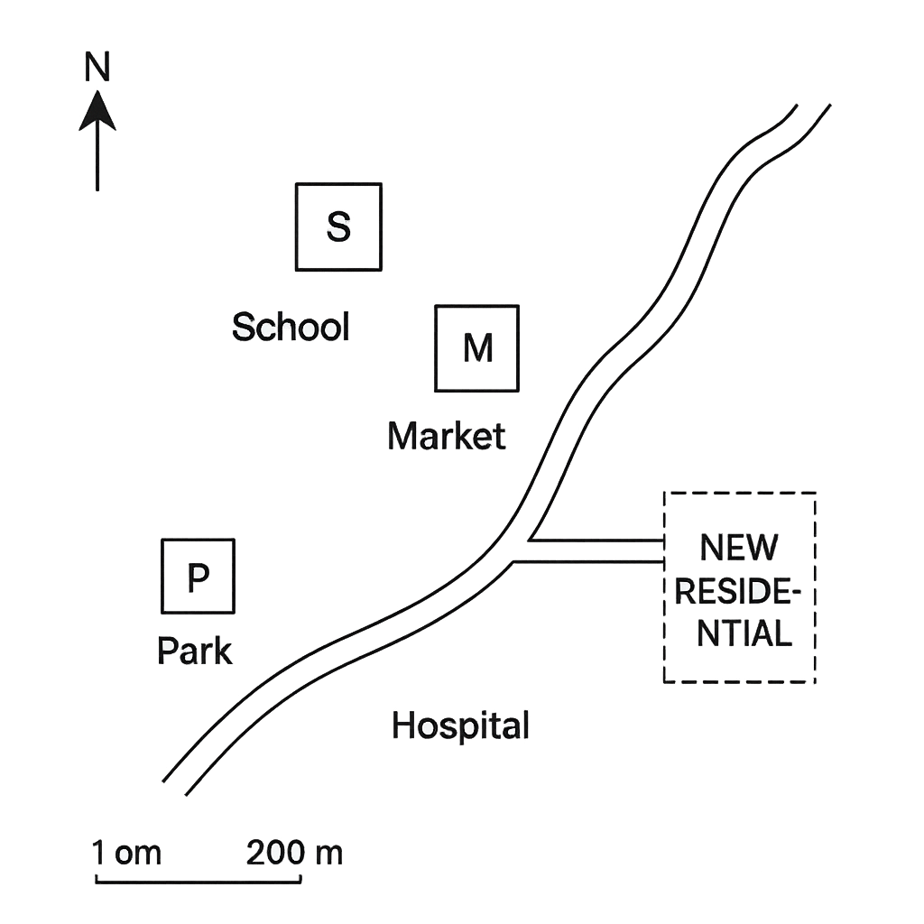
The map of a small town shows the locations of a School (S) and a Market (M). The map is drawn with north at the top and a scale of 1 cm = 200 m. The straight‑line distance between S and M on the map is 3 cm.
Question Parts
(a)
State the relative direction of the School from the Market.
(b)
Calculate the actual distance between the School and the Market in kilometres.
(c)
If a person walks from the School to the Market at a speed of 5 km/h, estimate the walking time in minutes (to the nearest minute).
Detailed Essay Solution & Marking Scheme Available

Get the step-by-step mathematical proofs, key points required by examiners, and a comprehensive breakdown from our AI Tutor.
Question 2 View Details
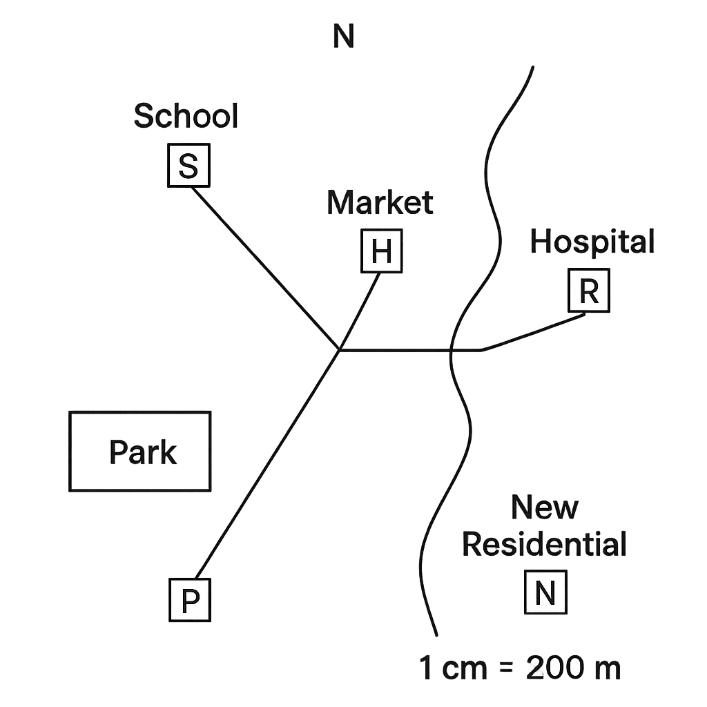
Using the same map described in Question 1 (scale 1 cm = 200 m), the rectangular park (P) measures 2 cm in length and 1.5 cm in width. The river (R) shown on the map has a measured length of 6 cm. A new road is planned to join the Hospital (H) to a residential area located 3.5 cm east of H on the map.
Question Parts
(a)
Calculate the actual area of the park in square metres and express it also in hectares.
(b)
Determine the actual length of the river in kilometres.
(c)
Find the actual length of the proposed road from the Hospital to the new residential area in metres.
(d)
If the map is redrawn with a new scale of 1 cm = 100 m, what will be the length of the river on the new map (in centimetres, to one decimal place)?
Detailed Essay Solution & Marking Scheme Available

Get the step-by-step mathematical proofs, key points required by examiners, and a comprehensive breakdown from our AI Tutor.

Question 3 View Details
The location of places on the Earth's surface is expressed using latitude and longitude.
Question Parts
(a)
Explain how latitude and longitude are measured, stating the reference lines and the units used.
(b)
Town X is situated at 5°30' N, 7°45' E and Town Y at 2°15' N, 9°30' E. Using the haversine formula and taking the Earth’s radius as 6 371 km, estimate the straight‑line distance between the two towns. Show all steps of your calculation.
(c)
Discuss how the latitude of a place influences its climate, giving at least two specific examples from different latitudinal zones in Nigeria.
Detailed Essay Solution & Marking Scheme Available

Get the step-by-step mathematical proofs, key points required by examiners, and a comprehensive breakdown from our AI Tutor.

Question 4 View Details
Weather describes the short‑term state of the atmosphere at a particular place and time.
Question Parts
(a)
Define weather and differentiate it from climate, giving two distinct features for each.
Detailed Essay Solution & Marking Scheme Available

Get the step-by-step mathematical proofs, key points required by examiners, and a comprehensive breakdown from our AI Tutor.

Question 5 View Details
The table below shows the average monthly temperature (°C) and total monthly rainfall (mm) recorded at the coastal town of Lagos over a typical year. | Month | Avg. Temp (°C) | Rainfall (mm) | |-------|----------------|---------------| | Jan | 27 | 30 | | Feb | 28 | 45 | | Mar | 29 | 80 | | Apr | 30 | 150 | | May | 31 | 210 | | Jun | 30 | 250 | | Jul | 29 | 300 | | Aug | 28 | 260 | | Sep | 27 | 180 | | Oct | 27 | 120 | | Nov | 27 | 60 | | Dec | 27 | 35 |
Question Parts
(a)
Using the Köppen climate classification system, determine the climate type of Lagos based on the data provided.
(b)
Explain two major atmospheric or geographical factors that contribute to this climate type in Lagos.
(c)
State the predominant natural vegetation that would be expected in the surrounding area and justify your answer using the climate type identified.
Detailed Essay Solution & Marking Scheme Available

Get the step-by-step mathematical proofs, key points required by examiners, and a comprehensive breakdown from our AI Tutor.

Question 6 View Details
A geologist collected a rock sample from the northern plateau of Jos. Laboratory analysis gave the following mineral composition by weight: quartz 45 %, feldspar 35 %, mica 10 %, amphibole 5 %, and other minerals 5 %. The rock is coarse‑grained, shows interlocking crystals, and has a porosity of about 2 %.
Question Parts
(a)
Classify the rock (igneous, sedimentary or metamorphic) and give its specific rock name.
(b)
Describe the igneous process (intrusive or extrusive) that most likely formed this rock, citing evidence from the description.
(c)
Assess the suitability of this rock for use as a building stone, considering its mineral composition and physical properties. Recommend one specific construction application.
Detailed Essay Solution & Marking Scheme Available

Get the step-by-step mathematical proofs, key points required by examiners, and a comprehensive breakdown from our AI Tutor.

Question 7 View Details
The table below shows the average monthly rainfall (in mm) recorded at three stations in a tropical region over a year. | Month | Station X | Station Y | Station Z | |-------|-----------|-----------|-----------| | Jan | 120 | 80 | 95 | | Feb | 110 | 85 | 100 | | Mar | 150 | 130 | 140 | | Apr | 200 | 170 | 180 | | May | 250 | 210 | 220 | | Jun | 300 | 260 | 270 | | Jul | 320 | 280 | 290 | | Aug | 310 | 270 | 280 | | Sep | 260 | 220 | 230 | | Oct | 200 | 160 | 170 | | Nov | 150 | 110 | 120 | | Dec | 130 | 90 | 100 | Using the data, answer the following:
Question Parts
(a)
Identify the month in which the region experiences its peak rainfall and justify the answer with reference to the data.
(b)
Determine which station records the greatest total annual rainfall and calculate the total.
(c)
Explain two possible geographical factors that could account for the differences in rainfall among the three stations.
Detailed Essay Solution & Marking Scheme Available

Get the step-by-step mathematical proofs, key points required by examiners, and a comprehensive breakdown from our AI Tutor.

Question 8 View Details
A coastal city has a population of 1.2 million people. The city is divided into four zones (A, B, C, D) as shown in the table below. | Zone | Area (km²) | Population (thousands) | |------|------------|------------------------| | A | 45 | 380 | | B | 30 | 250 | | C | 20 | 300 | | D | 55 | 270 | Answer the following:
Question Parts
(a)
Calculate the population density (people per km²) for each zone.
(b)
Identify the zone that is most densely populated and discuss one urban problem likely to arise there.
Detailed Essay Solution & Marking Scheme Available

Get the step-by-step mathematical proofs, key points required by examiners, and a comprehensive breakdown from our AI Tutor.

Master the Exam!

You've seen a preview, but there are thousands more questions plus AI tutor to break down complex solutions.

Unlock Full Access Available for Android & Windows
Help others prepare! Share this practice hub:
Chat with Support