waec model questions vol1 2022 geography | Objective

Prepare for your exams with waec model questions vol1 questions? Reviewing past/model questions is one of the most effective ways to guarantee a high score. This practice hub features authentic 2022 geography (Objective) questions designed to simulate the real exam environment.

Practice these randomly selected questions to test your readiness.

Question 1 View Details
A region is situated at an altitude of 1500 m above sea level. The mean temperature at sea level in the same latitude is 28 °C. Using an environmental lapse rate of 0.6 °C per 100 m, determine the most probable type of natural vegetation that would dominate the area if the average annual rainfall is 1200 mm.
Correct A. Montane forest
B. Temperate grassland
C. Alpine tundra
D. Subtropical savanna

Correct Answer: A

Want to see the full step-by-step solution? Unlock AI Explanation & Analytics
Question 2 View Details
A catchment of 5 km² receives a uniform rainfall of 40 mm over a period of 4 hours. The soil infiltration capacity is constant at 5 mm h⁻¹ during the storm. Assuming that any rainfall exceeding the infiltration capacity becomes direct runoff, calculate the volume of runoff generated (in cubic metres).
A. 150000
Correct B. 100000
C. 120000
D. 80000

Correct Answer: B

Want to see the full step-by-step solution? Unlock AI Explanation & Analytics
Question 3 View Details
River X descends 300 m over a length of 120 km before joining the main river. (a) Compute the average gradient of the river in metres per kilometre. (b) Based on the gradient, identify the dominant erosional feature that is likely to develop in the river valley.
Correct A. Gradient = 2.5 m km⁻¹; dominant feature = wide floodplain formed by lateral erosion
B. Gradient = 3.0 m km⁻¹; dominant feature = incised meander belt due to moderate erosion
C. Gradient = 2.0 m km⁻¹; dominant feature = narrow V-shaped valley formed by vertical erosion
D. Gradient = 2.8 m km⁻¹; dominant feature = braided river channel with frequent bar formation

Correct Answer: A

Want to see the full step-by-step solution? Unlock AI Explanation & Analytics
Question 4 View Details
In a region where a hard sandstone layer overlies a softer shale, differential erosion creates a cuesta. The strata dip 10° and the dip‑slope of the cuesta has a gradient of 12°. The erosion rate of sandstone is 0.2 mm yr⁻¹ while that of shale is 1.0 mm yr⁻¹. After 5 000 years, what is the height difference (in metres) between the escarpment (hard layer) and the dip‑slope (soft layer)?
Correct A. 4
B. 5
C. 3
D. 6

Correct Answer: A

Want to see the full step-by-step solution? Unlock AI Explanation & Analytics
Question 5 View Details
A drainage basin covering 200 km² receives an average annual rainfall of 1500 mm. If the runoff coefficient for the basin is 0.4, estimate the mean discharge (in cubic metres per second) contributed by the basin to the river.
A. 4.77
B. 2.86
C. 5.71
Correct D. 3.81

Correct Answer: D

Want to see the full step-by-step solution? Unlock AI Explanation & Analytics
Question 6 View Details
In 2010 the town of Ikot had a population of 120,000. By 2015 the population had risen to 138,000. During the 5‑year period the town experienced a net migration of 3,000 persons each year. The crude birth rate in 2010 was 22 per 1,000 population and the crude death rate remained unchanged through 2015. Assuming the natural increase (births minus deaths) was the same each year, calculate the crude death rate (per 1,000) for the town.
A. 20
Correct B. 17
C. 15
D. 18

Correct Answer: B

Want to see the full step-by-step solution? Unlock AI Explanation & Analytics
Question 7 View Details
A manufacturing firm is evaluating two possible sites for a new plant. Site A: land cost ₦500,000; labour cost ₦2,500 per worker per month; transport cost ₦0.30 per unit; distance to market 120 km. Site B: land cost ₦350,000; labour cost ₦3,000 per worker per month; transport cost ₦0.20 per unit; distance to market 200 km. The plant will produce 10,000 units per month and will employ 50 workers. Electricity cost without any renewable installation is ₦200,000 per month. The firm may install a solar power plant at an upfront cost of ₦2,000,000 which reduces electricity cost to ₦50,000 per month. The discount rate is 12 % per annum and the project life is 5 years. Using monthly discounting, determine which site (A or B) and whether to install the solar plant gives the lower net present value of total cash outflows (land, labour, transport, electricity). State the chosen site and the decision on the solar plant.
A. Site B without solar plant
B. Site A without solar plant
Correct C. Site A with solar plant
D. Site B with solar plant

Correct Answer: C

Want to see the full step-by-step solution? Unlock AI Explanation & Analytics
Question 8 View Details
A catchment of 2.5 km² is subjected to a design storm delivering 30 mm of rain in 2 hours. The runoff coefficient is 0.45. Using the rational method, calculate the peak discharge in m³/s. Then, assuming the discharge must be conveyed through a full‑flow circular concrete pipe, with Manning's n = 0.013 and slope = 0.001, determine the minimum pipe diameter required (in cm, rounded up to the nearest whole cm).
A. 210
B. 180
Correct C. 199
D. 225

Correct Answer: C

Want to see the full step-by-step solution? Unlock AI Explanation & Analytics
Question 9 View Details
A coastal town is exposed to storm‑surge flooding and coastal erosion. Historically, a storm surge of height ≥ 2.5 m occurs on average once every 15 years (Poisson). Coastal erosion causes a loss of 0.8 m of shoreline per year. A proposed 2 km long seawall would cost ₦150 million and would reduce storm‑surge damage by 80 % and the erosion rate by 60 %. Without the seawall, the town's expected annual damage is estimated at ₦12 million from storm surge and ₦5 million from erosion. Using an 8 % annual discount rate over a 20‑year analysis period, calculate the net present value (NPV) of the seawall project. State whether the project has a positive NPV and give the NPV (in millions of naira, to one decimal place).
A. -22.5
B. -30.1
C. -18.9
Correct D. -26.3

Correct Answer: D

Want to see the full step-by-step solution? Unlock AI Explanation & Analytics
Question 10 View Details
A rectangular open channel with a bottom width of 1.2 m and side slopes of 1 : 1 (horizontal : vertical) is to convey a design discharge of 2.5 m³/s. The Manning roughness coefficient is n = 0.015 and the permissible bed shear stress is 2.0 N/m². Determine the required flow depth (in cm, rounded to the nearest whole cm) that satisfies both the discharge requirement and the shear‑stress limit.
A. 125
B. 112
C. 138
Correct D. 119

Correct Answer: D

Want to see the full step-by-step solution? Unlock AI Explanation & Analytics
Question 11 View Details
A bus must travel a 120 km route. Its fuel consumption per kilometre varies with its average speed v (km/h) according to the formula C(v) = 0.05v + 2 (litres per km). Fuel costs ₦1.20 per litre. The driver must complete the route in at most 2.5 hours. What is the minimum possible fuel cost (in naira) for the trip?
A. ₦648.00
B. ₦720.00
C. ₦684.00
Correct D. ₦633.60

Correct Answer: D

Want to see the full step-by-step solution? Unlock AI Explanation & Analytics
Question 12 View Details
A farmer cultivates maize on a 5‑hectare field. The expected yield per hectare (in tonnes) is given by Y(F) = 2 + 0.5√F - 0.05F, where F is the amount of fertilizer applied (kg per hectare) and 0 ≤ F ≤ 100. Fertilizer costs ₦30 per kg and the market price of maize is ₦150 per kg. Determine the amount of fertilizer (rounded to the nearest whole kilogram) that maximises profit per hectare and state the maximum profit (in naira) per hectare.
A. 20 kg/ha; ₦484,800
Correct B. 25 kg/ha; ₦486,750
C. 40 kg/ha; ₦473,175
D. 30 kg/ha; ₦484,875

Correct Answer: B

Want to see the full step-by-step solution? Unlock AI Explanation & Analytics
Question 13 View Details
A map has a scale of 1:50,000. If the distance between two towns on the map measures 3.2 cm, what is the actual distance between the towns in kilometres?
Correct A. 1.6 km
B. 0.8 km
C. 2.0 km
D. 3.2 km

Correct Answer: A

Want to see the full step-by-step solution? Unlock AI Explanation & Analytics
Question 14 View Details
The following table shows the average monthly temperature (°C) and precipitation (mm) for a location. | Month | Temp (°C) | Precip (mm) | |-------|----------|-------------| | Jan | 28 | 5 | | Feb | 30 | 10 | | Mar | 32 | 20 | | Apr | 34 | 40 | | May | 33 | 80 | | Jun | 31 | 120 | | Jul | 29 | 150 | | Aug | 28 | 140 | | Sep | 27 | 80 | | Oct | 26 | 40 | | Nov | 27 | 15 | | Dec | 28 | 5 | (a) Calculate the annual mean temperature (to one decimal place). (b) Calculate the total annual precipitation (in mm). (c) Using the Köppen climate classification criteria, identify the climate type (choose from Af, Am, Aw, Cw, etc.). Köppen criteria (simplified): - If the average temperature of the coldest month > 18°C and the precipitation of the driest month > 60 mm → Af. - If the coldest month > 18°C, driest month between 30-60 mm and total annual precipitation > 1500 mm → Am. - If the coldest month > 18°C and the driest month < 30 mm → Aw. - Otherwise other categories apply.
A. Annual mean temperature = 29.4 °C; total annual precipitation = 705 mm; climate type = Af
Correct B. Annual mean temperature = 29.4 °C; total annual precipitation = 705 mm; climate type = Aw
C. Annual mean temperature = 28.9 °C; total annual precipitation = 720 mm; climate type = Am
D. Annual mean temperature = 30.1 °C; total annual precipitation = 600 mm; climate type = Aw

Correct Answer: B

Want to see the full step-by-step solution? Unlock AI Explanation & Analytics
Question 15 View Details
A soil analysis reports the following percentages by weight: sand 45 %, clay 20 %, and the remaining fraction is silt. Using the USDA soil texture triangle, identify the soil texture class of this sample.
A. Silt loam
Correct B. Sandy loam
C. Loam
D. Clay loam

Correct Answer: B

Want to see the full step-by-step solution? Unlock AI Explanation & Analytics
Question 16 View Details
The map shows two towns, A and B, located on the same meridian (same longitude). Town A is at 5° N latitude and town B is at 12° S latitude. The map scale is 1 cm = 111 km (the approximate distance represented by one degree of latitude). What is the straight‑line distance between the two towns in kilometres?
A. 1998
B. 1776
Correct C. 1887
D. 1870

Correct Answer: C

Want to see the full step-by-step solution? Unlock AI Explanation & Analytics
Question 17 View Details
A location C is recorded as 8° 30' N latitude and 3° 15' E longitude. Express the latitude of C in decimal degrees.
A. 8.3
Correct B. 8.5
C. 8.05
D. 8.75

Correct Answer: B

Want to see the full step-by-step solution? Unlock AI Explanation & Analytics
Question 18 View Details
A city recorded the following average monthly rainfall (in mm) for the first six months of the year: Jan 120, Feb 80, Mar 95, Apr 110, May 130, Jun 150. The total annual rainfall is known to be 1500 mm. Assuming that the rainfall for July to December follows the same pattern as January to June but each month is increased by the same constant amount k (in mm), determine the value of k.
Correct A. 21.67
B. 24.00
C. 20.00
D. 22.50

Correct Answer: A

Want to see the full step-by-step solution? Unlock AI Explanation & Analytics
Question 19 View Details
A river descends from its source at an elevation of 800 m to its mouth at 200 m over a horizontal distance of 120 km. The river is divided into three equal‑length reaches (each 40 km). The middle reach has a gradient twice that of the upper reach, while the lower reach has a gradient 1.5 times that of the upper reach. What is the gradient (in metres per kilometre) of the lower reach?
A. 4.0
B. 7.5
C. 6.0
Correct D. 5.0

Correct Answer: D

Want to see the full step-by-step solution? Unlock AI Explanation & Analytics
Question 20 View Details
A town had a population of 45,000 in the year 2010. Between 2010 and 2015, the natural increase (births minus deaths) contributed an average annual growth of 2.4 %, while net migration contributed an average annual increase of 0.8 %. Assuming these rates remained constant, what was the town's population at the end of 2015? (Round to the nearest whole number.)
A. 52200
B. 50985
Correct C. 52677
D. 50625

Correct Answer: C

Want to see the full step-by-step solution? Unlock AI Explanation & Analytics
Question 21 View Details
A region situated at 1,800 m above sea level records an average annual rainfall of 1,300 mm and an average temperature of 18°C. Using the following classification rules, determine the dominant vegetation type: 1. If rainfall > 1,500 mm and temperature > 20°C → Tropical rainforest. 2. If rainfall is between 800 mm and 1,500 mm and temperature is between 20°C and 30°C → Savanna. 3. If altitude > 1,500 m, the temperature at that altitude is reduced by 6.5°C per 1,000 m from sea‑level temperature. A region is classified as Montane forest if the resulting temperature is below 10°C. 4. If none of the above conditions are met → Grassland.
Correct A. Grassland
B. Tropical rainforest
C. Savanna
D. Montane forest

Correct Answer: A

Want to see the full step-by-step solution? Unlock AI Explanation & Analytics
Question 22 View Details
A farmer has 5 ha of land to allocate between cotton (cash crop) and maize (food crop). The data are: - Cotton yield: 2.5 tonnes/ha, selling price: ₦150,000 per tonne, fertilizer requirement: ₦120,000 per ha. - Maize yield: 3 tonnes/ha, selling price: ₦80,000 per tonne, fertilizer requirement: ₦40,000 per ha. The farmer has a fertilizer budget of ₦600,000 and must allocate at least 1 ha to maize for food security. Determine the allocation (ha of cotton and ha of maize) that maximises total revenue.
A. 5 ha of cotton and 0 ha of maize
B. 2 ha of cotton and 3 ha of maize
C. 3 ha of cotton and 2 ha of maize
Correct D. 4 ha of cotton and 1 ha of maize

Correct Answer: D

Want to see the full step-by-step solution? Unlock AI Explanation & Analytics
Question 23 View Details
A community is exposed to three environmental hazards. Their annual probabilities and expected monetary damages are: - Flood: probability 12%, damage ₦250 million. - Landslide: base probability 5%. If the annual rainfall exceeds 1,000 mm, the probability rises by 20% of the base value. Last year the rainfall was 1,200 mm. Damage ₦300 million. - Drought: probability 8%, damage ₦180 million. Calculate the overall expected annual loss (in million Naira) and identify which hazard should be given the highest mitigation priority based on the highest individual expected loss.
Correct A. ₦62.4 million; Flood
B. ₦70.0 million; Drought
C. ₦58.5 million; Landslide
D. ₦55.2 million; Flood

Correct Answer: A

Want to see the full step-by-step solution? Unlock AI Explanation & Analytics
Question 24 View Details
On a map the scale is 1 cm : 5 km. The straight‑line distance between Town A and Town B measures 7.2 cm on the map. What is the actual distance between the two towns in kilometres?
A. 48 km
B. 42 km
C. 30 km
Correct D. 36 km

Correct Answer: D

Want to see the full step-by-step solution? Unlock AI Explanation & Analytics
Question 25 View Details
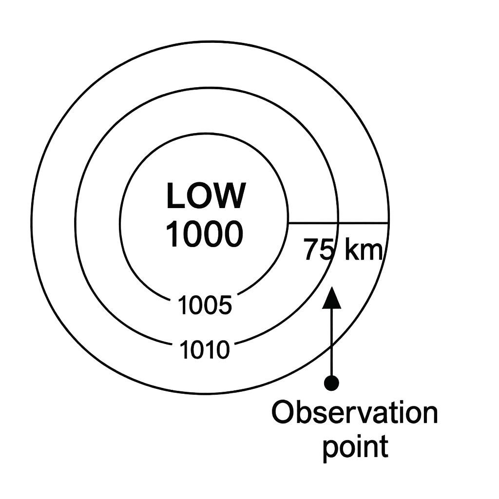
The diagram shows a low‑pressure centre (1000 hPa) with concentric isobars of 1005 hPa and 1010 hPa extending eastward. An observation point is located 75 km east of the centre. Assuming the map represents the Northern Hemisphere, what is the approximate direction of the wind at the observation point?
A. Westward
B. Eastward
C. Northward
Correct D. Southward

Correct Answer: D

Want to see the full step-by-step solution? Unlock AI Explanation & Analytics

Master the Exam!

You've seen a preview, but there are thousands more questions plus AI tutor to break down complex solutions.

Unlock Full Access Available for Android & Windows
Help others prepare! Share this practice hub:
Chat with Support