waec model questions vol1 2022 geography | Essay

Prepare for your exams with waec model questions vol1 questions? Reviewing past/model questions is one of the most effective ways to guarantee a high score. This practice hub features authentic 2022 geography (Essay) questions designed to simulate the real exam environment.

Practice these randomly selected questions to test your readiness.
Question 1 View Details
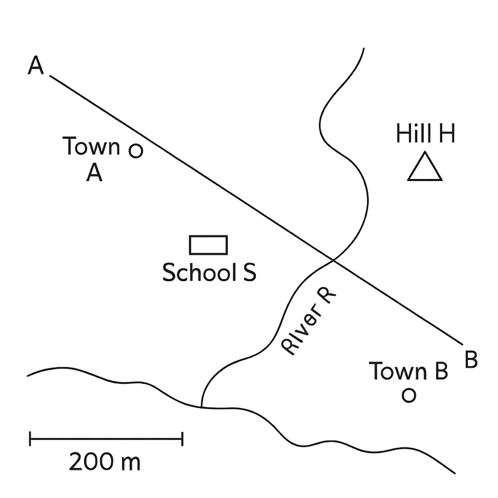
The map below shows a coastal town with the following features: Town A, Town B, School S, Hill H and a river. The north arrow points upwards. The scale bar indicates that 1 cm on the map represents 200 metres on the ground. The straight line joining Town A and Town B is drawn at a bearing of 135° from north. The map measurements are: AB = 6 cm, AS = 2 cm, HB = 2.5 cm and the perpendicular distance between the parallel sides AS and HB is 4 cm.
Question Parts
(a)
State the bearing of Town B from Town A as shown on the map.
(b)
Calculate the actual ground distance between Town A and Town B in metres.
(c)
The agricultural field bounded by Town A, School S, Hill H and Town B is a trapezium with parallel sides AS and HB. Using the map measurements given, estimate the real area of the field in hectares (1 ha = 10 000 m²).
Detailed Essay Solution & Marking Scheme Available

Get the step-by-step mathematical proofs, key points required by examiners, and a comprehensive breakdown from our AI Tutor.

Question 2 View Details
The same map as in Question 1 is used for planning a new road. The scale bar on the map shows that 1 cm represents 200 m on the ground. The map includes a small lake L that has been overlaid with a grid of squares each 0.5 cm on a side. By counting, 45 squares are completely covered by the lake.
Question Parts
(a)
State the representative fraction (RF) of the map.
(b)
A new road is to be built from Hill H to Market M. The actual ground distance between H and M is 1.2 km. Determine the length of this road on the map in centimetres, rounded to one decimal place.
(c)
Using the grid count, calculate the actual area of Lake L in square kilometres (km²).
(d)
Explain how using a map of scale 1 : 50 000 instead of the present scale would affect the accuracy of distance and area measurements on the map.
Detailed Essay Solution & Marking Scheme Available

Get the step-by-step mathematical proofs, key points required by examiners, and a comprehensive breakdown from our AI Tutor.

Question 3 View Details
Define latitude and longitude. Explain how the latitude‑longitude system is used to locate any place on the Earth's surface.
Detailed Essay Solution & Marking Scheme Available

Get the step-by-step mathematical proofs, key points required by examiners, and a comprehensive breakdown from our AI Tutor.

Question 4 View Details
A town is situated at 5° N latitude and 7° E longitude. Discuss how its position relative to the Equator and the Prime Meridian influences its climate characteristics.
Detailed Essay Solution & Marking Scheme Available

Get the step-by-step mathematical proofs, key points required by examiners, and a comprehensive breakdown from our AI Tutor.

Question 5 View Details
Define climate and differentiate it from weather, highlighting at least three key distinctions.
Detailed Essay Solution & Marking Scheme Available

Get the step-by-step mathematical proofs, key points required by examiners, and a comprehensive breakdown from our AI Tutor.

Question 6 View Details
Explain the major factors that influence the distribution of temperature across Nigeria.
Detailed Essay Solution & Marking Scheme Available

Get the step-by-step mathematical proofs, key points required by examiners, and a comprehensive breakdown from our AI Tutor.

Question 7 View Details
The Niger Delta region exhibits a variety of landforms resulting from both tectonic uplift and fluvial erosion. Using this context, answer the following.
Question Parts
(a)
Explain how a dissected plateau is formed in this region.
(b)
Discuss two major human activities that have modified the plateau and evaluate their environmental consequences.
(c)
Analyse why slope stability on the dissected plateau is a concern for settlement and propose two practical measures to mitigate the risk.
Detailed Essay Solution & Marking Scheme Available

Get the step-by-step mathematical proofs, key points required by examiners, and a comprehensive breakdown from our AI Tutor.

Question 8 View Details
A catchment in northern Nigeria covers 250 km², receives an average annual rainfall of 1200 mm, of which 40 % contributes to direct runoff. The soil infiltration rate during storm events is 12 mm hr⁻¹ and the catchment displays a dominant dendritic drainage pattern.
Question Parts
(a)
Calculate the average annual runoff volume (in cubic metres) generated from the catchment.
(b)
Estimate the peak discharge (in m³ s⁻¹) for a design storm lasting 2 hours using the Rational Method. Show all steps and state any assumptions made.
(c)
Discuss how a change from the present dendritic pattern to a trellis drainage pattern would influence flood risk and groundwater recharge in the catchment.
Detailed Essay Solution & Marking Scheme Available

Get the step-by-step mathematical proofs, key points required by examiners, and a comprehensive breakdown from our AI Tutor.

Master the Exam!

You've seen a preview, but there are thousands more questions plus AI tutor to break down complex solutions.

Unlock Full Access Available for Android & Windows
Help others prepare! Share this practice hub:
Chat with Support