waec model questions vol1 2021 geography | Essay

Prepare for your exams with waec model questions vol1 questions? Reviewing past/model questions is one of the most effective ways to guarantee a high score. This practice hub features authentic 2021 geography (Essay) questions designed to simulate the real exam environment.

Practice these randomly selected questions to test your readiness.
Question 1 View Details
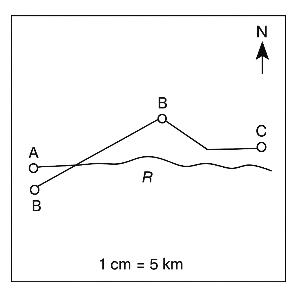
The map of the fictional district of Umuahia is shown. The map scale is 1 cm = 5 km and a north‑up compass rose is provided.
Question Parts
(a)
Using the map scale, calculate the actual straight‑line distance between Town A and Town B.
(b)
State the magnetic bearing from Town A to Town B, using the compass rose on the map.
(c)
The existing road from A to C on the map consists of three straight segments measuring 2.0 cm, 1.5 cm and 2.5 cm. If a new direct road is to be constructed, calculate its actual length in kilometres.
(d)
Discuss two advantages of using a map scale of 1 cm : 5 km (1 : 500 000) over a scale of 1 cm : 2 km (1 : 200 000) for regional planning.
Detailed Essay Solution & Marking Scheme Available

Get the step-by-step mathematical proofs, key points required by examiners, and a comprehensive breakdown from our AI Tutor.

Question 2 View Details
The same map of the Umuahia district (scale 1 cm = 5 km) is shown. A shaded region on the map represents the agricultural zone.
Question Parts
(a)
If the area of the shaded agricultural zone measures 12.5 cm² on the map, calculate its actual area in square kilometres.
Detailed Essay Solution & Marking Scheme Available

Get the step-by-step mathematical proofs, key points required by examiners, and a comprehensive breakdown from our AI Tutor.

Question 3 View Details
Town A is situated at latitude 6°30' N and longitude 3°45' E. Town B lies at latitude 5°15' N and longitude 7°20' E.
Question Parts
(a)
State the latitude and longitude of each town in decimal degrees.
(b)
Calculate the difference in latitude and longitude between the two towns in decimal degrees.
(c)
Using the spherical law of cosines, estimate the straight‑line distance between the towns. Take the Earth's radius as 6371 km.
(d)
Identify and briefly explain two sources of error that may affect the distance obtained in part (c).
Detailed Essay Solution & Marking Scheme Available

Get the step-by-step mathematical proofs, key points required by examiners, and a comprehensive breakdown from our AI Tutor.

Question 4 View Details
A weather station recorded the following data for a consecutive seven‑day period: Maximum temperature (°C): 28, 30, 32, 31, 29, 33, 34 Rainfall (mm): 0, 2, 0, 5, 0, 0, 1
Question Parts
(a)
Compute the mean (average) of the daily maximum temperatures.
(b)
Determine the median maximum temperature and the temperature range for the week.
(c)
Calculate the total rainfall recorded during the period.
(d)
Based on the temperature and rainfall pattern, suggest the likely season and discuss one implication for local agriculture.
(e)
Explain why the mean temperature alone may not fully represent the week's weather conditions.
Detailed Essay Solution & Marking Scheme Available

Get the step-by-step mathematical proofs, key points required by examiners, and a comprehensive breakdown from our AI Tutor.

Question 5 View Details
The table below shows the average monthly rainfall (in millimetres) and mean monthly temperature (in °C) recorded at the town of Ikot Ekpene over a typical year. | Month | Rainfall (mm) | Temperature (°C) | |-------|---------------|------------------| | Jan | 120 | 27 | | Feb | 80 | 28 | | Mar | 150 | 29 | | Apr | 200 | 30 | | May | 250 | 31 | | Jun | 300 | 30 | | Jul | 350 | 29 | | Aug | 320 | 28 | | Sep | 260 | 27 | | Oct | 180 | 26 | | Nov | 130 | 26 | | Dec | 100 | 27 | Answer the following questions:
Question Parts
(a)
Identify the wettest month and the driest month and state the corresponding rainfall amounts.
(b)
Calculate the coefficient of variation (CV) for the monthly rainfall and interpret what the CV indicates about the distribution of rainfall through the year.
(c)
Discuss two major impacts of this rainfall pattern on agricultural practices in the region and suggest one adaptation measure for each impact.
Detailed Essay Solution & Marking Scheme Available

Get the step-by-step mathematical proofs, key points required by examiners, and a comprehensive breakdown from our AI Tutor.

Question 6 View Details
A field investigation in the northern part of the Jos Plateau yields three rock specimens with the following observed properties: - **Sample A**: coarse‑grained, interlocking crystals, hardness 6–7 on the Mohs scale, contains quartz, feldspar and biotite; no visible fossils. - **Sample B**: fine‑grained, composed mainly of calcite, reacts vigorously with dilute hydrochloric acid, contains marine fossils such as brachiopods. - **Sample C**: medium‑grained, reddish‑brown, contains angular fragments of quartz and feldspar cemented by silica; exhibits conchoidal fracture. Answer the following questions:
Question Parts
(a)
Classify each sample (A, B, C) to the appropriate rock type (igneous, sedimentary or metamorphic) and justify your classification.
(b)
For Sample C, explain the geological process that most likely led to its formation, describing the role of weathering, transport, and cementation.
(c)
Considering construction uses, evaluate the suitability of each sample for use as a building material, citing at least one advantage and one limitation for each.
Detailed Essay Solution & Marking Scheme Available

Get the step-by-step mathematical proofs, key points required by examiners, and a comprehensive breakdown from our AI Tutor.

Question 7 View Details
Plateaus are prominent landforms in many parts of Nigeria. Discuss the geological processes that lead to the formation of plateaus and evaluate their economic significance for the country.
Question Parts
(a)
Explain two major geological processes responsible for the development of plateaus.
(b)
Assess two ways in which plateaus contribute to Nigeria's economy.
Detailed Essay Solution & Marking Scheme Available

Get the step-by-step mathematical proofs, key points required by examiners, and a comprehensive breakdown from our AI Tutor.

Question 8 View Details
River erosion can profoundly affect agricultural productivity. Using the Niger River basin as a case study, evaluate the positive and negative impacts of river erosion on farming communities.
Question Parts
(a)
Identify two beneficial effects of river erosion for agriculture.
(b)
Discuss two adverse consequences of river erosion for the same communities.
Detailed Essay Solution & Marking Scheme Available

Get the step-by-step mathematical proofs, key points required by examiners, and a comprehensive breakdown from our AI Tutor.

Master the Exam!

You've seen a preview, but there are thousands more questions plus AI tutor to break down complex solutions.

Unlock Full Access Available for Android & Windows
Help others prepare! Share this practice hub:
Chat with Support