waec model questions vol1 2020 geography | Essay

Prepare for your exams with waec model questions vol1 questions? Reviewing past/model questions is one of the most effective ways to guarantee a high score. This practice hub features authentic 2020 geography (Essay) questions designed to simulate the real exam environment.

Practice these randomly selected questions to test your readiness.
Question 1 View Details
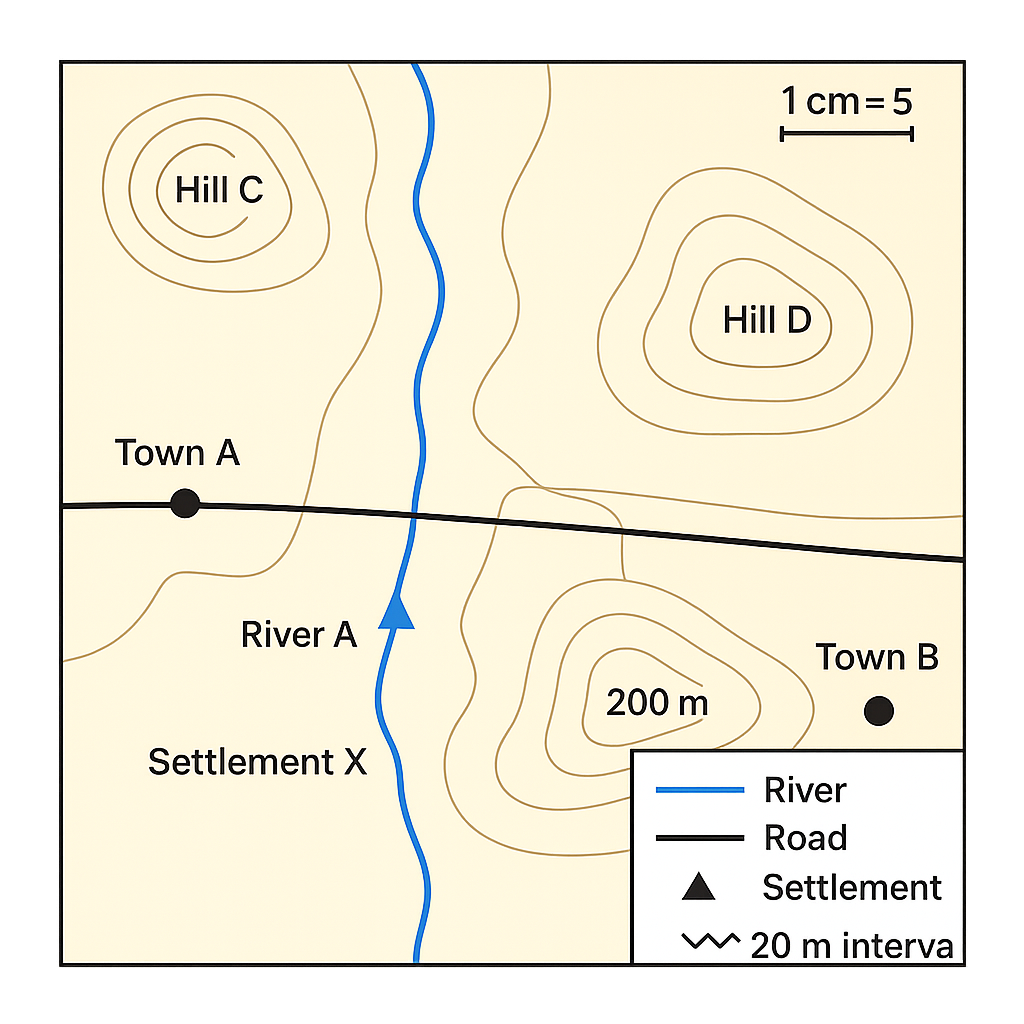
The map shown represents a portion of the Niger Delta region. The map scale is 1 cm = 5 km. The legend indicates that a blue line denotes a river, a solid black line denotes a road, a filled triangle denotes a settlement, and contour lines are drawn at 20‑m intervals. River A enters the map from the north, flows past Settlement X and joins River B which runs east‑west. The contour line passing through Hill C is marked 120 m and the line through Hill D is marked 200 m.
Question Parts
(a)
State the direction of flow of River A as shown on the map.
(b)
The straight‑line distance between Town A and Town B on the map measures 6.4 cm. Calculate the actual distance in kilometres.
(c)
Using the contour interval, determine the elevation difference between Hill C (120 m) and Hill D (200 m).
(d)
Give two advantages of using a map with a scale of 1 cm = 5 km for regional planning.
Detailed Essay Solution & Marking Scheme Available

Get the step-by-step mathematical proofs, key points required by examiners, and a comprehensive breakdown from our AI Tutor.

Question 2 View Details
The map below depicts a coastal area with a scale of 1:50,000 (i.e., 1 cm on the map equals 0.5 km on the ground). The map shows a lighthouse (L), a port (P), and a rectangular agricultural field (F).
Question Parts
(a)
The measured distance between Lighthouse L and Port P on the map is 7.2 cm. Calculate the actual distance in kilometres.
(b)
The agricultural field appears as a rectangle measuring 4.0 cm by 3.0 cm on the map. Determine the actual area of the field in square kilometres.
(c)
Discuss how the level of detail shown on the map would change if the scale were altered to 1:25,000, mentioning at least two effects on the representation of physical features.
Detailed Essay Solution & Marking Scheme Available

Get the step-by-step mathematical proofs, key points required by examiners, and a comprehensive breakdown from our AI Tutor.

Question 3 View Details
Define weather and climate. Distinguish between the two concepts by citing at least three differences.
Detailed Essay Solution & Marking Scheme Available

Get the step-by-step mathematical proofs, key points required by examiners, and a comprehensive breakdown from our AI Tutor.

Question 4 View Details
Explain the main physical and human factors that determine the distribution of tropical rainforests in Nigeria.
Detailed Essay Solution & Marking Scheme Available

Get the step-by-step mathematical proofs, key points required by examiners, and a comprehensive breakdown from our AI Tutor.

Question 5 View Details
A town in the middle belt of Nigeria records the following monthly climate data (average temperature in °C and total rainfall in mm).
Question Parts
(a)
Calculate the total annual rainfall and the mean annual temperature for the town.
(b)
Using the Köppen climate‑classification system, determine the climate type of the town. Show the reasoning steps you use, including the criteria for the main group, precipitation pattern and temperature range.
(c)
Discuss two major implications of the identified climate for agricultural practices in the region. In your answer, consider crop selection, planting season and any necessary soil‑conservation measures.
Detailed Essay Solution & Marking Scheme Available

Get the step-by-step mathematical proofs, key points required by examiners, and a comprehensive breakdown from our AI Tutor.

Question 6 View Details
A geologist surveys a river valley in the northern part of Nigeria and records the following observations:
Question Parts
(a)
Identify the three rock types described below and explain the principal processes that led to their formation.
(b)
Among the three rocks, which is most susceptible to chemical weathering in a humid tropical environment? Justify your choice by referring to mineral composition and texture.
(c)
Suggest a suitable land‑use for each of the three rock units, taking into account their strength, weathering behaviour and typical topography.
Detailed Essay Solution & Marking Scheme Available

Get the step-by-step mathematical proofs, key points required by examiners, and a comprehensive breakdown from our AI Tutor.

Question 7 View Details
A region in the northern part of Nigeria exhibits a variety of landforms, including a plateau, an inselberg, and a series of cuesta ridges. The plateau is underlain by Precambrian granite, the inselberg is a solitary granite dome, and the cuesta ridges are composed of alternating sandstone and shale layers that dip gently to the east. The climate is semi‑arid with a mean annual rainfall of about 600 mm, and the area has experienced moderate human settlement over the past century.
Question Parts
(a)
Identify the three major landforms mentioned and, for each, describe the dominant geological and geomorphological processes that led to their formation.
(b)
Discuss how each of these landforms influences patterns of human settlement, agriculture and water availability in the region.
(c)
Considering a projected increase of 150 mm in annual rainfall over the next 50 years, predict the likely geomorphological changes to each landform and suggest two mitigation measures to protect existing settlements.
Detailed Essay Solution & Marking Scheme Available

Get the step-by-step mathematical proofs, key points required by examiners, and a comprehensive breakdown from our AI Tutor.

Question 8 View Details
The River Gombe basin in the middle belt of Nigeria covers an area of 1 200 km². Within the basin there are 48 km of permanent streams, 72 km of intermittent streams and 30 km of artificial drainage channels. The underlying geology consists of Precambrian gneiss in the upper catchment and Cretaceous sandstones in the lower catchment. The climate is tropical savanna with a distinct wet season lasting 6 months.
Question Parts
(a)
Calculate the drainage density of the basin (in km km⁻²) using all types of streams, and comment on what the value indicates about the basin’s runoff characteristics.
(b)
Explain how the contrasting geology (gneiss vs. sandstone) influences the observed drainage pattern and density in the upper and lower parts of the basin.
(c)
A rapidly growing town is situated on the floodplain of the River Gombe. Propose a sustainable drainage system (SDS) for the town, outlining two key components and justifying how they reduce flood risk and protect water quality.
Detailed Essay Solution & Marking Scheme Available

Get the step-by-step mathematical proofs, key points required by examiners, and a comprehensive breakdown from our AI Tutor.

Master the Exam!

You've seen a preview, but there are thousands more questions plus AI tutor to break down complex solutions.

Unlock Full Access Available for Android & Windows
Help others prepare! Share this practice hub:
Chat with Support