waec model questions vol1 2019 geography | Objective

Prepare for your exams with waec model questions vol1 questions? Reviewing past/model questions is one of the most effective ways to guarantee a high score. This practice hub features authentic 2019 geography (Objective) questions designed to simulate the real exam environment.

Practice these randomly selected questions to test your readiness.

Question 1 View Details
A map has a scale of 1 cm : 5 km. The distance between Town A and Town B on the map measures 3.2 cm. What is the actual ground distance between the two towns in kilometres?
A. 15 km
B. 17 km
C. 12.8 km
Correct D. 16 km

Correct Answer: D

Want to see the full step-by-step solution? Unlock AI Explanation & Analytics
Question 2 View Details
The following climatic data are recorded for a location: Month | Avg. Temp (°C) | Rainfall (mm) --- | --- | --- March | 27 | 90 June | 25 | 12 August | 23 | 8 November | 26 | 70 Assume potential evapotranspiration (PET) for a month can be approximated by PET = 0.6 × Avg. Temp (in mm). The moisture deficit for a month is PET minus rainfall (a positive value indicates a deficit). Which month experiences the greatest moisture deficit?
A. June
Correct B. August
C. November
D. March

Correct Answer: B

Want to see the full step-by-step solution? Unlock AI Explanation & Analytics
Question 3 View Details
A region is exposed to two environmental hazards: flooding and landslides. - Flooding: original annual probability = 0.12, average economic loss per event = ₦150 million. - Landslides: original annual probability = 0.08, average economic loss per event = ₦200 million. Mitigation measures are introduced: - Flood mitigation reduces the flood probability by 30%. - Landslide mitigation reduces the landslide probability by 20% **and** reduces the average loss per landslide by 25%. Assuming the two hazards occur independently, calculate: 1. The expected annual economic loss after both mitigations are applied. 2. The probability that at least one of the two hazards occurs in a given year after mitigation. Provide the expected loss in millions of naira and the probability as a decimal (rounded to three decimal places).
A. ₦28.6 million; 0.143
B. ₦25.4 million; 0.005
Correct C. ₦22.2 million; 0.143
D. ₦30 million; 0.148

Correct Answer: C

Want to see the full step-by-step solution? Unlock AI Explanation & Analytics
Question 4 View Details
A map uses a scale of 1 : 50,000 (i.e., 1 cm on the map represents 0.5 km on the ground). If the distance between two villages on the map is measured as 7 cm, what is the actual distance between the villages in kilometres?
Correct A. 3.5 km
B. 0.35 km
C. 35 km
D. 7 km

Correct Answer: A

Want to see the full step-by-step solution? Unlock AI Explanation & Analytics
Question 5 View Details
A small catchment has an area of 2.5 km². For a design storm of 30 minutes, the rainfall intensity is 80 mm/hr. The runoff coefficient for the catchment is 0.6. Using the Rational Method (Q = C i A), where Q is the peak discharge in m³/s, i is the rainfall intensity in mm/hr, and A is the catchment area in hectares, calculate the peak discharge. (Use the conversion factor 0.00278 when i is in mm/hr and A in hectares.) Round your answer to one decimal place.
A. 28.7 m³/s
B. 30.1 m³/s
Correct C. 33.4 m³/s
D. 36.2 m³/s

Correct Answer: C

Want to see the full step-by-step solution? Unlock AI Explanation & Analytics
Question 6 View Details
A field has a uniform soil layer 15 cm deep. The soil's particle density is 2.65 g/cm³ and its bulk density is 1.40 g/cm³. The field capacity of the soil equals 60 % of its porosity. Calculate the volume of water (in cubic metres) retained at field capacity over one hectare of this field.
A. 460
Correct B. 425
C. 380
D. 500

Correct Answer: B

Want to see the full step-by-step solution? Unlock AI Explanation & Analytics
Question 7 View Details
A region records the following average monthly precipitation (mm): Jan 5, Feb 10, Mar 20, Apr 40, May 80, Jun 120, Jul 150, Aug 130, Sep 70, Oct 30, Nov 15, Dec 5. The average temperature of the coldest month is 26 °C. Using the Köppen criteria for a tropical savanna climate (Aw) - (i) coldest‑month mean temperature ≥ 18 °C, and (ii) the driest month precipitation < 60 mm and also less than 100 - (annual precipitation/25) - determine the climate type of the region (choose among Aw, Am, Af).
A. Af
Correct B. Aw
C. Am
D. Cw

Correct Answer: B

Want to see the full step-by-step solution? Unlock AI Explanation & Analytics
Question 8 View Details
A farmer intends to cultivate maize on 5 ha. Soil tests show available nutrients: N = 30 kg/ha, P₂O₅ = 15 kg/ha, K₂O = 40 kg/ha. The recommended nutrient rates for optimum yield are N = 120 kg/ha, P₂O₅ = 60 kg/ha and K₂O = 80 kg/ha. The farmer can use the following fertilizers only: - Urea (46% N by weight) - Single superphosphate (16% P₂O₅ by weight) - Muriate of potash (60% K₂O by weight) - A blended NPK fertilizer labelled 12‑12‑12 (12% N, 12% P₂O₅, 12% K₂O by weight) Determine the combination of these fertilizers that meets the nutrient deficits exactly while **minimising the total weight of fertilizer applied**. Give the minimum total weight (in kg, rounded to the nearest kilogram).
Correct A. 2366
B. 2250
C. 2400
D. 2600

Correct Answer: A

Want to see the full step-by-step solution? Unlock AI Explanation & Analytics
Question 9 View Details
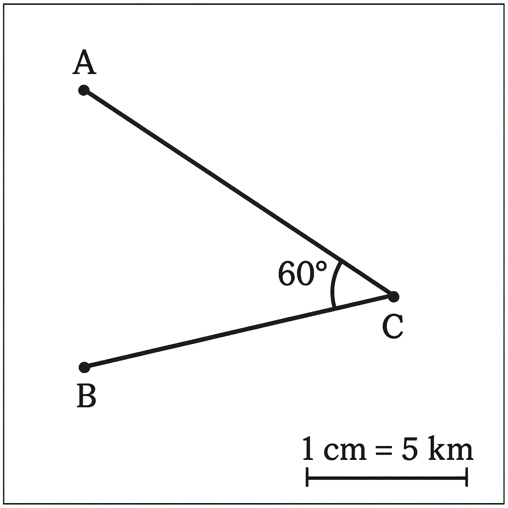
A map of a local area has a scale of 1 cm : 5 km. On the map the distance between Town A and Town B is 8 cm and the distance between Town B and Town C is 6 cm. The angle at Town B (∠ABC) is 60°. Using this information, calculate the actual straight‑line distance between Town A and Town C, expressed in kilometres and rounded to the nearest kilometre.
A. 45
B. 34
C. 40
Correct D. 36

Correct Answer: D

Want to see the full step-by-step solution? Unlock AI Explanation & Analytics
Question 10 View Details
A factory manufactures two products, A and B. Production of one unit of A requires 2 hours on Machine 1 and 1 hour on Machine 2. Production of one unit of B requires 1 hour on Machine 1 and 3 hours on Machine 2. Each week Machine 1 can operate for a maximum of 240 hours and Machine 2 for a maximum of 300 hours. The profit earned per unit is ₦500 for product A and ₦400 for product B. A contract obliges the factory to produce at least 40 units of product A each week. Determine the weekly production quantities of A and B that maximise profit and state the maximum profit (in naira).
Correct A. 84 units of A, 72 units of B; maximum profit ₦70,800
B. 80 units of A, 80 units of B; maximum profit ₦72,000
C. 90 units of A, 60 units of B; maximum profit ₦69,000
D. 84 units of A, 68 units of B; maximum profit ₦69,200

Correct Answer: A

Want to see the full step-by-step solution? Unlock AI Explanation & Analytics
Question 11 View Details
On the map, the distance between Town A and Town B is 7.5 cm. The map scale is 1 : 50 000. Calculate the actual distance between the towns in kilometres.
Correct A. 3.75
B. 0.75
C. 7.5
D. 5.0

Correct Answer: A

Want to see the full step-by-step solution? Unlock AI Explanation & Analytics
Question 12 View Details
The average monthly temperatures (in °C) of a location for January to November are: 28, 30, 32, 33, 31, 29, 27, 26, 25, 24 and 23 respectively. The average annual temperature is known to be 28°C. What was the temperature in December?
Correct A. 28
B. 27
C. 29
D. 30

Correct Answer: A

Want to see the full step-by-step solution? Unlock AI Explanation & Analytics
Question 13 View Details
A river drops from an elevation of 450 m at its source to 150 m at its mouth over a straight‑line distance of 30 km. The first 10 km have a gentle slope, the next 15 km a steep slope, and the final 5 km a moderate slope. The gentle slope is half the steep slope and the moderate slope is the arithmetic mean of the gentle and steep slopes. Determine the gradient (in m / km) of the steep section.
Correct A. 12.63
B. 13.75
C. 10.53
D. 11.20

Correct Answer: A

Want to see the full step-by-step solution? Unlock AI Explanation & Analytics
Question 14 View Details
A state covers 45 000 km². Land use distribution is: 30 % plateau, 25 % lowland, 20 % mountainous, and the remainder coastal plain. Average annual rainfall (mm) is 800 on plateau, 1 200 on lowland, 1 500 on mountainous, and 1 000 on coastal plain. What is the weighted average annual rainfall for the whole state?
A. 1120
B. 1080
Correct C. 1090
D. 1005

Correct Answer: C

Want to see the full step-by-step solution? Unlock AI Explanation & Analytics
Question 15 View Details
A town's population was 120 000 in 2010 and rose to 150 000 in 2020. The natural increase (births minus deaths) contributed an average annual growth rate of 1.5 % each year. Assuming this natural increase rate remained constant, calculate the total net migration (in persons) that occurred over the ten‑year period.
A. 12000
B. 9750
Correct C. 10734
D. 28200

Correct Answer: C

Want to see the full step-by-step solution? Unlock AI Explanation & Analytics
Question 16 View Details
A map has a scale of 1 cm : 2 km. The straight‑line distance between Town A and Town B measured on the map is 3 cm. A new road is to be built that is 20% longer than the straight‑line distance. What will be the length of the road in kilometres?
A. 5.4 km
Correct B. 7.2 km
C. 8.4 km
D. 6 km

Correct Answer: B

Want to see the full step-by-step solution? Unlock AI Explanation & Analytics
Question 17 View Details
A plateau is rectangular, 12 km long and 8 km wide. Within it lies a circular lake of radius 2 km. The plateau's average elevation is 1500 m, while the lake surface is at 1400 m. (a) Find the land area of the plateau excluding the lake (in km²). (b) Assuming the lake has an average depth of 15 m, calculate the volume of water in the lake (in cubic metres). (c) The edges of the plateau rise 150 m over a horizontal distance of 4 km. Classify the plateau as a high plateau or a tableland if the threshold slope is 0.02.
Correct A. Land area ≈ 83.4 km²; Water volume ≈ 1.88×10⁸ m³; Classification: high plateau
B. Land area ≈ 80.0 km²; Water volume ≈ 1.50×10⁸ m³; Classification: high plateau
C. Land area ≈ 84.0 km²; Water volume ≈ 1.90×10⁸ m³; Classification: tableland
D. Land area ≈ 83.4 km²; Water volume ≈ 2.00×10⁸ m³; Classification: tableland

Correct Answer: A

Want to see the full step-by-step solution? Unlock AI Explanation & Analytics
Question 18 View Details
A region receives an average annual rainfall of 1200 mm and has an average temperature of 27°C. The vegetation is tropical rainforest. Net primary productivity (NPP) can be estimated by NPP (g C m⁻² yr⁻¹) = 0.5 × (Annual Rainfall in mm) - 20 × (Mean Temperature in °C). (a) Compute the NPP for the region. (b) If 15% of the region is cleared for agriculture, reducing the NPP of that portion by 80%, what is the overall reduction in total NPP expressed as a percentage of the original total NPP?
A. 55 g C m⁻² yr⁻¹; 10% reduction
Correct B. 60 g C m⁻² yr⁻¹; 12% reduction
C. 70 g C m⁻² yr⁻¹; 15% reduction
D. 48 g C m⁻² yr⁻¹; 8% reduction

Correct Answer: B

Want to see the full step-by-step solution? Unlock AI Explanation & Analytics
Question 19 View Details
At 0900 h in City A the temperature is 30°C and the dew‑point temperature is 22°C. Atmospheric pressure is 1012 hPa. (a) Determine the relative humidity using RH = 100 × (e / e_s) where e = 6.112 exp[(17.67 Td)/(Td+243.5)] and e_s = 6.112 exp[(17.67 T)/(T+243.5)], with T and Td in °C. (b) If the temperature rises to 35°C while the dew‑point remains 22°C, what is the new relative humidity? Give answers to the nearest whole percent.
A. 60 % at 30°C; 45 % at 35°C
B. 58 % at 30°C; 42 % at 35°C
C. 65 % at 30°C; 50 % at 35°C
Correct D. 62 % at 30°C; 47 % at 35°C

Correct Answer: D

Want to see the full step-by-step solution? Unlock AI Explanation & Analytics
Question 20 View Details
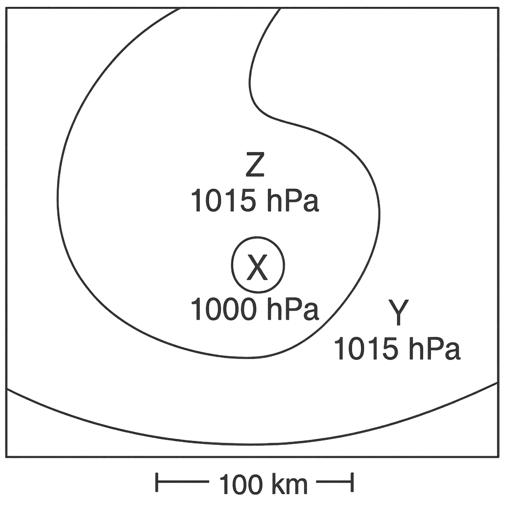
A weather diagram shows three stations: Station X at the centre (0,0) with pressure 1000 hPa, Station Y 100 km east of X with pressure 1015 hPa, and Station Z 100 km north of X with pressure 1015 hPa. Assume the pressure gradient varies linearly between stations. (a) State the direction of the pressure‑gradient vector at X. (b) Using the Coriolis effect in the Northern Hemisphere, indicate the approximate direction of the wind at X. (c) Estimate the magnitude of the pressure‑gradient force per unit mass, (1/ρ)∇p, in m s⁻², assuming air density ρ = 1.2 kg m⁻³.
A. Gradient direction: northwest; Wind direction: towards northeast (from southwest); PGF ≈ 0.025 m s⁻²
B. Gradient direction: east; Wind direction: towards south (from north); PGF ≈ 0.020 m s⁻²
Correct C. Gradient direction: northeast; Wind direction: towards southeast (from northwest); PGF ≈ 0.018 m s⁻²
D. Gradient direction: north; Wind direction: towards east (from west); PGF ≈ 0.015 m s⁻²

Correct Answer: C

Want to see the full step-by-step solution? Unlock AI Explanation & Analytics
Question 21 View Details
A manufacturing plant produces two products, A and B. Each unit of product A requires 4 machine‑hours and 3 labour‑hours and yields a profit of ₦1,200. Each unit of product B requires 6 machine‑hours and 2 labour‑hours and yields a profit of ₦1,500. In a week the plant has at most 480 machine‑hours and 360 labour‑hours available. A contract obliges the plant to produce at least 20 units of product A. Determine the number of units of each product that should be produced to maximise weekly profit and state the maximum profit.
Correct A. Produce 120 units of product A and 0 units of product B; maximum profit = ₦144,000
B. Produce 80 units of product A and 20 units of product B; maximum profit = ₦126,000
C. Produce 100 units of product A and 10 units of product B; maximum profit = ₦135,000
D. Produce 70 units of product A and 20 units of product B; maximum profit = ₦114,000

Correct Answer: A

Want to see the full step-by-step solution? Unlock AI Explanation & Analytics
Question 22 View Details
Town X is located at 6°30' N, 7°30' E and Town Y at 5°45' N, 8°15' E. Using the approximation that 1° of latitude equals 111 km and that the length of a degree of longitude equals 111 km × cos (average latitude), estimate the straight‑line distance between the two towns in kilometres (round to the nearest kilometre).
A. ≈124 km
B. ≈110 km
C. ≈100 km
Correct D. ≈117 km

Correct Answer: D

Want to see the full step-by-step solution? Unlock AI Explanation & Analytics
Question 23 View Details
A rock sample consists of 55 % quartz, 30 % feldspar and 15 % mica. It is described as having interlocking crystals that solidified from cooling magma. (a) Identify the rock type. (b) The compressive strength (in MPa) of granite can be approximated by S = 150 + 0.5 × (% quartz). Determine whether this rock meets a construction requirement of at least 180 MPa.
Correct A. Granite; not suitable for construction (strength 177.5 MPa < 180 MPa)
B. Granite; suitable for construction (strength 182.5 MPa ≥ 180 MPa)
C. Granite; not suitable for construction (strength 165 MPa < 180 MPa)
D. Diorite; not suitable for construction (strength 177.5 MPa < 180 MPa)

Correct Answer: A

Want to see the full step-by-step solution? Unlock AI Explanation & Analytics
Question 24 View Details
Three towns are to be served by a new service station. Their planar coordinates (in km) are: Town A (2, 3) with population 2 000, Town B (8, 5) with population 3 500, and Town C (5, 12) with population 1 500. Assuming the station should be placed at the point that minimises the total weighted travel distance (population × distance), determine the optimal coordinates of the station (to two decimal places) and the minimum total weighted distance (in km·person, rounded to the nearest whole number).
Correct A. Location (5.64 km, 5.93 km); minimum weighted distance ≈ 27 380 km·person
B. Location (6.12 km, 5.47 km); minimum weighted distance ≈ 28 150 km·person
C. Location (5.64 km, 5.93 km); minimum weighted distance ≈ 26 900 km·person
D. Location (5.20 km, 6.30 km); minimum weighted distance ≈ 27 380 km·person

Correct Answer: A

Want to see the full step-by-step solution? Unlock AI Explanation & Analytics
Question 25 View Details
A soil sample contains 20 % clay, 35 % silt and 45 % sand. (a) Classify the soil texture using the USDA triangle (state the class). (b) The water‑holding capacity (WHC) in millimetres can be estimated by WHC = 0.3 × %clay + 0.1 × %silt. Calculate the WHC and state whether the soil is suitable for rice cultivation, which requires a WHC of at least 20 mm.
Correct A. Loam; WHC = 9.5 mm; not suitable for rice
B. Sandy loam; WHC = 12.0 mm; not suitable for rice
C. Silt loam; WHC = 8.0 mm; not suitable for rice
D. Clay loam; WHC = 9.5 mm; suitable for rice

Correct Answer: A

Want to see the full step-by-step solution? Unlock AI Explanation & Analytics

Master the Exam!

You've seen a preview, but there are thousands more questions plus AI tutor to break down complex solutions.

Unlock Full Access Available for Android & Windows
Help others prepare! Share this practice hub:
Chat with Support