waec model questions vol1 2018 geography | Essay

Prepare for your exams with waec model questions vol1 questions? Reviewing past/model questions is one of the most effective ways to guarantee a high score. This practice hub features authentic 2018 geography (Essay) questions designed to simulate the real exam environment.

Practice these randomly selected questions to test your readiness.
Question 1 View Details
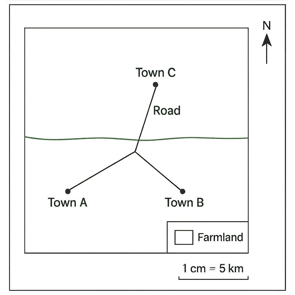
The map shows three towns – Town A, Town B and Town C – a river and a road. The scale is 1 cm = 5 km and north is at the top of the map.
Question Parts
(a)
Determine the actual distance between Town A and Town B.
(b)
State the bearing of Town B from Town A (give the bearing to the nearest tenth of a degree).
(c)
Identify the type of land use that predominates in the area bounded by the river to the north and the road to the south.
Detailed Essay Solution & Marking Scheme Available

Get the step-by-step mathematical proofs, key points required by examiners, and a comprehensive breakdown from our AI Tutor.
Question 2 View Details
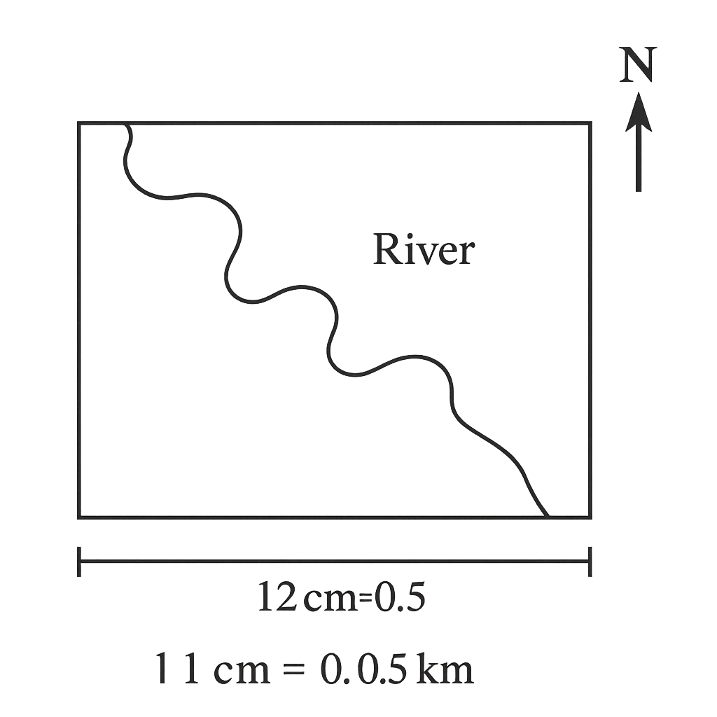
A topographic map of a river basin is drawn at a scale of 1 cm = 0.5 km. On the map the length of the main river from its source to its mouth measures 12 cm. The basin is approximated as a rectangle whose length equals the river length on the map and whose width is 4 cm on the map.
Question Parts
(a)
Calculate the actual length of the river in kilometres.
(b)
Determine the actual area of the river basin in square kilometres.
(c)
Explain how using a larger scale (e.g., 1 cm = 2 km) would affect the accuracy of the measurements obtained from the map.
Detailed Essay Solution & Marking Scheme Available

Get the step-by-step mathematical proofs, key points required by examiners, and a comprehensive breakdown from our AI Tutor.

Question 3 View Details
The table below gives the geographical coordinates of three Nigerian towns. | Town | Latitude (° N) | Longitude (° E) | |------|----------------|-----------------| | A | 7° 30' | 5° 45' | | B | 9° 15' | 6° 20' | | C | 4° 55' | 7° 10' | Using the information above, answer the following questions.
Question Parts
(a)
Identify which town lies closest to the equator and justify your answer.
(b)
Calculate the north‑south angular distance between Town A and Town B. Express your answer in degrees and minutes.
(c)
If the Earth rotates 360° in 24 hours, determine the time difference (in minutes) between the local solar times of Town A and Town B based on their longitudes. Explain briefly how this difference influences the assignment of time zones in Nigeria.
(d)
Discuss how the latitudinal position of each town influences its general climate type, referring to the Köppen climate classification system.
Detailed Essay Solution & Marking Scheme Available

Get the step-by-step mathematical proofs, key points required by examiners, and a comprehensive breakdown from our AI Tutor.

Question 4 View Details
The weather observations for a coastal town over a seven‑day period are shown in the table. | Day | Max Temp (°C) | Min Temp (°C) | Rainfall (mm) | Humidity (%) | |-----|---------------|---------------|---------------|--------------| | 1 | 30 | 22 | 5 | 78 | | 2 | 32 | 23 | 0 | 70 | | 3 | 33 | 24 | 12 | 85 | | 4 | 31 | 22 | 8 | 80 | | 5 | 34 | 25 | 0 | 68 | | 6 | 35 | 26 | 15 | 88 | | 7 | 33 | 24 | 3 | 75 | Answer the following questions based on the data provided.
Question Parts
(a)
Calculate the mean daily temperature for each day (average of max and min). Then determine the average temperature for the whole week.
(b)
Determine the total rainfall for the week and identify the day with the highest rainfall. Discuss a plausible reason for the variation in rainfall using the humidity data.
(c)
Describe the trend shown by the maximum temperature over the seven days and explain what this trend suggests about the prevailing weather pattern.
(d)
Explain how the observed weather pattern (rising temperatures and fluctuating humidity) could affect agricultural activities such as crop planting and pest management in the region.
Detailed Essay Solution & Marking Scheme Available

Get the step-by-step mathematical proofs, key points required by examiners, and a comprehensive breakdown from our AI Tutor.

Question 5 View Details
The table below shows the average monthly temperature (°C) and total monthly rainfall (mm) recorded at the coastal town of Ikot Ekpene over a 12‑month period. | Month | Avg. Temp (°C) | Rainfall (mm) | |-------|----------------|---------------| | Jan | 27 | 210 | | Feb | 28 | 190 | | Mar | 29 | 150 | | Apr | 30 | 120 | | May | 31 | 80 | | Jun | 30 | 40 | | Jul | 28 | 20 | | Aug | 27 | 25 | | Sep | 27 | 45 | | Oct | 27 | 90 | | Nov | 27 | 150 | | Dec | 27 | 200 | Using this information, answer the following: a) Classify the climate of Ikot Ekpene according to the Köppen climate classification system. State the code and explain the criteria used. b) Identify the two dominant factors that control the seasonal distribution of rainfall in this region and discuss how each factor influences the pattern. c) Considering the climate characteristics identified, evaluate two possible impacts of a projected 2 °C rise in average temperature on the agricultural productivity of the area. Provide specific examples of crops that may be affected.
Detailed Essay Solution & Marking Scheme Available

Get the step-by-step mathematical proofs, key points required by examiners, and a comprehensive breakdown from our AI Tutor.

Question 6 View Details
A field geologist examines a rock outcrop in the Jos Plateau and records the following observations: - The rock is coarse‑grained, composed mainly of quartz, feldspar and biotite. - It exhibits interlocking crystals with visible grain boundaries. - The rock has a hardness of 6–7 on the Mohs scale and a specific gravity of about 2.7. - No fossils are present, and the rock shows faint foliation that dips at 30° toward the southeast. Answer the following: a) Identify the most probable rock type (igneous, sedimentary or metamorphic) and justify your choice using the observed properties. b) Explain the geological processes that could have produced the identified rock, outlining the sequence from source material to the final rock. c) Discuss two engineering considerations that must be evaluated before using this rock as a foundation material for a new bridge in the area.
Detailed Essay Solution & Marking Scheme Available

Get the step-by-step mathematical proofs, key points required by examiners, and a comprehensive breakdown from our AI Tutor.

Question 7 View Details
The Jos Plateau in central Nigeria is an example of a dissected plateau that has been shaped by a combination of tectonic uplift and prolonged fluvial erosion.
Question Parts
(a)
Describe the sequential processes that lead to the formation of a dissected plateau such as the Jos Plateau.
(b)
Discuss two ways in which the existence of this dissected plateau influences human settlement patterns and economic activities in the region.
(c)
Increasing agricultural expansion has accelerated soil erosion on the plateau. Propose three integrated land‑use measures that could reduce erosion while still supporting agricultural productivity, and justify each measure.
Detailed Essay Solution & Marking Scheme Available

Get the step-by-step mathematical proofs, key points required by examiners, and a comprehensive breakdown from our AI Tutor.

Question 8 View Details
A river basin in northern Nigeria exhibits a dendritic drainage pattern on its topographic map.
Question Parts
(a)
Explain why a dendritic drainage pattern typically develops in such a basin, referring to the nature of the underlying geology and the slope of the terrain.
(b)
Rapid urbanisation has altered the basin’s hydrology and water quality. Evaluate two major environmental impacts of this change and, for each impact, suggest one engineering or policy intervention that could mitigate the problem, explaining how it works.
Detailed Essay Solution & Marking Scheme Available

Get the step-by-step mathematical proofs, key points required by examiners, and a comprehensive breakdown from our AI Tutor.

Master the Exam!

You've seen a preview, but there are thousands more questions plus AI tutor to break down complex solutions.

Unlock Full Access Available for Android & Windows
Help others prepare! Share this practice hub:
Chat with Support