waec model questions vol1 2017 geography | Objective

Prepare for your exams with waec model questions vol1 questions? Reviewing past/model questions is one of the most effective ways to guarantee a high score. This practice hub features authentic 2017 geography (Objective) questions designed to simulate the real exam environment.

Practice these randomly selected questions to test your readiness.

Question 1 View Details
A rectangular agricultural field measures 2 km by 2.5 km (area = 5 km²). During a storm the rainfall intensity is 80 mm/h for 2 hours and the soil infiltration rate is 15 mm/h. The design calls for parallel drainage ditches running along the 2 km side of the field. Each ditch is 1 m wide and may hold water to a maximum depth of 0.30 m. Determine the maximum spacing (in metres, to one decimal place) that can be allowed between two successive ditches so that the runoff from the strip they drain can be safely conveyed.
Correct A. 2.3
B. 2.9
C. 1.8
D. 3.0

Correct Answer: A

Want to see the full step-by-step solution? Unlock AI Explanation & Analytics
Question 2 View Details
The population of a settlement increased from 12,000 to 18,000 over a period of 5 years. Assuming the growth continues at the same compound annual rate, calculate the projected population after another 5 years and state whether the settlement will still be classified as a town (population ≥ 15,000 but < 30,000) or a city (population ≥ 30,000).
Correct A. 27000
B. 30000
C. 18000
D. 22500

Correct Answer: A

Want to see the full step-by-step solution? Unlock AI Explanation & Analytics
Question 3 View Details
A driver must travel from point A to point B. Two routes are available:\n\nRoute 1: distance 120 km, average speed 60 km/h, fuel consumption 8 L per 100 km.\nRoute 2: consists of two segments - the first 40 km at 50 km/h with fuel consumption 9 L per 100 km, the second 60 km at 80 km/h with fuel consumption 7 L per 100 km.\nFuel costs ₦150 per litre and the driver values time at ₦200 per hour. Which route results in the lower total cost (fuel cost plus time cost)?
A. Neither route is feasible
Correct B. Route 2
C. Route 1
D. Both routes have equal cost

Correct Answer: B

Want to see the full step-by-step solution? Unlock AI Explanation & Analytics
Question 4 View Details
In a community the age distribution is as follows: 0‑14 years = 4,500 persons, 15‑64 years = 12,000 persons, 65 years and over = 1,500 persons. Calculate (a) the total dependency ratio (young + old dependents per 100 working‑age persons) and (b) the old‑age dependency ratio (old dependents per 100 working‑age persons). Express your answers as percentages to one decimal place.
A. Total dependency ratio = 55.0%, old‑age dependency ratio = 15.0%
B. Total dependency ratio = 45.0%, old‑age dependency ratio = 10.0%
C. Total dependency ratio = 60.0%, old‑age dependency ratio = 20.0%
Correct D. Total dependency ratio = 50.0%, old‑age dependency ratio = 12.5%

Correct Answer: D

Want to see the full step-by-step solution? Unlock AI Explanation & Analytics
Question 5 View Details
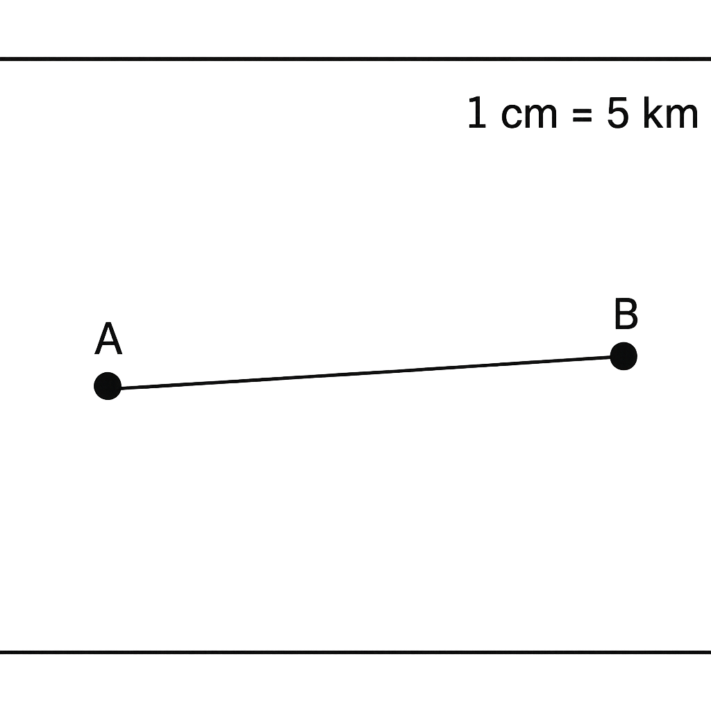
A schematic map shows Town A and Town B separated by a straight line that measures 3 cm on the map. The map scale is 1 cm : 5 km. What is the actual distance between the two towns in kilometres?
Correct A. 15
B. 10
C. 20
D. 25

Correct Answer: A

Want to see the full step-by-step solution? Unlock AI Explanation & Analytics
Question 6 View Details
A limestone consisting of pure calcite (CaCO₃) weighing 200 kg is mixed with 50 kg of silica (SiO₂) and heated so that the reaction CaCO₃ + SiO₂ → CaSiO₃ + CO₂ proceeds to completion. Using the molar masses CaCO₃ = 100.09 g mol⁻¹, SiO₂ = 60.08 g mol⁻¹ and CaSiO₃ = 116.16 g mol⁻¹, determine (i) the mass of wollastonite (CaSiO₃) formed and (ii) the mass of unreacted calcite remaining.
Correct A. 96.7 kg wollastonite; 116.7 kg calcite
B. 102.5 kg wollastonite; 110.5 kg calcite
C. 90.0 kg wollastonite; 120.0 kg calcite
D. 85.3 kg wollastonite; 125.7 kg calcite

Correct Answer: A

Want to see the full step-by-step solution? Unlock AI Explanation & Analytics
Question 7 View Details
A river drops from an elevation of 1 200 m at its source to sea level over a length of 150 km. The gradient in the upper 40 km is twice that of the lower 110 km. If the average erosion rate (mm yr⁻¹) is proportional to the square of the local gradient, what is the ratio of the average erosion rate in the upper stretch to that in the lower stretch?
A. 3:1
B. 5:1
C. 2:1
Correct D. 4:1

Correct Answer: D

Want to see the full step-by-step solution? Unlock AI Explanation & Analytics
Question 8 View Details
A firm plans to locate a new plant at either site A or site B. The variable production cost per unit consists of labour cost plus transport cost per unit. Labour cost per unit is ₦150 at A and ₦120 at B. Transport cost per unit equals distance to the main market multiplied by ₦0.8 per km; distances are 80 km for A and 150 km for B. Site B receives a 5 % tax incentive on its total variable cost and a one‑time subsidy of ₦200 000, amortised over 5 years. The plant will produce 10 000 units per year. Which site yields the lower total annual cost and by how much (in ₦)?
Correct A. Location A; cost difference ₦100,000
B. Location A; cost difference ₦120,000
C. Location B; cost difference ₦95,000
D. Location B; cost difference ₦85,000

Correct Answer: A

Want to see the full step-by-step solution? Unlock AI Explanation & Analytics
Question 9 View Details
A region is divided into three zones with the data below: | Zone | Area (km²) | Rainfall (mm) | Temp (°C) | Population | |------|------------|---------------|----------|------------| | Coastal | 1 200 | 1 800 | 27 | 600 000 | | Inland plateau | 2 800 | 1 200 | 22 | 1 200 000 | | Highland | 1 000 | 800 | 15 | 200 000 | The region's total GDP is ₦9.6 trillion, allocated as 40 % agriculture, 35 % industry and 25 % services. Assume: - Agricultural output ∝ rainfall × area, - Industrial output ∝ population × (30 - temperature), - Services output ∝ population × (rainfall/100). Using these proportionalities, determine which zone contributes the greatest share of the region's GDP and state its contribution (in trillion Naira, rounded to two decimal places).
A. Coastal; ₦4.32 trillion
Correct B. Inland plateau; ₦5.57 trillion
C. Highland; ₦2.15 trillion
D. Inland plateau; ₦6.03 trillion

Correct Answer: B

Want to see the full step-by-step solution? Unlock AI Explanation & Analytics
Question 10 View Details
A granite outcrop of mass 5 000 kg has the following mineral composition by weight: quartz 30 %, feldspar 25 %, mica 20 %, amphibole 15 %, biotite 10 %. During chemical weathering, feldspar and mica each lose 40 % of their mass, which is leached away, and the remaining 60 % is transformed into clay minerals. Quartz remains unchanged. Amphibole loses 20 % of its mass, which is leached away, and the remaining 80 % becomes iron oxides. Biotite remains unchanged. Calculate (i) the mass of clay minerals produced and (ii) the final mass of the soil layer (in kg, to one decimal place).
A. 2250 kg clay minerals; 4850.0 kg soil
Correct B. 1350 kg clay minerals; 3950.0 kg soil
C. 1350 kg clay minerals; 4100.0 kg soil
D. 900 kg clay minerals; 3500.0 kg soil

Correct Answer: B

Want to see the full step-by-step solution? Unlock AI Explanation & Analytics
Question 11 View Details
A map legend shows that a blue line denotes a railway and a black line denotes a highway. If a black line on the map connects City A to City B, what type of feature does it represent?
A. river
Correct B. highway
C. pipeline
D. railway

Correct Answer: B

Want to see the full step-by-step solution? Unlock AI Explanation & Analytics
Question 12 View Details
A region receives an average annual rainfall of 1,200 mm and has an average temperature of 27 °C. The dry season lasts for 1.5 months. Based on these data, identify the dominant vegetation type in the region.
A. temperate grassland
Correct B. tropical savanna
C. desert
D. tropical rainforest

Correct Answer: B

Want to see the full step-by-step solution? Unlock AI Explanation & Analytics
Question 13 View Details
A location has the following climate data: coldest month mean temperature = 12 °C, warmest month mean temperature = 28 °C, total annual precipitation = 800 mm with 70 % falling in the summer months. The wettest month receives 120 mm of rain while the driest month receives 10 mm. Using the Köppen classification, what is the climate type of this location?
Correct A. Cwa
B. Dwa
C. Cfa
D. Cwb

Correct Answer: A

Want to see the full step-by-step solution? Unlock AI Explanation & Analytics
Question 14 View Details
A river originates at an elevation of 350 m and flows to a point 150 m above sea level that is 20 km downstream (horizontal distance). Determine the river's gradient and state whether it is classified as a steep or gentle gradient (threshold: steep > 5 %).
Correct A. gentle gradient
B. steep gradient
C. extremely steep gradient
D. moderate gradient

Correct Answer: A

Want to see the full step-by-step solution? Unlock AI Explanation & Analytics
Question 15 View Details
A map has a scale of 1 : 50,000. If the distance between two towns on the map measures 3 cm, what is the actual distance between the towns in kilometres?
A. 3 km
Correct B. 1.5 km
C. 0.6 km
D. 15 km

Correct Answer: B

Want to see the full step-by-step solution? Unlock AI Explanation & Analytics
Question 16 View Details
A region records the following monthly rainfall (in mm): Jan 120, Feb 80, Mar 70, Apr 50, May 40, Jun 30, Jul 20, Aug 25, Sep 35, Oct 60, Nov 100, Dec 150. Using the criteria: Rainforest >2000 mm annual; Savanna 900‑2000 mm with a dry season of at most 2 consecutive months receiving <50 mm; Grassland 300‑900 mm with a dry season of more than 3 consecutive months receiving <50 mm; Desert <300 mm. Determine the dominant vegetation type of the region.
A. Savanna
B. Rainforest
C. Desert
Correct D. Grassland

Correct Answer: D

Want to see the full step-by-step solution? Unlock AI Explanation & Analytics
Question 17 View Details
The average monthly temperatures (°C) of a location are: Jan 22, Feb 24, Mar 27, Apr 30, May 33, Jun 35, Jul 34, Aug 33, Sep 30, Oct 27, Nov 24, Dec 22. The area receives 1200 mm of rain annually, with May and June each receiving less than 30 mm. According to the Köppen system, classify the climate of the location (choose among Af, Aw, Cw, Dfb).
A. Cw
B. Dfb
C. Af
Correct D. Aw

Correct Answer: D

Want to see the full step-by-step solution? Unlock AI Explanation & Analytics
Question 18 View Details
After a volcanic eruption, a 100‑unit area undergoes primary succession. Pioneer species colonise bare ground at 5 % of the remaining bare area each year until they occupy 40 % of the total area. Thereafter, secondary species replace pioneer vegetation at a rate of 10 % of the existing pioneer area per year. How many years from the start of succession will it take for secondary species to cover at least 30 % of the total area?
A. 30
B. 18
Correct C. 22
D. 24

Correct Answer: C

Want to see the full step-by-step solution? Unlock AI Explanation & Analytics
Question 19 View Details
At 2 pm the air temperature is 30 °C and the wet‑bulb temperature is 22 °C. Using the approximation \(e = 6.112\exp\bigl(\frac{17.62T}{243.12+T}\bigr)\) (hPa) for saturation vapour pressure, compute the relative humidity (RH = 100 · e_{wb}/e_{t}). State the RH to the nearest percent and indicate whether thunderstorms are likely if RH > 70 % is required.
Correct A. Relative humidity ≈ 62%; thunderstorms unlikely
B. Relative humidity ≈ 68%; thunderstorms unlikely
C. Relative humidity ≈ 55%; thunderstorms unlikely
D. Relative humidity ≈ 78%; thunderstorms likely

Correct Answer: A

Want to see the full step-by-step solution? Unlock AI Explanation & Analytics
Question 20 View Details
A soil layer 0.60 m deep has a bulk density of 1.3 g cm⁻³. Its field‑capacity moisture content is 30 % (by weight) and its wilting‑point moisture content is 15 % (by weight). If the soil is initially at field capacity and a crop reduces the moisture to the wilting point, how many millimetres of water must be applied by irrigation to restore the soil to field capacity?
A. 105
B. 150
Correct C. 117
D. 130

Correct Answer: C

Want to see the full step-by-step solution? Unlock AI Explanation & Analytics
Question 21 View Details
A soil sample has a bulk density of 1.4 g cm⁻³ and a porosity of 48 %. At field capacity the soil water content occupies 30 % of the total soil volume. How deep (in centimetres) must the soil be, over one hectare, to store exactly 5 000 m³ of water at field capacity?
A. 180.2 cm
Correct B. 166.7 cm
C. 150.0 cm
D. 200.5 cm

Correct Answer: B

Want to see the full step-by-step solution? Unlock AI Explanation & Analytics
Question 22 View Details
The air temperature is -5 °C and the wind speed is 20 km h⁻¹. Using the wind‑chill index formula WCI = 13.12 + 0.6215 T - 11.37 V^{0.16} + 0.3965 T V^{0.16}, where T is the temperature in °C and V the wind speed in km h⁻¹, determine the wind‑chill temperature (to one decimal place).
A. -9.8 °C
B. -7.0 °C
C. -13.2 °C
Correct D. -11.5 °C

Correct Answer: D

Want to see the full step-by-step solution? Unlock AI Explanation & Analytics
Question 23 View Details
A hill rises 250 m over a horizontal distance of 1.5 km. Calculate the slope angle in degrees to the nearest tenth and state whether the slope is gentle (<15°), moderate (15°-30°) or steep (>30°).
Correct A. Gentle
B. Moderate
C. Very steep
D. Steep

Correct Answer: A

Want to see the full step-by-step solution? Unlock AI Explanation & Analytics
Question 24 View Details
A community faces two hazards. - Flood: probability of occurrence 0.02 yr⁻¹, expected damage ₦150 million. A mitigation programme costing ₦20 million reduces the damage by 70 %. - Landslide: probability 0.01 yr⁻¹, expected damage ₦200 million. Mitigation costing ₦30 million reduces the damage by 50 %. For each hazard compute the expected annual loss after mitigation and indicate which hazard still poses the higher expected loss.
Correct A. Landslide
B. Wildfire
C. Flood
D. Earthquake

Correct Answer: A

Want to see the full step-by-step solution? Unlock AI Explanation & Analytics
Question 25 View Details
In a region the original rock‑type distribution is 40 % igneous, 35 % sedimentary and 25 % metamorphic. Due to tectonic processes, 10 % of the igneous rocks are metamorphosed into metamorphic rocks, and 5 % of the sedimentary rocks are transformed into igneous rocks. What is the new percentage of metamorphic rocks in the region (to the nearest whole percent)?
A. 30 %
B. 31 %
C. 27 %
Correct D. 29 %

Correct Answer: D

Want to see the full step-by-step solution? Unlock AI Explanation & Analytics

Master the Exam!

You've seen a preview, but there are thousands more questions plus AI tutor to break down complex solutions.

Unlock Full Access Available for Android & Windows
Help others prepare! Share this practice hub:
Chat with Support