waec model questions vol1 2017 geography | Essay

Prepare for your exams with waec model questions vol1 questions? Reviewing past/model questions is one of the most effective ways to guarantee a high score. This practice hub features authentic 2017 geography (Essay) questions designed to simulate the real exam environment.

Practice these randomly selected questions to test your readiness.
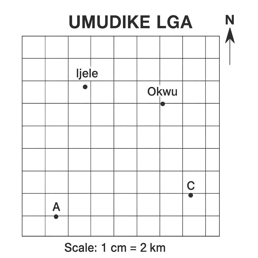
Question 1 View Details
A map of the fictional Umudike Local Government Area (LGA) is provided. The map uses a scale of 1 cm = 2 km. It includes a north arrow pointing upwards, a grid of 1‑cm squares, and the following labelled points: - Ijele (grid square (2,5)) - Okwu (grid square (5.5,5)) - A (grid square (1,1)) - B (grid square (6,1)) - C (grid square (6,4)) - D (grid square (1,4)) The quadrilateral A‑B‑C‑D represents an agricultural zone. Using a ruler, the straight‑line distance between Ijele and Okwu on the map measures 3.5 cm. Answer the questions that follow.
Question Parts
(a)
State the true distance in kilometres between Ijele and Okwu.
(b)
Determine the approximate real area (in km²) of the agricultural zone bounded by A, B, C and D using the grid‑square method.
(c)
If a straight road is to be built from Ijele to Okwu, state the bearing of the road to the nearest degree (north is 0° and bearings are measured clockwise).
Detailed Essay Solution & Marking Scheme Available

Get the step-by-step mathematical proofs, key points required by examiners, and a comprehensive breakdown from our AI Tutor.

Question 2 View Details
A second map shows the neighbouring Riverine District. The map scale is 1 cm = 5 km. The map contains a north arrow, a grid of 1‑cm squares, and the following labelled locations: - Town X (grid (3,2)) - Town Y (grid (9,7)) - Lake Z is represented by an irregular shape whose boundary passes through the grid points P(2,5), Q(4,8), R(7,9), S(9,6) and T(6,3). Using a ruler, the straight‑line distance between Town X and Town Y on the map measures 7.2 cm. Answer the questions that follow.
Question Parts
(a)
Calculate the true distance in kilometres between Town X and Town Y.
(b)
A vehicle travels from Town X to Town Y at a constant speed of 60 km/h. Estimate the travel time in hours and minutes.
(c)
Estimate the real area of Lake Z in km² using the grid‑square method. (Assume each full grid square represents 1 cm² on the map.)
Detailed Essay Solution & Marking Scheme Available

Get the step-by-step mathematical proofs, key points required by examiners, and a comprehensive breakdown from our AI Tutor.

Question 3 View Details
Town A is situated at 6°30'N latitude and 7°45'E longitude. Town B lies due east of Town A and is 150 km away. Assume the Earth is a sphere with radius 6 371 km.
Question Parts
(a)
Determine the longitude of Town B (express your answer in degrees, minutes and seconds).
(b)
If a ship sails from Town A to Town B following the great‑circle route, state the initial bearing (azimuth) that the ship must take.
(c)
Explain why the distance represented by one degree of longitude varies with latitude, and calculate the length of one degree of longitude at the latitude of Town A.
Detailed Essay Solution & Marking Scheme Available

Get the step-by-step mathematical proofs, key points required by examiners, and a comprehensive breakdown from our AI Tutor.

Question 4 View Details
The following weather observations were recorded at a coastal city in Nigeria over a 24‑hour period. Time (hrs) : 00:00, 03:00, 06:00, 09:00, 12:00, 15:00, 18:00, 21:00 Temperature (°C): 28, 30, 32, 31, 29, 27, 25, 24 Relative Humidity (%): 78, 75, 70, 68, 72, 80, 85, 88 Wind direction (from): ENE, E, ESE, SE, S, SW, WSW, W Wind speed (km/h): 12, 14, 16, 18, 20, 22, 20, 18 Pressure (hPa): 1008, 1006, 1004, 1002, 1000, 1002, 1004, 1006
Question Parts
(a)
Identify the prevailing wind direction during the period and explain what it reveals about the prevailing pressure system.
(b)
Calculate the average relative humidity for the whole 24‑hour period.
(c)
Using the temperature and pressure trends, infer the type of weather front that most likely passed over the city and justify your answer with at least two observations.
(d)
Discuss two possible impacts of the observed weather pattern on local agriculture, citing specific crops that are common in coastal Nigeria.
Detailed Essay Solution & Marking Scheme Available

Get the step-by-step mathematical proofs, key points required by examiners, and a comprehensive breakdown from our AI Tutor.

Question 5 View Details
The table below gives the average monthly temperature (°C) and rainfall (mm) recorded at three weather stations in the southern part of Nigeria (Lagos, Benin City and Port Harcourt).
Question Parts
(a)
Using the data, describe the seasonal pattern of temperature and rainfall for the region.
(b)
Explain how latitude, altitude and prevailing wind direction contribute to the observed climate pattern.
(c)
Evaluate two likely impacts of climate change on agricultural productivity in the region, supporting your answer with reasoning.
Detailed Essay Solution & Marking Scheme Available

Get the step-by-step mathematical proofs, key points required by examiners, and a comprehensive breakdown from our AI Tutor.

Question 6 View Details
Three rock samples are described as follows: Sample X: Dark, fine‑grained, contains phenocrysts of feldspar. Sample Y: Composed of layered sandstones with visible fossil shells. Sample Z: Hard, foliated, shows alternating bands of light and dark minerals.
Question Parts
(a)
Identify the type of rock represented by each sample (igneous, sedimentary or metamorphic) and give a brief justification for each identification.
(b)
Using the rock‑cycle diagram, explain how each of the three rocks could be transformed into another type of rock.
(c)
Discuss two economic uses of each rock type in Nigeria and assess the sustainability of these uses.
Detailed Essay Solution & Marking Scheme Available

Get the step-by-step mathematical proofs, key points required by examiners, and a comprehensive breakdown from our AI Tutor.

Question 7 View Details
A region in the northern part of Nigeria exhibits a varied relief consisting of a plateau, a dissected plateau, and an inselberg. The plateau is underlain by Precambrian granitic rocks, the dissected plateau shows deep valleys cut by seasonal streams, and the inselberg rises sharply from the surrounding plain.
Question Parts
(a)
Identify the three landforms mentioned in the passage and describe the dominant geological and geomorphological processes that gave rise to each of them.
(b)
Discuss how each of these landforms influences human settlement patterns, agricultural potential and other economic activities in the region.
(c)
Evaluate the main environmental challenges associated with each landform and propose two appropriate mitigation measures for each.
Detailed Essay Solution & Marking Scheme Available

Get the step-by-step mathematical proofs, key points required by examiners, and a comprehensive breakdown from our AI Tutor.

Question 8 View Details
The Niger River in Nigeria exhibits a dendritic drainage pattern in its middle reaches, while its lower reaches form an extensive alluvial floodplain with a braided channel system. Recent land‑use changes have increased agricultural activities on the floodplain and intensified sand mining in the riverbed.
Question Parts
(a)
Explain the geomorphological factors that lead to the development of a dendritic drainage pattern in the middle reaches of the Niger River.
(b)
Assess the impacts of the recent expansion of agriculture on the floodplain and the intensification of sand mining on the river’s braided channel system. Include at least three distinct impacts for each activity.
(c)
Propose an integrated river‑basin management strategy that addresses both agricultural expansion and sand‑mining activities while maintaining the ecological integrity of the Niger River system. Outline at least four concrete measures and justify how each measure mitigates the identified impacts.
Detailed Essay Solution & Marking Scheme Available

Get the step-by-step mathematical proofs, key points required by examiners, and a comprehensive breakdown from our AI Tutor.

Master the Exam!

You've seen a preview, but there are thousands more questions plus AI tutor to break down complex solutions.

Unlock Full Access Available for Android & Windows
Help others prepare! Share this practice hub:
Chat with Support