neco model questions vol1 2024 geography | Essay

Prepare for your exams with neco model questions vol1 questions? Reviewing past/model questions is one of the most effective ways to guarantee a high score. This practice hub features authentic 2024 geography (Essay) questions designed to simulate the real exam environment.

Practice these randomly selected questions to test your readiness.
Question 1 View Details
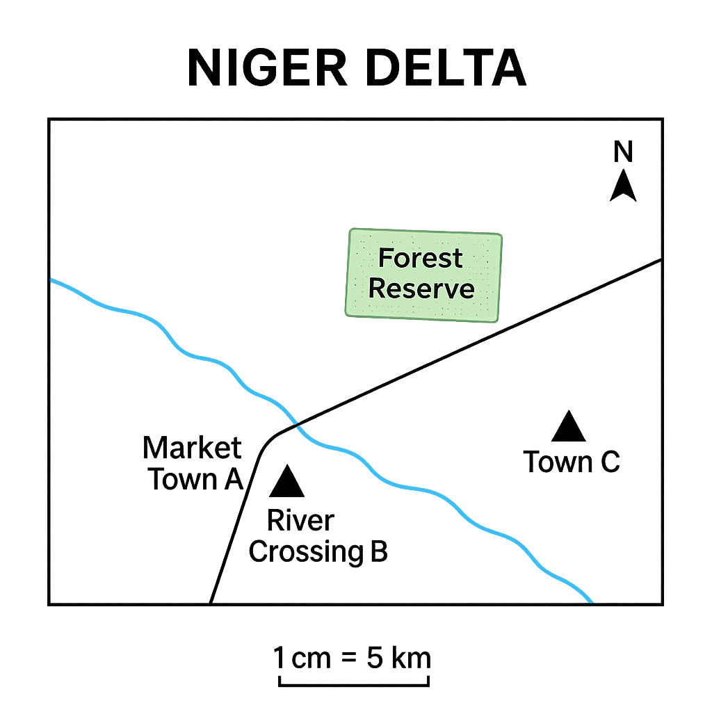
The map below shows part of the Niger Delta region. The map scale is 1 cm : 5 km. The legend indicates that a solid line represents a primary road, a blue line a river, green shading a forest reserve, and a triangle symbol a market town. The north arrow points to true north.
Question Parts
(a)
Identify the symbol used for the market town and state two features that can be inferred about its location from the map.
(b)
The distance between Market Town A and River Crossing B measured on the map is 3.6 cm. Calculate the actual ground distance in kilometres. Show your working.
(c)
From the map, the bearing of the road from Town A to Town C is shown as 45° east of north. State the compass bearing (in degrees) that a traveller would follow, and explain how the bearing is interpreted.
(d)
The forest reserve occupies an area that measures 2.5 cm by 1.8 cm on the map. Estimate the actual area in square kilometres, assuming the forest shape is approximately rectangular.
Detailed Essay Solution & Marking Scheme Available

Get the step-by-step mathematical proofs, key points required by examiners, and a comprehensive breakdown from our AI Tutor.

Question 2 View Details
The diagram below is a schematic map of a coastal region showing two towns, Port Alpha and Port Beta, and a lighthouse. The map scale is 1 cm : 2 km. The distance between the two towns measured on the map is 7.5 cm. The lighthouse is located 2.0 cm north and 1.5 cm east of Port Alpha on the map.
Question Parts
(a)
Calculate the actual distance between Port Alpha and Port Beta in kilometres.
(b)
Using the given north and east displacements, determine the straight‑line distance from Port Alpha to the lighthouse in kilometres. Show your method.
(c)
Find the bearing from Port Alpha to the lighthouse expressed as a compass bearing (degrees east of north). (Assume the map is oriented with north at the top.)
(d)
A second map of the same area is drawn at a scale of 1 cm : 4 km. If the distance between the two towns on the second map is measured as 3.8 cm, verify whether the two maps are consistent with each other.
Detailed Essay Solution & Marking Scheme Available

Get the step-by-step mathematical proofs, key points required by examiners, and a comprehensive breakdown from our AI Tutor.

Question 3 View Details
Town A is situated at 5°30' N latitude and 7°45' E longitude. Town B lies due east of Town A and the straight‑line distance between the two towns is 120 km.
Question Parts
(a)
State the latitude of Town B and justify your answer.
(b)
Calculate the longitude of Town B. (Take the mean radius of the Earth as 6 371 km and use the formula \(d = \frac{\pi}{180}\,R\cos\phi\,\Delta\lambda\) where \(d\) is the east‑west distance, \(\phi\) the latitude and \(\Delta\lambda\) the change in longitude in degrees.)
(c)
Explain why the distance represented by one degree of longitude varies with latitude, and calculate the approximate length of one degree of longitude at the latitude of Town A.
Detailed Essay Solution & Marking Scheme Available

Get the step-by-step mathematical proofs, key points required by examiners, and a comprehensive breakdown from our AI Tutor.

Question 4 View Details
The following table shows the daily maximum temperature (°C), minimum temperature (°C) and rainfall (mm) recorded at Lagos over a consecutive seven‑day period. | Day | Max (°C) | Min (°C) | Rainfall (mm) | |-----|----------|----------|---------------| | 1 | 33 | 26 | 0 | | 2 | 35 | 27 | 5 | | 3 | 34 | 25 | 12 | | 4 | 32 | 24 | 0 | | 5 | 31 | 23 | 0 | | 6 | 30 | 22 | 8 | | 7 | 31 | 24 | 0 |
Question Parts
(a)
Calculate the mean daily temperature for the week. (Mean daily temperature = (Max + Min)/2 for each day, then average over the seven days.)
(b)
Determine the total rainfall recorded during the week and state the day on which the highest rainfall occurred.
(c)
Identify the day that experienced the greatest diurnal temperature range and explain, using atmospheric concepts, why that range was larger than on the other days.
(d)
Discuss two atmospheric processes that could account for the overall pattern of decreasing temperatures and intermittent rainfall observed over the week.
Detailed Essay Solution & Marking Scheme Available

Get the step-by-step mathematical proofs, key points required by examiners, and a comprehensive breakdown from our AI Tutor.

Question 5 View Details
The table below shows the average monthly temperature (°C) and total monthly rainfall (mm) recorded at a weather station in southern Nigeria over a typical year. Month | Temperature (°C) | Rainfall (mm) Jan | 27 | 20 Feb | 28 | 30 Mar | 29 | 80 Apr | 30 | 150 May | 31 | 250 Jun | 30 | 300 Jul | 30 | 320 Aug | 29 | 280 Sep | 28 | 200 Oct | 27 | 120 Nov | 27 | 60 Dec | 27 | 30
Question Parts
(a)
Calculate the mean annual temperature and the total annual rainfall for the station.
(b)
Identify the wet‑season and dry‑season months using a rainfall threshold of 100 mm.
(c)
Using the Köppen climate‑classification criteria, determine the climate type of the station and justify your answer with reference to the calculations and seasonal pattern.
Detailed Essay Solution & Marking Scheme Available

Get the step-by-step mathematical proofs, key points required by examiners, and a comprehensive breakdown from our AI Tutor.

Question 6 View Details
A geologist examined a rock sample collected from a granitic intrusion in the Jos Plateau. Thin‑section microscopy gave the following modal percentages (by volume): - Quartz: 55% - Orthoclase feldspar: 30% - Plagioclase feldspar: 10% - Biotite mica: 5% No other minerals were observed.
Question Parts
(a)
Identify the rock type based on the mineral composition and explain the reasoning.
(b)
Describe the geological processes that lead to the formation of this rock type, including the source of its minerals and the environment of crystallisation.
Detailed Essay Solution & Marking Scheme Available

Get the step-by-step mathematical proofs, key points required by examiners, and a comprehensive breakdown from our AI Tutor.

Question 7 View Details
A region in Nigeria exhibits three distinct landforms – a plateau, a cuesta and an inselberg. Using your knowledge of geomorphology, answer the following.
Question Parts
(a)
Describe the geological and climatic processes that lead to the formation of each of the three landforms (plateau, cuesta and inselberg) in the Nigerian context.
(b)
Compare the geomorphological characteristics of the plateau, cuesta and inselberg with respect to slope, elevation and rock exposure.
(c)
Evaluate how each landform influences patterns of human settlement, agriculture and infrastructure development in the region.
Detailed Essay Solution & Marking Scheme Available

Get the step-by-step mathematical proofs, key points required by examiners, and a comprehensive breakdown from our AI Tutor.

Question 8 View Details
A river basin in Nigeria covers an area of 250 km². The mapped stream network consists of a main river that is 30 km long and five tributaries with lengths of 12 km, 8 km, 5 km, 4 km and 2 km respectively. The river rises in a granitic highland, traverses a zone of shale, and finally discharges onto a coastal plain. Answer the following questions.
Question Parts
(a)
Calculate the drainage density of the basin. Show all steps of your calculation.
(b)
Discuss how the change in lithology from granitic highland to shale influences the longitudinal profile and channel pattern of the river.
(c)
Using the drainage density obtained in part (a), analyse the likely flood response of the basin during a high‑intensity storm. Provide at least two reasons linked to the drainage characteristics.
(d)
Propose two land‑use management measures that could reduce flood risk in this basin and justify how they would be effective.
Detailed Essay Solution & Marking Scheme Available

Get the step-by-step mathematical proofs, key points required by examiners, and a comprehensive breakdown from our AI Tutor.

Master the Exam!

You've seen a preview, but there are thousands more questions plus AI tutor to break down complex solutions.

Unlock Full Access Available for Android & Windows
Help others prepare! Share this practice hub:
Chat with Support