neco model questions vol1 2022 geography | Essay

Prepare for your exams with neco model questions vol1 questions? Reviewing past/model questions is one of the most effective ways to guarantee a high score. This practice hub features authentic 2022 geography (Essay) questions designed to simulate the real exam environment.

Practice these randomly selected questions to test your readiness.
Question 1 View Details
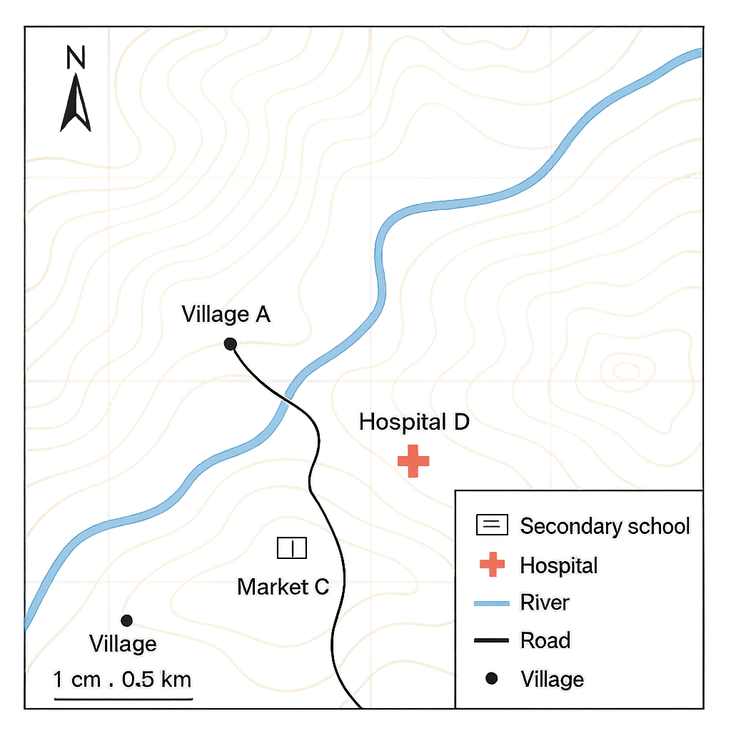
The map shown is a topographic map of a part of a Nigerian state. The map scale is 1 cm : 0.5 km, the contour interval is 20 m and the legend includes symbols for a secondary school, a hospital, a river, a road and a village. The north arrow points to true north. The following points are marked on the map: - Village A at grid coordinate (2 km, 3 km) - River crossing B at (7 km, 8 km) - Market C at (5 km, 2 km) - Hospital D at (9 km, 6 km) - Secondary school S at (6 km, 4 km)
Question Parts
(a)
Identify the symbol used for a secondary school on the legend and state the location of the secondary school on the map.
(b)
Determine the bearing of the straight line from Village A to River crossing B. Express the bearing in the form N°E or as a three‑digit azimuth.
(c)
Estimate the straight‑line distance between Market C and Hospital D. Give your answer in kilometres (to two decimal places) and also state the corresponding distance on the map in centimetres.
(d)
Explain how the contour interval shown on the map can be used to estimate the average slope between two points that are 3 contour lines apart and 1.2 km apart horizontally.
Detailed Essay Solution & Marking Scheme Available

Get the step-by-step mathematical proofs, key points required by examiners, and a comprehensive breakdown from our AI Tutor.
Question 2 View Details
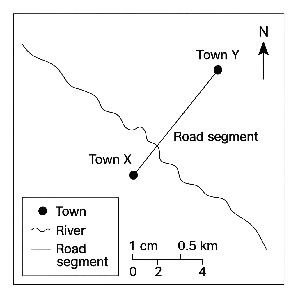
The map shown is a political map of a Nigerian region. The map scale is 1 cm : 0.5 km and a scale bar is provided indicating 0 cm, 2 cm and 4 cm corresponding to 0 km, 1 km and 2 km respectively. The following locations are marked: - Town X at (3 km, 5 km) - Town Y at (10 km, 9 km) - A river segment Z that is measured as 3.5 cm on the map. - A road segment that is measured as 8.0 cm on the map.
Question Parts
(a)
If the distance between Town X and Town Y on the map is 6.0 cm, calculate the actual ground distance in kilometres (to two decimal places).
(b)
The map is re‑scaled to 1 : 25 000 (i.e., 1 cm : 0.25 km). What will be the new map distance in centimetres for the same ground distance found in part (a)?
(c)
The road shown on the map is 8.0 cm long. Estimate the time required to travel the whole road by car travelling at an average speed of 60 km/h. Show all steps.
(d)
Discuss two advantages and two limitations of using a reduced‑scale map for planning a new road network in a rural area.
Detailed Essay Solution & Marking Scheme Available

Get the step-by-step mathematical proofs, key points required by examiners, and a comprehensive breakdown from our AI Tutor.

Question 3 View Details
Lagos is situated at 6°27' N, 3°24' E while Abuja is situated at 9°05' N, 7°29' E.
Question Parts
(a)
Calculate the approximate north‑south distance between Lagos and Abuja. (Use 1° latitude ≈ 111 km.)
(b)
Determine the difference in local solar time between the two cities and explain the reasoning behind your calculation.
(c)
Discuss how the difference in latitude influences the climatic characteristics of Lagos and Abuja. Mention at least two climatic factors.
Detailed Essay Solution & Marking Scheme Available

Get the step-by-step mathematical proofs, key points required by examiners, and a comprehensive breakdown from our AI Tutor.

Question 4 View Details
The table below shows the current weather observations at three stations in the same region. | Station | Latitude (°N) | Longitude (°E) | Temperature (°C) | Pressure (hPa) | Wind Direction | Relative Humidity (%) | |---------|--------------|----------------|-------------------|----------------|----------------|------------------------| | A (Coastal) | 5.0 | 4.0 | 30 | 1008 | From the South-East | 85 | | B (Inland) | 7.5 | 5.5 | 28 | 1005 | From the South-East | 70 | | C (Highland) | 7.5 | 5.5 | 22 | 1002 | From the South-East | 60 | Assume the stations are roughly aligned north‑south and that the wind is steady.
Question Parts
(a)
Identify the type of weather front that is most likely affecting the region and justify your answer using the data in the table.
(b)
Predict the weather conditions (temperature trend, precipitation likelihood and wind change) for the next 24 hours at each station, giving a brief explanation for each prediction.
(c)
Explain how orographic lift contributes to the rainfall pattern observed at Station C compared with Stations A and B.
Detailed Essay Solution & Marking Scheme Available

Get the step-by-step mathematical proofs, key points required by examiners, and a comprehensive breakdown from our AI Tutor.

Question 5 View Details
The table below shows the average monthly temperature (°C) and rainfall (mm) recorded at Jos, Nigeria. | Month | Avg. Temp (°C) | Avg. Rainfall (mm) | |-------|----------------|--------------------| | Jan | 22.5 | 12 | | Feb | 23.0 | 15 | | Mar | 24.5 | 30 | | Apr | 25.0 | 70 | | May | 24.0 | 120 | | Jun | 22.0 | 180 | | Jul | 20.5 | 210 | | Aug | 20.0 | 190 | | Sep | 21.0 | 130 | | Oct | 22.0 | 70 | | Nov | 22.5 | 30 | | Dec | 22.0 | 15 | Using this information, answer the following questions:
Question Parts
(a)
Determine the Köppen climate classification for Jos, clearly showing how the temperature and rainfall data satisfy the criteria for the identified class.
(b)
Explain the seasonal variation in temperature and rainfall for Jos, linking the pattern to the movement of the Intertropical Convergence Zone (ITCZ) and the city’s altitude.
(c)
Discuss two major implications of Jos’s climate for agricultural practices in the region.
Detailed Essay Solution & Marking Scheme Available

Get the step-by-step mathematical proofs, key points required by examiners, and a comprehensive breakdown from our AI Tutor.

Question 6 View Details
A geologist surveys a region where three distinct rock outcrops are observed: (i) A coarse‑grained, pinkish rock with visible interlocking quartz and feldspar crystals. (ii) A dark, fine‑grained rock that splits easily into thin, parallel layers. (iii) A black, glassy rock containing numerous vesicles (small cavities). Answer the following questions:
Question Parts
(a)
Identify the rock type represented by each outcrop (i, ii, iii) and state the typical geological environment in which each forms.
(b)
For the rock identified in (i), describe its cooling history (intrusive versus extrusive) and explain how its texture supports this interpretation.
(c)
The region is being considered for a quarry to supply construction aggregate. Evaluate the suitability of each of the three rocks for this purpose, discussing durability, strength and resistance to weathering.
Detailed Essay Solution & Marking Scheme Available

Get the step-by-step mathematical proofs, key points required by examiners, and a comprehensive breakdown from our AI Tutor.

Question 7 View Details
The state of Plateau in Nigeria exhibits a variety of landforms that result from both tectonic and erosional processes.
Question Parts
(a)
Identify three major landforms found in Plateau State and describe the geological processes responsible for their formation.
(b)
Discuss how each of these landforms influences the pattern of human settlement and the type of agricultural activities practiced in the state.
(c)
Evaluate two major environmental challenges that arise from these landforms and recommend appropriate mitigation measures.
Detailed Essay Solution & Marking Scheme Available

Get the step-by-step mathematical proofs, key points required by examiners, and a comprehensive breakdown from our AI Tutor.

Question 8 View Details
The Benue River basin, which drains a large part of central Nigeria, originates at an elevation of about 800 m above sea level and empties into the Niger River at an elevation of 100 m. The total length of the river from source to mouth is approximately 250 km. The basin experiences a marked seasonal variation in rainfall, with a pronounced wet season from April to October.
Question Parts
(a)
Calculate the average longitudinal gradient of the Benue River in the basin and comment on what this gradient indicates about the river’s energy and sediment‑transport capacity.
(b)
Explain how the drainage pattern of the Benue River influences soil fertility in its floodplain and the implications for agricultural productivity.
(c)
Propose two sustainable water‑management strategies that could be adopted in the basin to cope with the seasonal variability of flow while protecting downstream users.
Detailed Essay Solution & Marking Scheme Available

Get the step-by-step mathematical proofs, key points required by examiners, and a comprehensive breakdown from our AI Tutor.

Master the Exam!

You've seen a preview, but there are thousands more questions plus AI tutor to break down complex solutions.

Unlock Full Access Available for Android & Windows
Help others prepare! Share this practice hub:
Chat with Support