neco model questions vol1 2021 geography | Essay

Prepare for your exams with neco model questions vol1 questions? Reviewing past/model questions is one of the most effective ways to guarantee a high score. This practice hub features authentic 2021 geography (Essay) questions designed to simulate the real exam environment.

Practice these randomly selected questions to test your readiness.
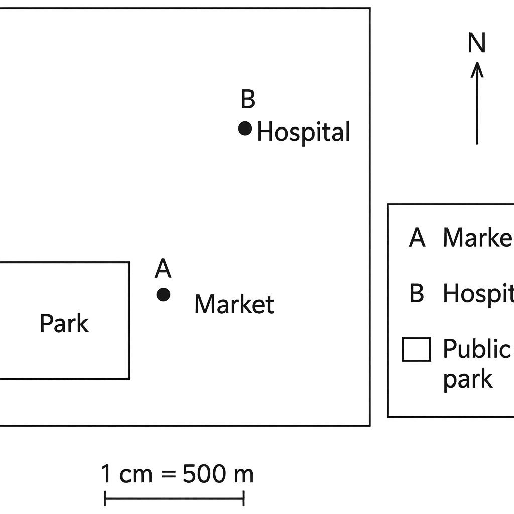
Question 1 View Details
A simplified map of Riverine Town is drawn at a scale of 1 cm = 500 m. The map shows the following points measured from the origin of the map (the south‑west corner): - Point A (the market) is 2 cm east and 3 cm north of the origin. - Point B (the hospital) is 8 cm east and 7 cm north of the origin. - The park occupies a rectangular area on the map whose length is 3 cm (east‑west) and width is 2 cm (north‑south).
Question Parts
(a)
Calculate the straight‑line distance between the market and the hospital on the ground, giving your answer in kilometres (km) to one decimal place.
(b)
State the bearing of the hospital from the market, expressed as a three‑digit bearing (to the nearest degree).
(c)
Determine the actual area of the park in hectares (ha). (1 ha = 10 000 m²)
Detailed Essay Solution & Marking Scheme Available

Get the step-by-step mathematical proofs, key points required by examiners, and a comprehensive breakdown from our AI Tutor.
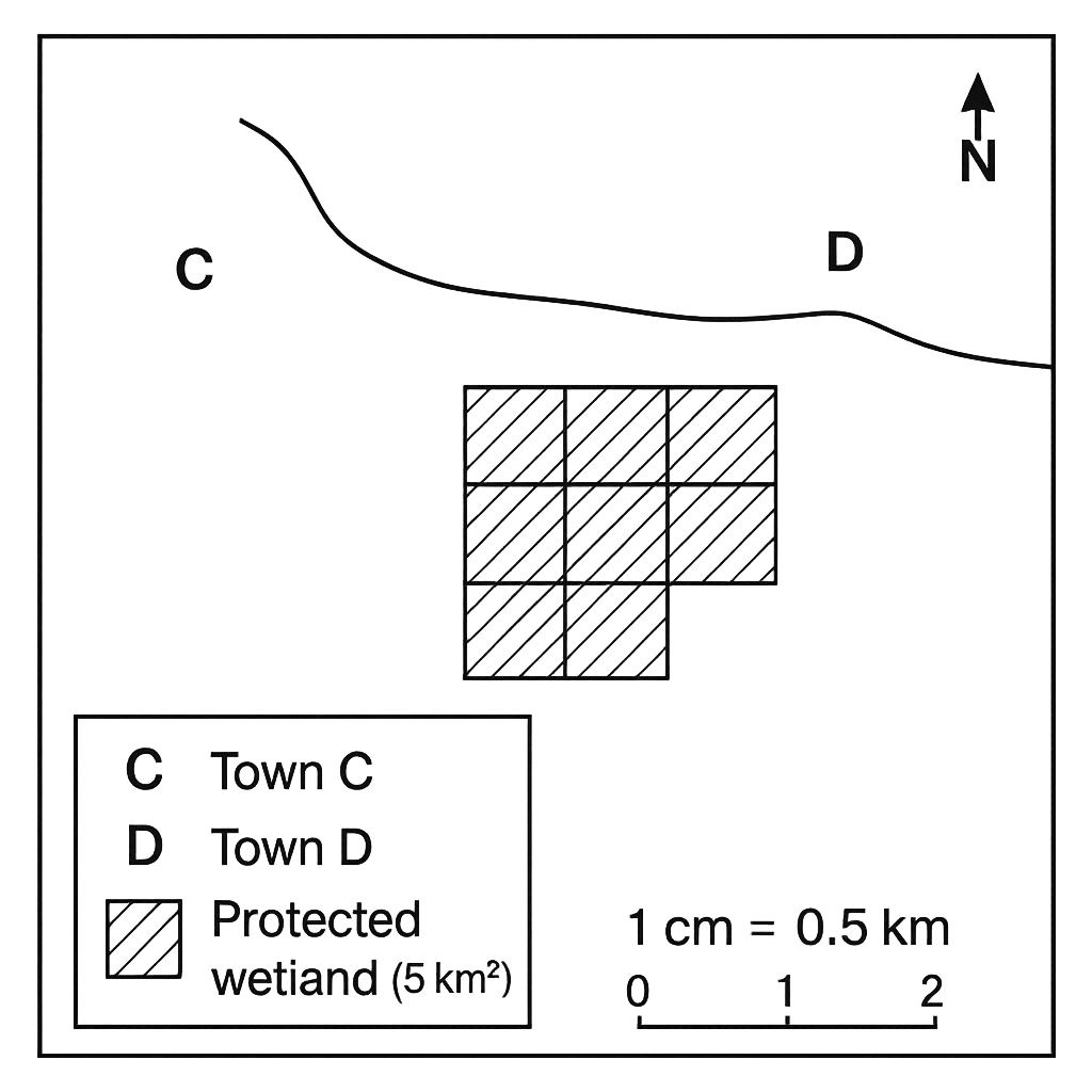
Question 2 View Details
A topographic map of the coastal district is drawn at a scale of 1 : 50 000 (i.e., 1 cm on the map represents 0.5 km on the ground). On the map the following are shown: - Town C is located at the north‑west corner of the map. - Town D lies 9 cm directly east of Town C. - A protected wetland is represented by a shaded region covering five 1‑km² grid squares. - The map also contains a scale bar marked in centimetres. Assume a vehicle can travel on the road between the two towns at a constant speed of 60 km/h.
Question Parts
(a)
Calculate the actual distance between Town C and Town D in kilometres, giving your answer to one decimal place.
(b)
If a vehicle travels from Town C to Town D at 60 km/h, how many minutes will the journey take? (Give the answer to the nearest minute.)
(c)
State the total area of the wetland in square kilometres.
(d)
If a student mistakenly reads the map scale as 1 : 40 000 (i.e., 1 cm = 0.4 km), what would be the erroneous ground distance obtained for the 9‑cm separation, and what percentage error does this represent relative to the correct distance?
Detailed Essay Solution & Marking Scheme Available

Get the step-by-step mathematical proofs, key points required by examiners, and a comprehensive breakdown from our AI Tutor.

Question 3 View Details
The city of Kano lies at 12°00'N, 8°30'E while the city of Lagos is situated at 6°30'N, 3°20'E. Using the fact that 1° of latitude corresponds to approximately 111 km and that the length of a degree of longitude equals 111 km × cos(latitude), answer the following:
Question Parts
(a)
Calculate the approximate straight‑line distance between Kano and Lagos.
(b)
Determine the initial bearing (azimuth) from Kano to Lagos using the tangent formula tan θ = Δλ·cos(average latitude) / Δφ.
(c)
Explain how the difference in latitude between the two cities influences their climatic characteristics.
Detailed Essay Solution & Marking Scheme Available

Get the step-by-step mathematical proofs, key points required by examiners, and a comprehensive breakdown from our AI Tutor.

Question 4 View Details
A weather station recorded the following observations on a clear day: | Time | Temperature (°C) | Relative Humidity (%) | Wind Speed (km/h) | |------|------------------|-----------------------|-------------------| | 06:00 | 22 | 85 | 12 | | 12:00 | 31 | 55 | 18 | | 18:00 | 27 | 70 | 14 | Using the data above, answer the questions that follow:
Question Parts
(a)
Explain the diurnal variation of temperature and relative humidity observed, linking the changes to solar heating and atmospheric processes.
(b)
Using the approximate Magnus formula, estimate the dew‑point temperature at 12:00. The formula is: Td ≈ T – ((100 – RH)/5), where T is temperature in °C and RH is relative humidity in percent.
(c)
Discuss how the wind speed variation throughout the day could influence the perceived temperature (wind chill) and the likelihood of cloud formation in the late afternoon.
(d)
Based on the data, recommend appropriate clothing for a person who will be outdoors from 06:00 to 18:00, justifying your suggestion.
Detailed Essay Solution & Marking Scheme Available

Get the step-by-step mathematical proofs, key points required by examiners, and a comprehensive breakdown from our AI Tutor.

Question 5 View Details
The table below gives the average monthly rainfall (in millimetres) and the average monthly temperature (in °C) recorded over a 10‑year period for a coastal town in southern Nigeria. | Month | Rainfall (mm) | Temperature (°C) | |-------|---------------|------------------| | Jan | 12 | 28.5 | | Feb | 15 | 28.8 | | Mar | 45 | 28.2 | | Apr | 110 | 27.9 | | May | 210 | 27.5 | | Jun | 320 | 27.0 | | Jul | 380 | 26.8 | | Aug | 340 | 27.1 | | Sep | 210 | 27.4 | | Oct | 95 | 27.8 | | Nov | 30 | 28.2 | | Dec | 15 | 28.4 | Using this information, answer the following questions:
Question Parts
(a)
Identify the months that constitute the wet season and the dry season in this locality.
(b)
Explain two atmospheric factors that cause the observed seasonal rainfall pattern in this coastal region.
(c)
Discuss how the seasonal temperature variation influences agricultural activities in the area, giving two specific examples of crops or practices.
Detailed Essay Solution & Marking Scheme Available

Get the step-by-step mathematical proofs, key points required by examiners, and a comprehensive breakdown from our AI Tutor.

Question 6 View Details
A geologist surveys a region where three distinct rock types are exposed. The observations are as follows: (i) A coarse‑grained, light‑coloured rock containing visible quartz grains and feldspar crystals. (ii) A fine‑grained, dark rock that is foliated and shows mineral alignment. (iii) A massive, glassy black rock that lacks crystal faces and is associated with a vein of copper mineralisation. Answer the questions that follow:
Question Parts
(a)
Classify each rock (i, ii, iii) as igneous, sedimentary or metamorphic, giving a brief justification for each classification.
(b)
For the igneous rock identified in part (i), describe the cooling history (intrusive versus extrusive) that would produce its observed texture, and relate this to its mineral composition.
(c)
Considering the three rocks, compare their susceptibility to chemical weathering and indicate which rock is most likely to form a prominent ridge or escarpment, explaining why.
Detailed Essay Solution & Marking Scheme Available

Get the step-by-step mathematical proofs, key points required by examiners, and a comprehensive breakdown from our AI Tutor.

Question 7 View Details
A large dissected plateau occupies the northern part of the Jos Plateau region in Nigeria. The plateau has an average elevation of about 1,300 m above sea level, is cut by deep valleys, and is underlain by Precambrian granitic rocks. The area receives a mean annual rainfall of 1,200 mm, with a distinct wet season from May to October. The local government is considering the construction of a medium‑sized hydro‑electric dam on one of the major streams draining the plateau.
Question Parts
(a)
Explain the geological processes that lead to the formation of a dissected plateau such as the Jos Plateau.
(b)
Discuss how the presence of the plateau influences the local climate and agricultural practices in its immediate surroundings.
(c)
The proposed dam will have a storage capacity of 45 million m³ and will generate approximately 12 MW of electricity. Evaluate the advantages and disadvantages of constructing the dam on this plateau and recommend whether the project should proceed, giving reasons linked to the plateau’s physical geography.
Detailed Essay Solution & Marking Scheme Available

Get the step-by-step mathematical proofs, key points required by examiners, and a comprehensive breakdown from our AI Tutor.

Question 8 View Details
The River Benue, a major tributary of the Niger River, drains a catchment area of approximately 250 km² in the middle belt of Nigeria. The region receives a mean annual rainfall of 1,200 mm, with 70 % of the rainfall occurring during the wet season (May–October). The runoff coefficient for the catchment is estimated at 0.45, and the average annual evapotranspiration loss is 550 mm. The river exhibits a youthful profile in its upper reaches and a mature profile downstream.
Question Parts
(a)
Calculate the mean annual runoff volume (in million cubic metres) contributed by the catchment to the River Benue.
(b)
Discuss two major implications of the calculated runoff volume for flood management in the downstream towns of Makurdi and Onitsha.
(c)
Compare the characteristics of the youthful upper reaches with the mature downstream section of the River Benue, and explain how these characteristics affect the river’s ability to transport sediment.
Detailed Essay Solution & Marking Scheme Available

Get the step-by-step mathematical proofs, key points required by examiners, and a comprehensive breakdown from our AI Tutor.

Master the Exam!

You've seen a preview, but there are thousands more questions plus AI tutor to break down complex solutions.

Unlock Full Access Available for Android & Windows
Help others prepare! Share this practice hub:
Chat with Support