neco 2025 geography | Essay

Prepare for your exams with neco questions? Reviewing past/model questions is one of the most effective ways to guarantee a high score. This practice hub features authentic 2025 geography (Essay) questions designed to simulate the real exam environment.

Practice these randomly selected questions to test your readiness.
Question 1 View Details
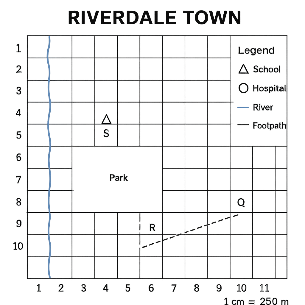
The map of Riverdale Town is drawn on a 10 × 10 grid. Each grid square represents 1 cm on the map and the scale is 1 cm = 250 m. The legend shows that a triangle represents a school, a circle a hospital, a blue line a river and a dashed line a footpath. The following points are marked on the map: - School (S) at grid coordinate (4,5) - Hospital (H) at grid coordinate (8,8) - Footpath start point (P) at (2,9) and end point (Q) at (9,4) - River forms the western boundary of a rectangular park whose opposite corners are at R (3,2) and T (7,5). Using this map answer the questions that follow.
Question Parts
(a)
Determine the straight‑line distance between the school (S) and the hospital (H). Give your answer in kilometres (km) to two decimal places.
(b)
Find the bearing of the footpath from point P to point Q. Express the bearing as a three‑digit angle measured clockwise from true north.
(c)
The rectangular park has its opposite corners at R (3,2) and T (7,5). Calculate the real area of the park in hectares (ha). (1 ha = 10 000 m²)
(d)
A new road is proposed to join the school (S) to the centre of the park. Estimate the length of this road in kilometres and discuss two possible advantages the road would bring to the community.
Detailed Essay Solution & Marking Scheme Available

Get the step-by-step mathematical proofs, key points required by examiners, and a comprehensive breakdown from our AI Tutor.

Question 2 View Details
A map of Lagos District is drawn on a 12 × 12 grid. The scale is 1 cm = 0.5 km (i.e., 1 cm on the map represents 500 m on the ground). The legend indicates that a solid line denotes a major road, a blue shading denotes a lake, and a cross marks the district headquarters. The following locations are shown: - Town X at grid coordinate (3,4) - Town Y at grid coordinate (10,9) - The district headquarters (H) at (6,6) - An irregular lake covering approximately 18 whole grid squares. - A rectangular agricultural field with opposite corners at A (2,2) and B (6,6). A straight line drawn between Town X and Town Y measures 9.2 cm on the map. Using this map answer the following questions.
Question Parts
(a)
Calculate the real straight‑line distance between Town X and Town Y in kilometres, correct to one decimal place.
(b)
Determine the real area of the rectangular agricultural field in hectares (1 ha = 10 000 m²).
Detailed Essay Solution & Marking Scheme Available

Get the step-by-step mathematical proofs, key points required by examiners, and a comprehensive breakdown from our AI Tutor.

Question 3 View Details
City X is situated at 5°N latitude and 7°E longitude, while City Y lies on the same latitude (5°N) but at 13°E longitude. A commercial flight departs from City X at 09:00 local time and flies directly east to City Y with a scheduled flight time of 2 hours 30 minutes, not accounting for any time‑zone differences.
Question Parts
(a)
Calculate the longitudinal difference between the two cities in degrees.
(b)
Using the fact that Earth rotates 360° in 24 hours, determine the time difference (in minutes) between the local solar times of City X and City Y.
(c)
If the flight leaves City X at 09:00 local time, what will be the local time shown on the clock in City Y when the aircraft lands (ignore any daylight‑saving adjustments)?
(d)
Briefly explain why the local solar time differs between the two cities even though they lie on the same latitude.
Detailed Essay Solution & Marking Scheme Available

Get the step-by-step mathematical proofs, key points required by examiners, and a comprehensive breakdown from our AI Tutor.

Question 4 View Details
The table below shows the observed weather data for a coastal town over five consecutive days. | Day | Max Temp (°C) | Min Temp (°C) | Relative Humidity (%) | Wind Direction | |-----|---------------|---------------|-----------------------|----------------| | 1 | 32 | 24 | 78 | South‑East | | 2 | 34 | 25 | 82 | South‑East | | 3 | 31 | 23 | 75 | South‑East | | 4 | 33 | 24 | 80 | South‑East | | 5 | 35 | 26 | 85 | South‑East | Assume the town lies within the tropical zone and is influenced by the nearby ocean.
Question Parts
(a)
Identify the prevailing wind direction for the period and discuss how this wind pattern is likely to affect the amount of rainfall the town receives.
(b)
Based on the temperature and humidity data, classify the town’s climate type (using the Köppen classification) and justify your choice.
(c)
Observe the trend in the data and predict the likely weather (max temperature, min temperature and relative humidity) for Day 6, providing a brief justification for each predicted value.
(d)
Explain why coastal tropical towns often experience smaller diurnal temperature ranges compared with inland locations, using the data above as an illustration.
Detailed Essay Solution & Marking Scheme Available

Get the step-by-step mathematical proofs, key points required by examiners, and a comprehensive breakdown from our AI Tutor.

Question 5 View Details
The table below shows the average monthly temperature (°C) and average monthly rainfall (mm) recorded for the coastal city of Lagos over a twelve‑month period. Month | Jan | Feb | Mar | Apr | May | Jun | Jul | Aug | Sep | Oct | Nov | Dec --- | --- | --- | --- | --- | --- | --- | --- | --- | --- | --- | --- | --- Temperature (°C) | 27 | 28 | 29 | 30 | 30 | 28 | 27 | 27 | 28 | 29 | 28 | 27 Rainfall (mm) | 30 | 45 | 70 | 120 | 200 | 250 | 300 | 280 | 250 | 150 | 80 | 40
Question Parts
(a)
Calculate the mean annual temperature and the mean annual rainfall for Lagos. Show all working steps.
(b)
Identify the two months that receive the highest rainfall and explain, using the data, how the pattern of rainfall influences the climate classification of Lagos.
(c)
Discuss three major factors—physical or human—that affect the climate of Lagos, linking each factor to the data provided.
Detailed Essay Solution & Marking Scheme Available

Get the step-by-step mathematical proofs, key points required by examiners, and a comprehensive breakdown from our AI Tutor.

Question 6 View Details
A field geologist collected three rock samples from different locations on the Jos Plateau. The observations for each sample are recorded below. Sample A: coarse‑grained, interlocking crystals visible to the naked eye; contains quartz, feldspar and mica; hardness 7 on Mohs scale; effervesces weakly with dilute hydrochloric acid. Sample B: fine‑grained, thinly layered; feels soft; contains clay minerals; no reaction with acid. Sample C: black, glassy, vesicular texture; density noticeably high; no visible crystals; does not react with acid.
Question Parts
(a)
Identify the rock type of each sample (igneous, sedimentary or metamorphic) and justify your identification using the observations provided.
(b)
For the coarse‑grained igneous sample (Sample A), determine whether it is intrusive or extrusive and explain the reasoning.
(c)
Discuss how weathering and erosion of the sedimentary sample (Sample B) contribute to the formation of soil in the Jos Plateau, linking your discussion to the rock’s properties.
Detailed Essay Solution & Marking Scheme Available

Get the step-by-step mathematical proofs, key points required by examiners, and a comprehensive breakdown from our AI Tutor.

Question 7 View Details
The coastal region of Nigeria exhibits a variety of landforms resulting from both tectonic and erosional processes.
Question Parts
(a)
Describe the processes that lead to the formation of each of the following coastal landforms in Nigeria:
() Wave‑cut platform
() Sea cliff
() Coastal dune
(b)
Based on their physical characteristics, evaluate which of the three landforms is most vulnerable to sea‑level rise and justify your choice.
(c)
Suggest two sustainable management strategies to mitigate coastal erosion of the landform identified in part (b). Explain briefly how each strategy works.
Detailed Essay Solution & Marking Scheme Available

Get the step-by-step mathematical proofs, key points required by examiners, and a comprehensive breakdown from our AI Tutor.

Question 8 View Details
A map of the River Benue basin in Nigeria shows a dendritic drainage pattern with several tributaries, varying slopes, and a central floodplain.
Question Parts
(a)
Explain why a dendritic pattern predominates in this basin, linking it to underlying geology and topography.
(b)
Calculate the average gradient (slope) of the main river, given that the source is at an elevation of 1,200 m, the mouth at 150 m, and the river length is 1,650 km. Show your working.
(c)
Discuss two factors that influence the river’s discharge variability during the rainy season, and suggest one engineering measure to reduce flood risk in the floodplain.
Detailed Essay Solution & Marking Scheme Available

Get the step-by-step mathematical proofs, key points required by examiners, and a comprehensive breakdown from our AI Tutor.

Master the Exam!

You've seen a preview, but there are thousands more questions plus AI tutor to break down complex solutions.

Unlock Full Access Available for Android & Windows
Help others prepare! Share this practice hub:
Chat with Support