neco 2022 geography | Essay

Prepare for your exams with neco questions? Reviewing past/model questions is one of the most effective ways to guarantee a high score. This practice hub features authentic 2022 geography (Essay) questions designed to simulate the real exam environment.

Practice these randomly selected questions to test your readiness.
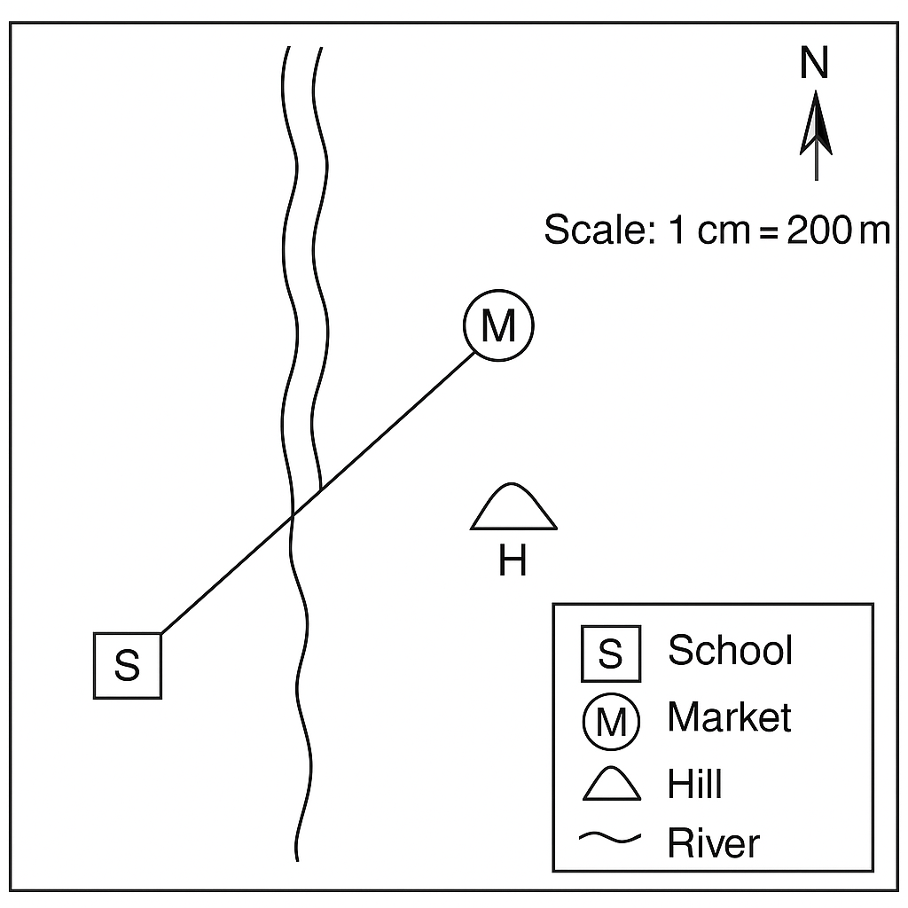
Question 1 View Details
The map below shows a small community. The scale is 1 cm = 200 m. The north arrow points upwards. The legend identifies the symbols: S – School, M – Market, H – Hill, R – River (a north‑south river). The school (S) is located at the origin of the map. The market (M) is 3 cm east and 4 cm north of the school. The hill (H) is 5 cm east and 1 cm south of the school. A straight road connects the school and the market. Answer the following:
Question Parts
(a)
State the bearing of the road from the school to the market.
(b)
Calculate the actual distance between the school and the market in metres.
(c)
A new road is to be built directly from the school to the hill. State the approximate bearing of this road and the actual distance in metres.
Detailed Essay Solution & Marking Scheme Available

Get the step-by-step mathematical proofs, key points required by examiners, and a comprehensive breakdown from our AI Tutor.

Question 2 View Details
The map below shows two towns, A and B, linked by a straight road. The scale of the map is 1 cm = 0.5 km. The towns are 7.5 cm apart on the map along a horizontal line. A river runs between the towns, and a bridge (C) is located 2 cm from town A along the same line. The map also indicates that the river follows a gentle curve approximated by a semicircle whose diameter is the straight line AB. Answer the following:
Question Parts
(a)
Determine the actual distance between towns A and B in kilometres.
(b)
If a new road is to be constructed following the river’s curvature (approximated as a semicircle with diameter AB), estimate the length of this road in kilometres (use π ≈ 3.14).
(c)
Discuss two advantages of using a larger‑scale map (e.g., 1 cm = 0.2 km) for planning local infrastructure such as roads and bridges.
Detailed Essay Solution & Marking Scheme Available

Get the step-by-step mathematical proofs, key points required by examiners, and a comprehensive breakdown from our AI Tutor.

Question 3 View Details
The geographical coordinates of Lagos are 6°27'N, 3°22'E and those of Kano are 12°00'N, 8°31'E.
Question Parts
(a)
Calculate the approximate great‑circle distance between Lagos and Kano using the haversine formula. Take the Earth’s radius as 6371 km.
(b)
Determine the initial bearing (forward azimuth) from Lagos to Kano.
(c)
A flight departs Lagos at 09:00 local time (UTC+1) and flies directly to Kano at an average speed of 800 km h⁻¹. Estimate the arrival time in Kano (local time).
(d)
Briefly discuss two ways in which latitude influences the climate of Nigeria.
Detailed Essay Solution & Marking Scheme Available

Get the step-by-step mathematical proofs, key points required by examiners, and a comprehensive breakdown from our AI Tutor.

Question 4 View Details
The following weather data were recorded for a coastal city in the Niger Delta over a seven‑day period: Maximum temperatures (°C): 30, 32, 31, 33, 34, 35, 33 Minimum temperatures (°C): 24, 25, 24, 25, 26, 27, 25 Average relative humidity: 85 % Average wind speed: 12 km h⁻¹ from the southeast.
Question Parts
(a)
Calculate the mean daily temperature for the week.
(b)
Determine the temperature range (maximum minus minimum) recorded during the week.
Detailed Essay Solution & Marking Scheme Available

Get the step-by-step mathematical proofs, key points required by examiners, and a comprehensive breakdown from our AI Tutor.

Question 5 View Details
The table below shows the average monthly temperature (°C) and average monthly rainfall (mm) for two towns located at the same latitude (7°N). Town A lies on the coast, while Town B is situated 500 km inland. | Month | Town A Temp (°C) | Town A Rainfall (mm) | Town B Temp (°C) | Town B Rainfall (mm) | |-------|------------------|----------------------|------------------|----------------------| | Jan | 28 | 300 | 30 | 80 | | Feb | 28 | 280 | 30 | 70 | | Mar | 27 | 250 | 29 | 60 | | Apr | 27 | 220 | 28 | 50 | | May | 26 | 200 | 27 | 40 | | Jun | 26 | 180 | 26 | 30 | | Jul | 25 | 150 | 26 | 20 | | Aug | 25 | 150 | 26 | 20 | | Sep | 26 | 180 | 27 | 30 | | Oct | 27 | 200 | 28 | 50 | | Nov | 27 | 250 | 29 | 70 | | Dec | 28 | 280 | 30 | 80 | Answer the following questions:
Question Parts
(a)
Identify the Köppen climate type of each town and give a brief justification based on the data.
(b)
Explain two geographical factors that account for the difference in rainfall between the two towns.
(c)
Discuss how the climate of Town A influences the type of agricultural practices likely to be found in its surrounding area.
Detailed Essay Solution & Marking Scheme Available

Get the step-by-step mathematical proofs, key points required by examiners, and a comprehensive breakdown from our AI Tutor.

Question 6 View Details
A geologist collects three rock samples from a region that exhibits varied terrain. Sample X: Coarse‑grained, light‑coloured rock with visible quartz and feldspar crystals. Sample Y: Fine‑grained, dark rock that breaks easily into thin sheets. Sample Z: Hard, dark rock with interlocking crystals of pyroxene and plagioclase. Answer the following questions:
Question Parts
(a)
Identify the rock type (igneous, sedimentary or metamorphic) for each sample, providing a brief justification for each identification.
(b)
Explain the processes that could have led to the formation of Sample Y, including the original rock type and the metamorphic conditions required.
(c)
Discuss the significance of the rock cycle in shaping the landscape of the region, linking your discussion to the three samples.
Detailed Essay Solution & Marking Scheme Available

Get the step-by-step mathematical proofs, key points required by examiners, and a comprehensive breakdown from our AI Tutor.

Question 7 View Details
Nigeria exhibits a variety of landforms that influence its climate, vegetation and patterns of human settlement.
Question Parts
(a)
Identify three major landforms found in Nigeria and briefly describe the geological processes that gave rise to each of them.
(b)
Explain how the presence of a plateau, such as the Jos Plateau, influences the local climate and agricultural potential of the region.
(c)
Evaluate the advantages and disadvantages of establishing a human settlement on a floodplain compared with a plateau.
Detailed Essay Solution & Marking Scheme Available

Get the step-by-step mathematical proofs, key points required by examiners, and a comprehensive breakdown from our AI Tutor.

Question 8 View Details
A small river basin in the middle belt of Nigeria has the following characteristics for a design storm of 10 minutes duration:
Question Parts
(a)
Given a catchment area of 25 km², a rainfall intensity of 80 mm h⁻¹, and a runoff coefficient of 0.55, calculate the peak discharge (in m³ s⁻¹) using the Rational Method. Show all steps and justify the choice of the runoff coefficient.
(b)
Using the peak discharge obtained in part (a), discuss qualitatively the type of channel cross‑section and roughness coefficient that would be appropriate to convey the flow safely, referring to Manning’s equation where relevant.
(c)
Identify two human activities that could aggravate drainage problems in this basin and propose one engineering or management measure for each activity to mitigate the impact.
Detailed Essay Solution & Marking Scheme Available

Get the step-by-step mathematical proofs, key points required by examiners, and a comprehensive breakdown from our AI Tutor.

Master the Exam!

You've seen a preview, but there are thousands more questions plus AI tutor to break down complex solutions.

Unlock Full Access Available for Android & Windows
Help others prepare! Share this practice hub:
Chat with Support