neco 2021 geography | Objective

Prepare for your exams with neco questions? Reviewing past/model questions is one of the most effective ways to guarantee a high score. This practice hub features authentic 2021 geography (Objective) questions designed to simulate the real exam environment.

Practice these randomly selected questions to test your readiness.

Question 1 View Details
A farmer plans to apply a mixture of two fertilizers, A and B, to meet the minimum nutrient requirements for a 5‑ha field. Fertilizer A contains \(20\%\) N, \(10\%\) P_{2}O_{5} and \(5\%\) K_{2}O by weight; fertilizer B contains \(12\%\) N, \(18\%\) P_{2}O_{5} and \(8\%\) K_{2}O. The field requires at least \(15\) kg of nitrogen, \(12\) kg of P_{2}O_{5} and \(5\) kg of K_{2}O. Fertilizer A costs \(\text{₦}150\) per kg and fertilizer B costs \(\text{₦}120\) per kg. Determine the quantities of fertilizers A and B (in kg) that will satisfy the nutrient requirements at the lowest total cost. Show all steps.
A. Fertilizer A = 45 kg, Fertilizer B = 45 kg
Correct B. Fertilizer A = 52.5 kg, Fertilizer B = 37.5 kg
C. Fertilizer A = 40 kg, Fertilizer B = 50 kg
D. Fertilizer A = 60 kg, Fertilizer B = 30 kg

Correct Answer: B

Want to see the full step-by-step solution? Unlock AI Explanation & Analytics
Question 2 View Details
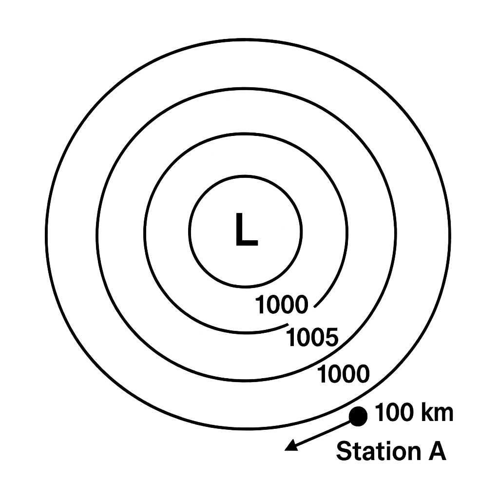
The weather diagram shows three concentric isobars centred on a low‑pressure system L. The outer isobar is 1010 hPa, the middle is 1005 hPa and the innermost is 1000 hPa. Station A is located 100 km due east of L, on the 1005 hPa line. Assuming geostrophic balance, air density \(\rho = 1.2\,\text{kg\,m}^{-3}\) and Coriolis parameter \(f = 1.0\times10^{-4}\,\text{s}^{-1}\), determine (i) the wind direction at station A and (ii) the approximate wind speed in m s\(^{-1}\). Use the pressure difference between the outermost and innermost isobars (10 hPa) over the radial distance of 200 km.
A. Wind blows toward the north; speed ≈ 42 m s⁻¹
Correct B. Wind blows toward the south; speed ≈ 42 m s⁻¹
C. Wind blows toward the south; speed ≈ 30 m s⁻¹
D. Wind blows toward the east; speed ≈ 50 m s⁻¹

Correct Answer: B

Want to see the full step-by-step solution? Unlock AI Explanation & Analytics
Question 3 View Details
A topographic map of a region has a scale of 1 : 50 000. The straight‑line distance between Town X and Town Y measures 3 cm on the map. Calculate the actual ground distance between the two towns in kilometres, correct to one decimal place.
A. 1.3 km
B. 2.0 km
C. 1.8 km
Correct D. 1.5 km

Correct Answer: D

Want to see the full step-by-step solution? Unlock AI Explanation & Analytics
Question 4 View Details
Table 1 gives data for three regions of Nigeria.\n\n| Region | Area (km²) | Population | Avg. annual rainfall (mm) |\n|--------|------------|------------|---------------------------|\n| A | 30 000 | 6 000 000 | 1500 |\n| B | 20 000 | 4 000 000 | 800 |\n| C | 10 000 | 2 000 000 | 1200 |\n\nFor each region compute the index \(I = \dfrac{\text{population}}{\text{area}\times\text{rainfall}}\) (people per km² per mm). Identify the region with the highest index and allocate a water‑resource budget of \(\text{₦}1\,200\,000\) proportionally to the indices. How much budget does the region with the highest index receive? Give your answer in naira, rounded to the nearest naira.
Correct A. 545455
B. 400000
C. 545454
D. 600000

Correct Answer: A

Want to see the full step-by-step solution? Unlock AI Explanation & Analytics
Question 5 View Details
A sedimentary rock sample weighs 1000 kg and has the following mineral composition by weight: quartz 40 %, feldspar 30 %, calcite 20 %, clay minerals 10 %. The silica (SiO₂) content of each mineral is: quartz 100 %, feldspar 65 %, calcite 0 %, clay minerals 45 %. Calculate the overall SiO₂ percentage of the rock.
A. 62
B. 58
Correct C. 64
D. 66

Correct Answer: C

Want to see the full step-by-step solution? Unlock AI Explanation & Analytics
Question 6 View Details
Using the data below, determine which river basin (A, B or C) is expected to incur the highest annual flood damage cost. Basin A: annual rainfall 1200 mm, average slope 5 %, catchment area 250 km², population density 150 persons/km², average household size 5 persons, average property value per household ₦2,000,000. Basin B: annual rainfall 900 mm, average slope 8 %, catchment area 180 km², population density 200 persons/km², average household size 4 persons, average property value per household ₦1,500,000. Basin C: annual rainfall 1100 mm, average slope 6 %, catchment area 300 km², population density 120 persons/km², average household size 5 persons, average property value per household ₦2,500,000. The probability of flooding for a basin is estimated by \( P = \frac{R \times S}{10{,}000 \times A} \) where \(R\) is rainfall (mm), \(S\) is slope (%), and \(A\) is catchment area (km²). Expected annual damage = \( P \times (\text{total property value}) \). Identify the basin with the greatest expected damage.
A. Basin C
B. Basin D
Correct C. Basin B
D. Basin A

Correct Answer: C

Want to see the full step-by-step solution? Unlock AI Explanation & Analytics
Question 7 View Details
Two regions, X and Y, each consist of three altitude zones. The mean annual temperature at sea level for Region X is 30°C and for Region Y is 28°C. The temperature decreases with altitude at the standard lapse rate of 6.5°C per 1000 m. Region X zones: - Zone 1: 40 % of the area, altitude 0 m. - Zone 2: 35 % of the area, altitude 800 m. - Zone 3: 25 % of the area, altitude 1500 m. Region Y zones: - Zone 1: 50 % of the area, altitude 200 m. - Zone 2: 30 % of the area, altitude 1000 m. - Zone 3: 20 % of the area, altitude 1800 m. Calculate the area‑weighted mean annual temperature for each region and state which region has the lower mean temperature.
A. Both regions
B. Region X
C. Region Z
Correct D. Region Y

Correct Answer: D

Want to see the full step-by-step solution? Unlock AI Explanation & Analytics
Question 8 View Details
A state originally had 12,000 km² of forest cover. Over the next five years, the forest loses 2 % of its remaining area each year due to deforestation. Additionally, a reforestation programme adds 150 km² of new forest at the end of every second year (i.e., after years 2 and 4). What is the percentage of the original forest that remains after the five‑year period? Express your answer to one decimal place.
A. 94.2
B. 88.7
Correct C. 92.8
D. 90.5

Correct Answer: C

Want to see the full step-by-step solution? Unlock AI Explanation & Analytics
Question 9 View Details
A steel‑rod manufacturing firm has fixed monthly costs of ₦5,000,000. The variable cost per rod is ₦2,500 and each rod sells for ₦4,000. The government imposes an environmental tax that is tiered: for the first 2,000 rods produced in a month the tax is ₦300 per rod; for any rod above 2,000 the tax rises to ₦500 per rod. What is the minimum number of rods the firm must produce and sell each month to achieve a profit of at least ₦1,000,000?
A. 5400
Correct B. 5600
C. 5800
D. 6000

Correct Answer: B

Want to see the full step-by-step solution? Unlock AI Explanation & Analytics
Question 10 View Details
A map scale is 1 cm : 5 km. The distance between Town A and Town B on the map measures 7.4 cm. What is the actual distance between the two towns in kilometres?
A. 42
Correct B. 37
C. 38
D. 35

Correct Answer: B

Want to see the full step-by-step solution? Unlock AI Explanation & Analytics
Question 11 View Details
Given that the mean annual temperature at sea level for a region is \(30^{\circ}\text{C}\) and that temperature decreases by \(0.6^{\circ}\text{C}\) for every 100 m rise in altitude, a location at 500 m above sea level receives an average annual rainfall of 800 mm. Using the following vegetation thresholds:\n- Tropical rainforest: rainfall > 2000 mm,\n- Savanna: rainfall 500-1500 mm and temperature > 20\,\^{\circ}\text{C},\n- Montane forest: rainfall > 1500 mm and temperature < 20\,\^{\circ}\text{C},\n- Grassland: rainfall < 500 mm.\nIdentify the vegetation type most likely to occur at this location.
A. Grassland
B. Montane forest
C. Tropical rainforest
Correct D. Savanna

Correct Answer: D

Want to see the full step-by-step solution? Unlock AI Explanation & Analytics
Question 12 View Details
A manufacturing firm is evaluating two possible locations for a new plant. The data are as follows:\n\nLocation A:\n- Fixed capital cost: ₦2,000,000 (amortised over 5 years).\n- Variable labour cost per unit: ₦180. Labour tax: 5% of labour cost.\n- Transport cost per km per unit: ₦0.44. Distance to market: 250 km.\n- Labour‑hour requirement per unit: 0.6 h. Annual labour‑hour availability: 6,000 h.\n\nLocation B:\n- Fixed capital cost: ₦5,000,000 (amortised over 5 years).\n- Variable labour cost per unit: ₦200. Labour tax: 10% of labour cost.\n- Transport cost per km per unit: ₦0.20. Distance to market: 150 km.\n- Labour‑hour requirement per unit: 0.6 h. Annual labour‑hour availability: 12,000 h.\n\nThe firm plans to produce either 10,000 units or 20,000 units per year. For each production level, determine which location is more cost‑effective, taking into account total cost per unit and the labour‑availability constraint.
A. Location B for 10,000 units; Location B for 20,000 units
B. Location B for 10,000 units; Location A for 20,000 units
C. Location A for 10,000 units; Location A for 20,000 units
Correct D. Location A for 10,000 units; Location B for 20,000 units

Correct Answer: D

Want to see the full step-by-step solution? Unlock AI Explanation & Analytics
Question 13 View Details
A rock sample is described as having a coarse‑grained interlocking crystal texture, composed of 60 % quartz, 20 % feldspar, 10 % mica and 10 % amphibole. In the field the rock occurs as thick, banded layers alternating light and dark minerals, and it is known to have formed under high pressure and temperature. Based on these characteristics, state the most appropriate rock name.
A. Amphibolite
B. Schist
Correct C. Gneiss
D. Migmatite

Correct Answer: C

Want to see the full step-by-step solution? Unlock AI Explanation & Analytics
Question 14 View Details
The yield of a crop (in tonnes per hectare) as a function of the amount of fertilizer applied \(F\) (kg ha\(^{-1}\)) is given by \(Y(F)= -0.02F^{2}+1.2F+5\) for \(0\le F\le 100\). The market price of the crop is ₦200 per kg, the cost of fertilizer is ₦30 per kg, and the fixed production cost is ₦10,000 per hectare. Determine the fertilizer amount that maximizes profit per hectare and compute the maximum profit.
A. 35 kg ha⁻¹ of fertilizer; maximum profit = ₦4,750,000 per hectare
Correct B. 30 kg ha⁻¹ of fertilizer; maximum profit = ₦4,589,100 per hectare
C. 25 kg ha⁻¹ of fertilizer; maximum profit = ₦4,300,000 per hectare
D. 30 kg ha⁻¹ of fertilizer; maximum profit = ₦4,500,000 per hectare

Correct Answer: B

Want to see the full step-by-step solution? Unlock AI Explanation & Analytics
Question 15 View Details
A soil has a hydraulic conductivity \(K = 2\) cm day\(^{-1}\). The impermeable layer lies 150 cm below the ground surface, and tile drains are to be installed with their centre at 70 cm depth. The desired steady‑state drainage rate is \(q = 0.1\) cm day\(^{-1}\) and the target water‑table depth is 80 cm below the surface. Using Hooghoudt's equation \(L = \sqrt{\dfrac{8KD(D-d)}{q}}\), where \(D\) is the depth to the impermeable layer and \(d\) is the drain depth, calculate the recommended spacing \(L\) between adjacent drains (in metres, rounded to the nearest metre).
A. 12 m
B. 16 m
C. 10 m
Correct D. 14 m

Correct Answer: D

Want to see the full step-by-step solution? Unlock AI Explanation & Analytics
Question 16 View Details
Table: Jan 80, Feb 70, Mar 120, Apr 150, May 200, Jun 250, Jul 300, Aug 280, Sep 220, Oct 160, Nov 110, Dec 90 (mm). (a) Calculate the mean monthly rainfall. (b) Determine the median monthly rainfall (the average of the two middle values when the data are ordered). (c) Using the mean from (a) and the median from (b), the rainfall variability index is defined as \( \text{RVI}=\frac{\text{Mean}-\text{Median}}{\text{Median}}\times100\% \). Compute the RVI to two decimal places. (d) A month is classified as 'wet' if its rainfall exceeds the mean by more than 20\%. How many months are wet?
A. Mean = 170.00 mm; Median = 155 mm; RVI = 9.68%; Wet months = 3
Correct B. Mean = 169.17 mm; Median = 155 mm; RVI = 9.14%; Wet months = 4
C. Mean = 169.17 mm; Median = 160 mm; RVI = 5.73%; Wet months = 5
D. Mean = 165.00 mm; Median = 150 mm; RVI = 10.00%; Wet months = 2

Correct Answer: B

Want to see the full step-by-step solution? Unlock AI Explanation & Analytics
Question 17 View Details
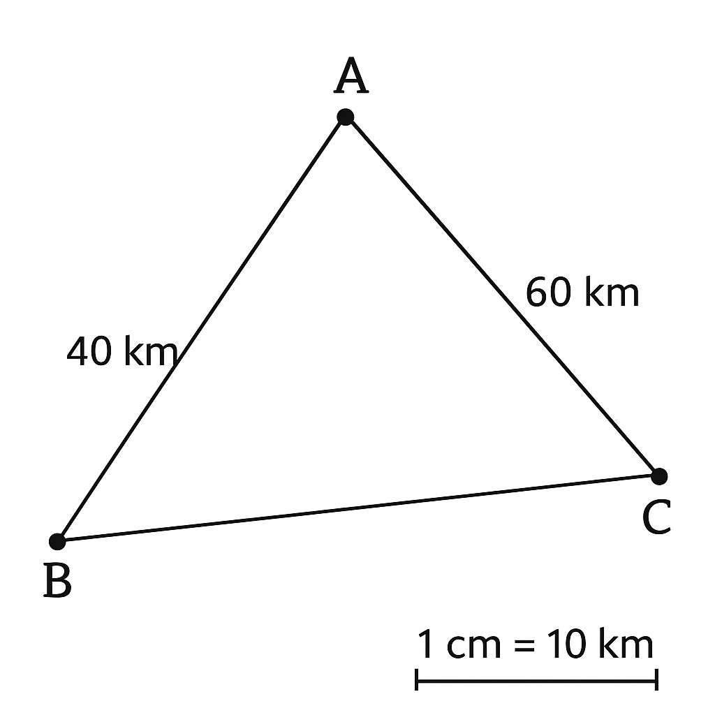
On the map the distance between Town A and Town B is shown as 4 cm and between Town A and Town C as 6 cm. The straight‑line distance between Town B and Town C measures 5 cm on the map. The map scale is 1 cm : 10 km. What is the actual distance between Town B and Town C in kilometres?
A. 60 km
B. 40 km
C. 55 km
Correct D. 50 km

Correct Answer: D

Want to see the full step-by-step solution? Unlock AI Explanation & Analytics
Question 18 View Details
City X lies at latitude 5\degree N, longitude 7\degree E, and City Y lies at latitude 9\degree N, longitude 7\degree E. Assuming the Earth is a sphere with radius 6371 km, calculate the north‑south distance between the two cities in kilometres, rounding to the nearest kilometre.
A. 390 km
B. 470 km
Correct C. 445 km
D. 420 km

Correct Answer: C

Want to see the full step-by-step solution? Unlock AI Explanation & Analytics
Question 19 View Details
A rock sample weighs 250 g. Chemical analysis shows it contains 45\% quartz, 30\% feldspar, 15\% mica and the remainder other minerals. (a) Determine the mass of each mineral present. (b) A rock is classified as granite when quartz \ge 20\%, feldspar \ge 25\% and mica \le 10\%. Does this sample qualify as granite? Justify your answer.
A. Quartz: 112.5 g; Feldspar: 75 g; Mica: 37.5 g; Others: 25 g. The rock is granite because all criteria are met.
B. Quartz: 100 g; Feldspar: 80 g; Mica: 30 g; Others: 40 g. The rock is NOT granite because quartz is below 20\\%.
C. Quartz: 112.5 g; Feldspar: 70 g; Mica: 37.5 g; Others: 30 g. The rock is NOT granite because feldspar is below 25\\%.
Correct D. Quartz: 112.5 g; Feldspar: 75 g; Mica: 37.5 g; Others: 25 g. The rock is NOT granite because mica exceeds 10\%.

Correct Answer: D

Want to see the full step-by-step solution? Unlock AI Explanation & Analytics
Question 20 View Details
A map has a scale of 1 cm : 5 km. The distance between two villages on the map is measured as 7.2 cm. What is the actual distance between the villages in kilometres?
A. 360 km
B. 1.44 km
C. 0.36 km
Correct D. 36 km

Correct Answer: D

Want to see the full step-by-step solution? Unlock AI Explanation & Analytics
Question 21 View Details
A catchment receives a uniform storm delivering \(40\text{ mm}\) of rain over \(3\) hours. The soil infiltration capacity is \(12\text{ mm hr}^{-1}\) for the first \(2\) hours and \(6\text{ mm hr}^{-1}\) thereafter. If the catchment area is \(1.5\text{ km}^{2}\), calculate the total runoff depth and the runoff volume.
A. Runoff depth = 4 mm; Runoff volume = 6,000 m³
B. Runoff depth = 12 mm; Runoff volume = 18,000 m³
C. Runoff depth = 22 mm; Runoff volume = 33,000 m³
Correct D. Runoff depth = 10 mm; Runoff volume = 15,000 m³

Correct Answer: D

Want to see the full step-by-step solution? Unlock AI Explanation & Analytics
Question 22 View Details
Using the Köppen classification, determine the climate type (first two letters) for a location with total annual precipitation \(1200\text{ mm}\) and a driest month rainfall of \(30\text{ mm}\). The threshold for a tropical savanna (Aw) is given by \(100 - \frac{P_{annual}}{25}\) mm.
A. Cw
B. Af
C. Am
Correct D. Aw

Correct Answer: D

Want to see the full step-by-step solution? Unlock AI Explanation & Analytics
Question 23 View Details
An air parcel at sea level has temperature \(30^{\circ}\text{C}\) and dew‑point \(20^{\circ}\text{C}\). It rises dry adiabatically at \(9.8^{\circ}\text{C km}^{-1}\) until saturation, then moist adiabatically at \(6^{\circ}\text{C km}^{-1}\). (i) Find the altitude of the cloud base (LCL) using \(\text{LCL (m)} = 125\,(T - T_d)\). (ii) Determine the parcel temperature at an altitude of \(2\text{ km}\).
Correct A. Cloud base = 1250 m; Temperature at 2 km ≈ 13.3°C
B. Cloud base = 1000 m; Temperature at 2 km ≈ 12.5°C
C. Cloud base = 1500 m; Temperature at 2 km ≈ 13.3°C
D. Cloud base = 1250 m; Temperature at 2 km ≈ 15.0°C

Correct Answer: A

Want to see the full step-by-step solution? Unlock AI Explanation & Analytics
Question 24 View Details
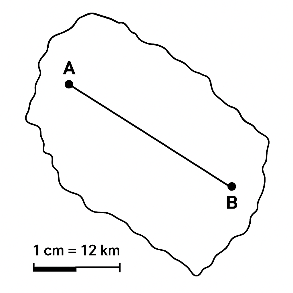
The map shows towns A and B separated by \(7.5\text{ cm}\). The map scale is \(1\text{ cm} : 12\text{ km}\). Find the actual distance between the towns.
Correct A. 90 km
B. 75 km
C. 108 km
D. 84 km

Correct Answer: A

Want to see the full step-by-step solution? Unlock AI Explanation & Analytics
Question 25 View Details
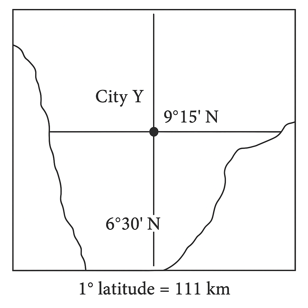
City X lies at latitude \(6^{\circ}30' \text{ N}\) and City Y at \(9^{\circ}15' \text{ N}\). Each degree of latitude corresponds to \(111\text{ km}\). Calculate the north‑south distance between the two cities.
Correct A. Approximately 305 km
B. Approximately 280 km
C. Approximately 320 km
D. Approximately 350 km

Correct Answer: A

Want to see the full step-by-step solution? Unlock AI Explanation & Analytics

Master the Exam!

You've seen a preview, but there are thousands more questions plus AI tutor to break down complex solutions.

Unlock Full Access Available for Android & Windows
Help others prepare! Share this practice hub:
Chat with Support