gce model questions vol1 2025 geography | Essay

Prepare for your exams with gce model questions vol1 questions? Reviewing past/model questions is one of the most effective ways to guarantee a high score. This practice hub features authentic 2025 geography (Essay) questions designed to simulate the real exam environment.

Practice these randomly selected questions to test your readiness.
Question 1 View Details
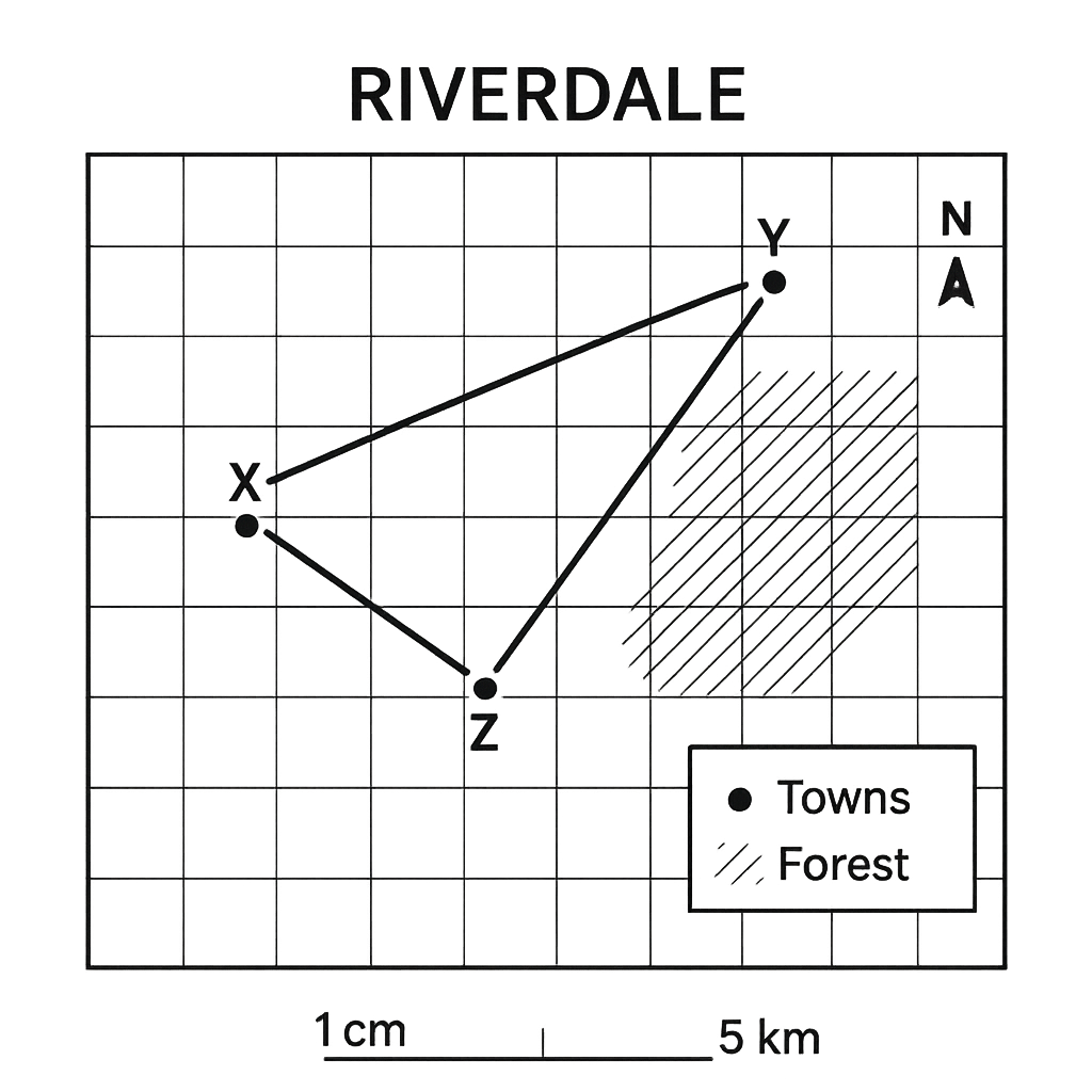
The map of the fictional district of Riverdale is shown. The map scale is 1 cm : 5 km. The map includes the towns of X, Y and Z, a main road connecting them, and a shaded area representing a forest.
Question Parts
(a)
Using the scale, calculate the straight‑line distance between Town X and Town Y. Give your answer in kilometres, rounded to the nearest kilometre.
(b)
Determine the bearing of the road from Town X to Town Z, measured clockwise from true north. Express the bearing as a three‑digit angle.
(c)
The shaded forest occupies six complete grid squares and one half‑square on the map. Each grid square measures 1 cm on a side. Calculate the actual area of the forest in square kilometres.
Detailed Essay Solution & Marking Scheme Available

Get the step-by-step mathematical proofs, key points required by examiners, and a comprehensive breakdown from our AI Tutor.
Question 2 View Details
A map of the coastal region of Lagos Bay is shown. The map scale is 1 cm : 2 km. The map displays Harbour A, Lighthouse B, and a rectangular plot of land.
Question Parts
(a)
The straight‑line distance between Harbour A and Lighthouse B on the map measures 7.5 cm. Find the actual distance between them in kilometres, correct to one decimal place.
Detailed Essay Solution & Marking Scheme Available

Get the step-by-step mathematical proofs, key points required by examiners, and a comprehensive breakdown from our AI Tutor.

Question 3 View Details
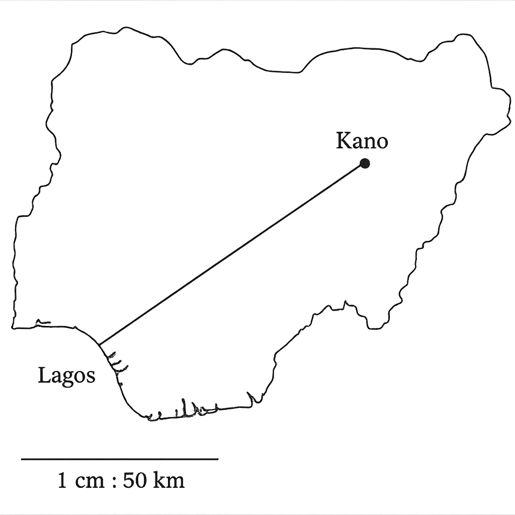
The map of Nigeria shows the locations of Lagos and Kano marked with their latitude and longitude. The map scale is 1 cm : 50 km. The straight‑line distance between the two points on the map, measured with a ruler, is 12 cm.
Question Parts
(a)
Calculate the actual straight‑line distance between Lagos and Kano in kilometres.
(b)
Using the latitude values (Lagos 6.5° N, Kano 12.0° N), determine the north‑south component of the distance in kilometres, assuming 1° latitude ≈ 111 km.
(c)
Comment on the discrepancy between the distances obtained in parts (a) and (b). State at least two reasons why the values differ.
Detailed Essay Solution & Marking Scheme Available

Get the step-by-step mathematical proofs, key points required by examiners, and a comprehensive breakdown from our AI Tutor.

Question 4 View Details
The table below gives the daily weather observations recorded at a coastal town in Nigeria during a week in March. | Day | Temperature (°C) | Humidity (%) | Wind direction | |-----------|------------------|--------------|----------------| | Monday | 28 | 85 | South | | Tuesday | 30 | 78 | North‑East | | Wednesday | 31 | 82 | West | | Thursday | 32 | 70 | East | | Friday | 29 | 55 | North | | Saturday | 27 | 48 | South‑East | | Sunday | 28 | 60 | West | Answer the following questions.
Question Parts
(a)
Identify the day on which the highest temperature was recorded and state that temperature.
Detailed Essay Solution & Marking Scheme Available

Get the step-by-step mathematical proofs, key points required by examiners, and a comprehensive breakdown from our AI Tutor.

Question 5 View Details
The table below shows the mean monthly temperature (°C) and mean monthly rainfall (mm) recorded at the coastal town of Lagos over a typical year. | Month | Temperature (°C) | Rainfall (mm) | |-------|------------------|---------------| | Jan | 27 | 150 | | Feb | 28 | 120 | | Mar | 28 | 180 | | Apr | 29 | 200 | | May | 28 | 250 | | Jun | 27 | 300 | | Jul | 26 | 350 | | Aug | 26 | 340 | | Sep | 27 | 260 | | Oct | 28 | 210 | | Nov | 28 | 180 | | Dec | 27 | 150 |
Question Parts
(a)
Calculate the total annual rainfall and identify the month with the highest rainfall.
(b)
Using the Köppen climate classification, classify the climate of Lagos. Justify your answer with reference to the temperature and rainfall data.
(c)
Discuss two ways in which the climate of Lagos influences agricultural practices in the surrounding region.
Detailed Essay Solution & Marking Scheme Available

Get the step-by-step mathematical proofs, key points required by examiners, and a comprehensive breakdown from our AI Tutor.

Question 6 View Details
A geologist examines a rock sample collected from a river bank in the Niger Delta. The sample is described as follows: it is coarse‑grained, composed mainly of quartz, feldspar and mica, has a visible interlocking texture, and contains occasional small fragments of rounded pebbles. The rock feels gritty when rubbed and does not react with dilute hydrochloric acid.
Question Parts
(a)
Identify the rock type and explain the reasoning behind your identification.
(b)
Outline the geological processes that could have led to the formation of this rock, linking each process to the observed characteristics.
() Transport and rounding of clasts.
() Deposition in a high‑energy environment.
() Lithification (compaction and cementation).
(c)
The geologist intends to use the rock as a building material. Discuss two properties that make it suitable or unsuitable for this purpose, and recommend a treatment or modification to improve its suitability.
Detailed Essay Solution & Marking Scheme Available

Get the step-by-step mathematical proofs, key points required by examiners, and a comprehensive breakdown from our AI Tutor.

Question 7 View Details
The Nigerian landscape exhibits a variety of landforms that result from both endogenic and exogenic processes.
Question Parts
(a)
Define endogenic and exogenic processes and give two examples of each that are relevant to Nigeria.
(b)
The Jos Plateau is a prominent landform in central Nigeria. Explain, with reference to geological history, how the plateau was formed. Include the role of both endogenic and exogenic processes.
(c)
Discuss two ways in which the presence of the Jos Plateau influences human activities (e.g., agriculture, settlement, mineral exploitation) and evaluate the potential environmental challenges associated with these activities.
Detailed Essay Solution & Marking Scheme Available

Get the step-by-step mathematical proofs, key points required by examiners, and a comprehensive breakdown from our AI Tutor.

Question 8 View Details
River systems in Nigeria display diverse drainage characteristics that affect water‑resources management.
Question Parts
(a)
Classify the drainage pattern of the Niger River in its middle course and justify the classification using geomorphological evidence.
(b)
Using the rational method, estimate the peak discharge (in m³/s) for a small catchment in the Benue basin that has the following characteristics: catchment area = 25 km², runoff coefficient = 0.35, design storm intensity = 30 mm/h lasting 2 hours. Show all steps and state any assumptions.
(c)
Evaluate the advantages and disadvantages of constructing a dam on the Benue River for flood control, considering both hydrological and socio‑economic factors.
Detailed Essay Solution & Marking Scheme Available

Get the step-by-step mathematical proofs, key points required by examiners, and a comprehensive breakdown from our AI Tutor.

Question 9 View Details
A soil survey was carried out in a catchment that includes a plateau, a gently sloping hill and a lowland floodplain. Using the information gathered, answer the following.
Question Parts
(a)
Identify the five factors of soil formation that most influence the variation in soil types across the three landforms and explain how each factor affects soil development on the plateau, hill and floodplain.
(b)
The soil profile observed on the plateau is described as O‑A‑E‑Bt‑C‑R. For each horizon, state its principal characteristics and the pedogenic processes that produced it in this environment.
(c)
Recommend two soil‑conservation measures suitable for the plateau and justify how each measure addresses the specific soil problems identified from the profile and the landform.
Detailed Essay Solution & Marking Scheme Available

Get the step-by-step mathematical proofs, key points required by examiners, and a comprehensive breakdown from our AI Tutor.

Question 10 View Details
A botanist is studying the vegetation zones of a tropical savanna region that experiences a distinct wet and dry season. Using the data collected, answer the following.
Question Parts
(a)
Explain how the region’s rainfall pattern and temperature regime determine the distribution of the three major vegetation types – grassland, woodland and shrubland – within the savanna.
(b)
The botanist recorded the following data for three sample plots: Plot 1 (grassland): species richness 12, canopy cover 15 %, average plant height 0.8 m. Plot 2 (woodland): species richness 25, canopy cover 55 %, average plant height 4.5 m. Plot 3 (shrubland): species richness 18, canopy cover 35 %, average plant height 2.2 m. Interpret the data to identify the successional stage of each plot and the dominant disturbance regime likely operating there.
(c)
Propose a management strategy that will maintain or enhance biodiversity across the savanna, linking your recommendations to the successional stages and disturbance regimes identified in part (b).
Detailed Essay Solution & Marking Scheme Available

Get the step-by-step mathematical proofs, key points required by examiners, and a comprehensive breakdown from our AI Tutor.

Master the Exam!

You've seen a preview, but there are thousands more questions plus AI tutor to break down complex solutions.

Unlock Full Access Available for Android & Windows
Help others prepare! Share this practice hub:
Chat with Support