gce model questions vol1 2024 geography | Essay

Prepare for your exams with gce model questions vol1 questions? Reviewing past/model questions is one of the most effective ways to guarantee a high score. This practice hub features authentic 2024 geography (Essay) questions designed to simulate the real exam environment.

Practice these randomly selected questions to test your readiness.
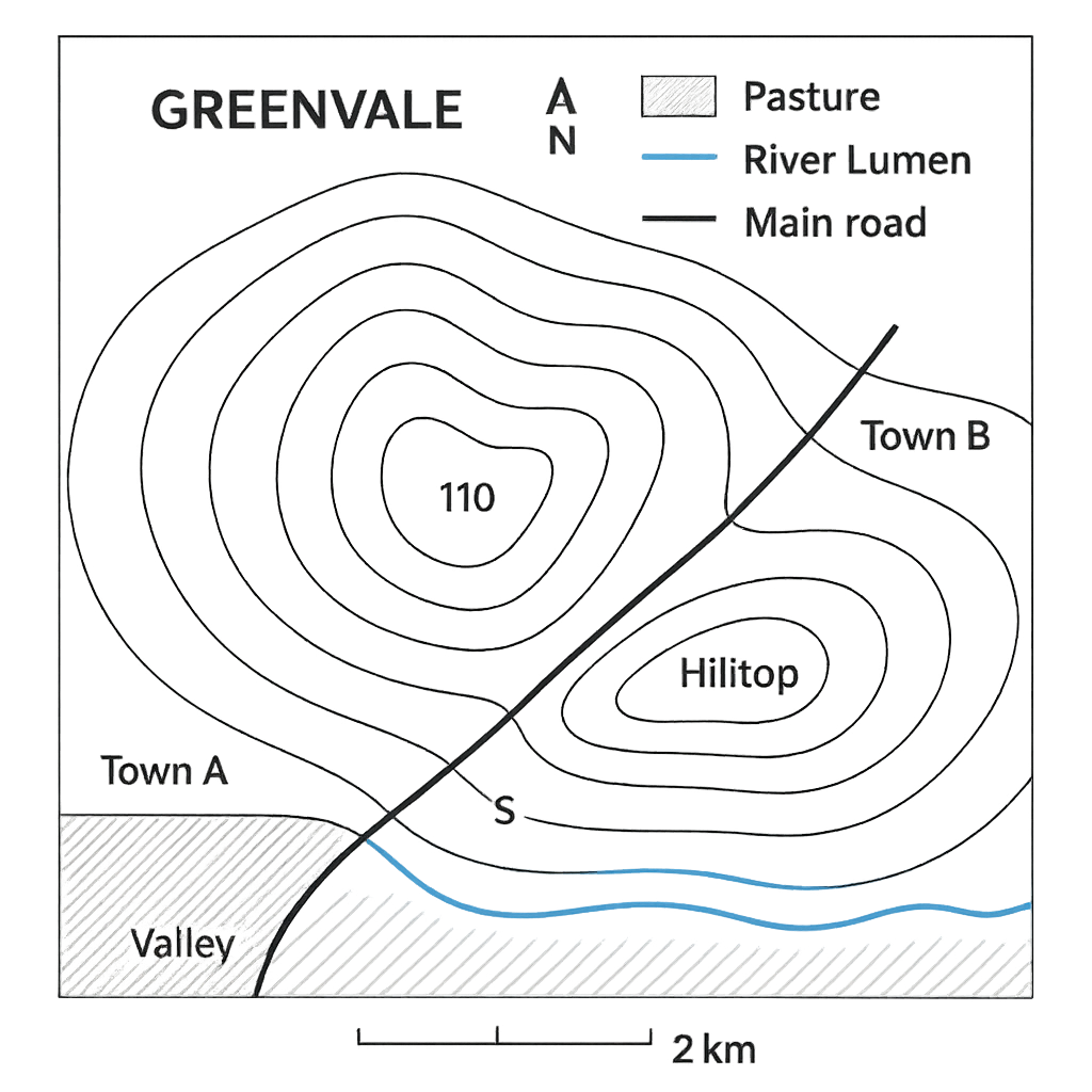
Question 1 View Details
The schematic map below shows the northern part of the fictional county of Greenvale. The map scale is 1 cm = 2 km. A north arrow points upwards. The legend indicates that the crossed‑hatch symbol represents pasture land, the blue line is the River Lumen, and the solid black line is the main road linking the towns. Contour lines are drawn at 10 m intervals and are labelled 120 m, 130 m, 140 m, 150 m, 160 m, 170 m, 180 m. Town A is located at the southern end of the road, Town B at the northern end, and the site marked S lies midway between the two towns, close to the river. Hilltop is the highest point on the map (contour 180 m) and Valley is the lowest point (contour 120 m).
Question Parts
(a)
State the bearing of the road from Town A to Town B as shown on the map.
(b)
Estimate the straight‑line distance between Town A and Town B in kilometres.
(c)
Using the contour lines, calculate the elevation difference between Hilltop and Valley.
(d)
Identify the land‑use type represented by the crossed‑hatch symbol on the map.
(e)
Considering the location of site S, give one advantage and one disadvantage of locating a new secondary school at this site.
Detailed Essay Solution & Marking Scheme Available

Get the step-by-step mathematical proofs, key points required by examiners, and a comprehensive breakdown from our AI Tutor.
Question 2 View Details
The map shown represents Lake Z and its surroundings. The map scale is 1 cm = 0.5 km. The map is drawn on a square grid; each grid square measures 1 cm by 1 cm. Lake Z occupies the shaded area that covers three whole grid squares and two half‑grid squares (as indicated by the shading). The perimeter of the lake, measured with a string on the map, is 8 cm.
Question Parts
(a)
What real‑world distance does a map length of 7.5 cm represent?
(b)
Calculate the actual area of Lake Z in square kilometres.
(c)
Determine the actual perimeter of Lake Z in kilometres.
(d)
Discuss how the chosen scale (1 cm = 0.5 km) influences the level of detail that can be shown on the map. Give two specific examples of features that might be omitted or simplified because of this scale.
Detailed Essay Solution & Marking Scheme Available

Get the step-by-step mathematical proofs, key points required by examiners, and a comprehensive breakdown from our AI Tutor.

Question 3 View Details
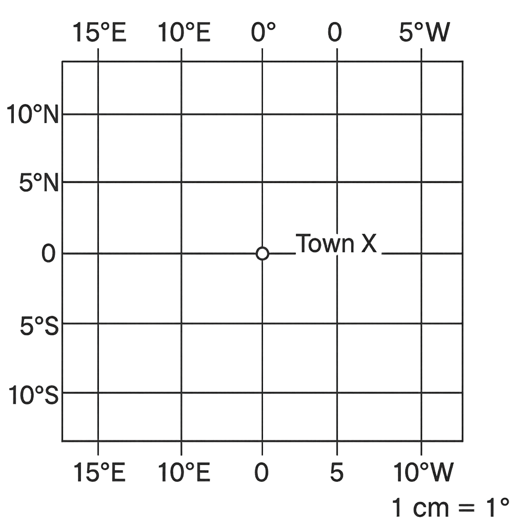
The map shown represents a simplified portion of the Atlantic‑African region with latitude and longitude lines marked. Two coastal towns are indicated: Town X at 5° N, 7° E and Town Y at 2° S, 12° W. The map scale is 1 cm = 1° of latitude or longitude.
Question Parts
(a)
Determine the numerical difference in latitude and in longitude between Town X and Town Y.
(b)
Using the map scale, calculate the north‑south distance and the east‑west distance between the towns in kilometres. (Assume 1° latitude ≈ 111 km and 1° longitude ≈ 111 km × cos average latitude.)
(c)
Treat the north‑south and east‑west distances as the perpendicular sides of a right‑angled triangle and estimate the straight‑line distance between the towns.
(d)
Briefly discuss at least two sources of error that arise from using this planar method instead of a great‑circle calculation.
Detailed Essay Solution & Marking Scheme Available

Get the step-by-step mathematical proofs, key points required by examiners, and a comprehensive breakdown from our AI Tutor.

Question 4 View Details
The climate of the Niger Delta region is characterised by high temperatures, heavy rainfall and high humidity throughout the year.
Question Parts
(a)
Identify the main atmospheric factors that control the amount of rainfall in the Niger Delta.
(b)
Explain the seasonal pattern of rainfall and temperature in the region, linking it to the movement of the Inter‑tropical Convergence Zone (ITCZ).
Detailed Essay Solution & Marking Scheme Available

Get the step-by-step mathematical proofs, key points required by examiners, and a comprehensive breakdown from our AI Tutor.

Question 5 View Details
The table below shows the average monthly temperature (°C) and rainfall (mm) recorded at City X, which lies at 5° N latitude on the coast of a tropical continent. | Month | Temp (°C) | Rainfall (mm) | |-------|----------|---------------| | Jan | 28 | 210 | | Feb | 28 | 190 | | Mar | 27 | 150 | | Apr | 26 | 120 | | May | 25 | 80 | | Jun | 24 | 40 | | Jul | 24 | 30 | | Aug | 25 | 35 | | Sep | 26 | 60 | | Oct | 27 | 110 | | Nov | 27 | 170 | | Dec | 28 | 200 | Using this information, answer the following questions.
Question Parts
(a)
Identify the Köppen climate type of City X and justify your classification with reference to the data provided.
(b)
Explain two major atmospheric processes that give rise to the observed seasonal rainfall pattern in City X.
(c)
A climate model predicts that the mean temperature in City X will rise by 2 °C over the next 30 years. Discuss two likely impacts of this rise on agriculture in the region and propose one practical adaptation strategy for each impact.
Detailed Essay Solution & Marking Scheme Available

Get the step-by-step mathematical proofs, key points required by examiners, and a comprehensive breakdown from our AI Tutor.

Question 6 View Details
A geologist examines a rock outcrop in a river valley and records the following observations: 1. The rock is coarse‑grained, composed mainly of quartz, feldspar and mica. 2. It shows well‑developed foliation that dips 30° to the northeast. 3. The outcrop contains numerous thin, dark bands of volcanic ash interbedded with the coarse material. 4. Radiometric dating of the ash layers yields an age of 150 Ma. Answer the questions that follow.
Question Parts
(a)
Classify the dominant rock type present in the outcrop and explain the basis for your classification.
(b)
Describe the geological processes that could have produced the observed sequence of coarse‑grained metamorphic rock interbedded with thin volcanic ash layers.
(c)
Evaluate the suitability of this rock for use as a building material, considering at least three physical properties, and recommend one treatment that could improve its performance if it were to be used.
Detailed Essay Solution & Marking Scheme Available

Get the step-by-step mathematical proofs, key points required by examiners, and a comprehensive breakdown from our AI Tutor.

Question 7 View Details
The Niger Delta region of Nigeria exhibits a variety of landforms resulting from both tectonic activity and fluvial processes.
Question Parts
(a)
Explain how the processes of river erosion and deposition have contributed to the formation of the Niger Delta's alluvial plain.
(b)
Discuss two major human activities that have altered the natural landforms in the Niger Delta and evaluate their environmental consequences.
(c)
Compare the Niger Delta's landform development with that of the Benue River floodplain, highlighting similarities and differences in the controlling factors.
Detailed Essay Solution & Marking Scheme Available

Get the step-by-step mathematical proofs, key points required by examiners, and a comprehensive breakdown from our AI Tutor.

Question 8 View Details
Consider the River Benue and its tributary system in the central part of Nigeria.
Question Parts
(a)
Identify the drainage pattern exhibited by the River Benue and justify your answer with reference to the river's tributary arrangement.
(b)
Analyse how the underlying geology and climate of the region influence the river's longitudinal profile and discharge variability.
(c)
Propose a sustainable river basin management strategy to mitigate flood risk and water scarcity, incorporating both structural and non‑structural measures.
Detailed Essay Solution & Marking Scheme Available

Get the step-by-step mathematical proofs, key points required by examiners, and a comprehensive breakdown from our AI Tutor.

Question 9 View Details
Discuss the processes of soil formation in the tropical savanna region of Nigeria and evaluate the implications of these processes for agricultural productivity.
Question Parts
(a)
Explain the five factors of soil formation and illustrate how each factor operates in the tropical savanna of Nigeria.
(b)
Using the concept of soil horizons, describe the typical soil profile expected in this region and the reasons for its development.
(c)
Assess the major constraints that the formed soils pose to crop production and suggest two management strategies to mitigate these constraints.
Detailed Essay Solution & Marking Scheme Available

Get the step-by-step mathematical proofs, key points required by examiners, and a comprehensive breakdown from our AI Tutor.

Question 10 View Details
Analyse the pattern of vegetation distribution across the Guinea savanna and forest zones of Nigeria, and discuss how human activities have altered these patterns over the past fifty years.
Question Parts
(a)
Identify the principal physiographic and climatic factors that determine the distribution of Guinea savanna and forest vegetation in Nigeria.
(b)
Compare the typical species composition and structural characteristics of the two zones, highlighting adaptations to their respective environments.
(c)
Critically evaluate the impact of agricultural expansion, logging and urbanisation on these vegetation zones over the last fifty years, and propose two sustainable land‑use practices that could help conserve biodiversity.
Detailed Essay Solution & Marking Scheme Available

Get the step-by-step mathematical proofs, key points required by examiners, and a comprehensive breakdown from our AI Tutor.

Master the Exam!

You've seen a preview, but there are thousands more questions plus AI tutor to break down complex solutions.

Unlock Full Access Available for Android & Windows
Help others prepare! Share this practice hub:
Chat with Support