gce model questions vol1 2022 geography | Objective

Prepare for your exams with gce model questions vol1 questions? Reviewing past/model questions is one of the most effective ways to guarantee a high score. This practice hub features authentic 2022 geography (Objective) questions designed to simulate the real exam environment.

Practice these randomly selected questions to test your readiness.

Question 1 View Details
An igneous rock contains \(30\%\) quartz by volume of its solid mineral component. The remaining solid minerals are feldspar and mica in a volume ratio of \(2:1\). The rock has a porosity of \(5\%\) (voids). What is the overall volume percentage of feldspar in the rock, including the voids? Give your answer to one decimal place.
A. 45.2
B. 42.7
C. 46.0
Correct D. 44.3

Correct Answer: D

Want to see the full step-by-step solution? Unlock AI Explanation & Analytics
Question 2 View Details
At the start of 2020 a town had a population of \(120{,}000\). The annual natural increase rate was \(1.2\%\) in 2020 and rose by \(0.1\%\) each subsequent year. Net migration each year was \(-500\) in 2020, \(-300\) in 2021, \(-200\) in 2022, \(-100\) in 2023 and \(0\) in 2024. Assuming these rates apply for the whole year, what was the population at the start of 2025? Give your answer as the nearest whole number.
A. 127300
B. 127510
C. 127600
Correct D. 127487

Correct Answer: D

Want to see the full step-by-step solution? Unlock AI Explanation & Analytics
Question 3 View Details
The monthly rainfall (mm) for a region is: 80, 70, 60, 50, 40, 30, 20, 30, 40, 50, 60, 70. The mean monthly temperature (°C) is: 25, 26, 27, 28, 29, 30, 31, 30, 29, 28, 27, 26. Approximate monthly potential evapotranspiration (PET) by \(PET = 0.6 \times T\) (mm). Determine the annual water surplus (total rainfall minus total PET) and state the likely dominant natural vegetation: "forest" if the surplus is positive, "savanna" if it is zero (or within \(\pm5\) mm), and "desert" if negative. Provide the vegetation type only.
A. desert
Correct B. forest
C. savanna
D. grassland

Correct Answer: B

Want to see the full step-by-step solution? Unlock AI Explanation & Analytics
Question 4 View Details
In a region three towns have populations: A = \(45{,}000\), B = \(30{,}000\), C = \(20{,}000\). The distances between them are: AB = \(25\) km, AC = \(40\) km, BC = \(30\) km. According to central‑place theory, a settlement can serve as a regional centre if its population exceeds \(35{,}000\) and it is at least \(20\) km away from any other settlement with a population over \(30{,}000\). Which towns qualify as regional centres? Give your answer as the letter(s) of the qualifying town(s).
Correct A. A
B. B
C. C
D. AB

Correct Answer: A

Want to see the full step-by-step solution? Unlock AI Explanation & Analytics
Question 5 View Details
A coastal city faces two hazards. The annual probability of a damaging storm surge is \(0.04\), causing an economic loss of £\(120\) million if it occurs. The annual probability of a magnitude \(7.0\) earthquake is \(0.01\), causing a loss of £\(250\) million. If both events occur in the same year, the combined loss is reduced to £\(300\) million because emergency resources overlap. Assuming the events are independent, calculate the expected annual economic loss for the city (in £ million), rounded to two decimal places.
A. 7.24
B. 7.30
C. 7.55
Correct D. 7.27

Correct Answer: D

Want to see the full step-by-step solution? Unlock AI Explanation & Analytics
Question 6 View Details
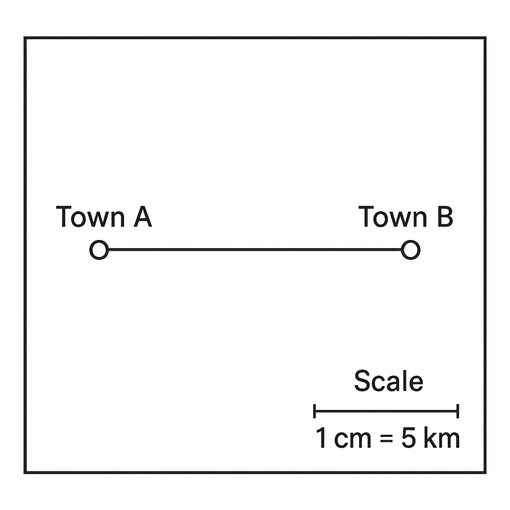
The map has a scale of \(1\text{ cm}=5\text{ km}\). The straight‑line distance between Town A and Town B on the map measures \(7\) cm. What is the actual distance between the two towns in kilometres?
A. 30 km
B. 45 km
C. 40 km
Correct D. 35 km

Correct Answer: D

Want to see the full step-by-step solution? Unlock AI Explanation & Analytics
Question 7 View Details
A shipment must travel \(240\) km. Route A uses a road where the vehicle travels at \(60\) km h\(^{-1}\), incurs a toll of ₦30, and requires \(0.5\) h for loading and \(0.5\) h for unloading. Route B uses a railway where the train travels at \(80\) km h\(^{-1}\), incurs a toll of ₦20, and at the halfway point the cargo must be transferred, adding \(1\) h of handling time. Fuel cost on the road is ₦0.12 per km, while the railway charge is ₦0.08 per km. Which route is both faster and cheaper?
Correct A. Route B (rail) is faster and cheaper
B. Route B (rail) is cheaper but slower
C. Route A (road) is faster but more expensive
D. Route A (road) is faster and cheaper

Correct Answer: A

Want to see the full step-by-step solution? Unlock AI Explanation & Analytics
Question 8 View Details
City X is located at latitude \(5^{\circ}30'\) N, longitude \(7^{\circ}00'\) E. City Y is at latitude \(6^{\circ}15'\) N, longitude \(8^{\circ}45'\) E. Assuming 1° of latitude equals 111 km and the length of 1° of longitude equals \(111\cos\phi\) km where \(\phi\) is the latitude, estimate the straight‑line distance between the two cities in kilometres (round to the nearest kilometre).
A. 190 km
B. 230 km
C. 250 km
Correct D. 210 km

Correct Answer: D

Want to see the full step-by-step solution? Unlock AI Explanation & Analytics
Question 9 View Details
Two open channels convey water down the same slope. Channel 1 is rectangular, 3 m wide and 1.2 m deep, with a slope of 0.001 and Manning's \(n = 0.030\). Channel 2 is trapezoidal with a bottom width of 2 m, side slopes of 1:1, a depth of 1.5 m, a slope of 0.0015 and Manning's \(n = 0.025\). Using Manning's equation, which channel has the greater discharge and by what factor (to one decimal place)?
A. Channel 2, about 1.8 times the discharge of Channel 1
B. Channel 1, about 2.5 times the discharge of Channel 2
Correct C. Channel 2, about 2.5 times the discharge of Channel 1
D. Channel 2, about 3.0 times the discharge of Channel 1

Correct Answer: C

Want to see the full step-by-step solution? Unlock AI Explanation & Analytics
Question 10 View Details
On a map the scale is \(1\text{ cm}=2\text{ km}\). The measured distance between points C and D on the map is \(4.2\) cm. What is the actual distance between C and D in kilometres?
A. 10.5 km
Correct B. 8.4 km
C. 2.1 km
D. 4.2 km

Correct Answer: B

Want to see the full step-by-step solution? Unlock AI Explanation & Analytics
Question 11 View Details
A company plans to produce 10,000 units of a product per year. It can locate its factory at either Site A or Site B. - Site A: labour cost £8 per hour, 2 labour hours required per unit, distance to market 150 km, fixed annual overhead £500,000. - Site B: labour cost £6 per hour, 2.5 labour hours required per unit, distance to market \(D\) km (to be determined), fixed annual overhead £300,000. Transport cost is £0.5 per kilometre per unit. Determine the distance \(D\) (in km) at which the total annual cost of operating at Site B equals that of Site A.
Correct A. 192 km
B. 165 km
C. 180 km
D. 210 km

Correct Answer: A

Want to see the full step-by-step solution? Unlock AI Explanation & Analytics
Question 12 View Details
The daily temperature (in °C) in a town can be modelled by \(T(t) = 20 + 8\sin\left(\frac{\pi t}{12}\right)\), where \(t\) is the number of hours after midnight (0 \(\le t \le 24\)). Determine the time(s) when the temperature is rising at exactly \(2^{\circ}\)C per hour.
Correct A. approximately 01:10 and 22:50
B. approximately 05:55 and 18:05
C. approximately 03:20 and 20:40
D. approximately 04:45 and 19:15

Correct Answer: A

Want to see the full step-by-step solution? Unlock AI Explanation & Analytics
Question 13 View Details
A vegetation survey of a 1 ha plot records the following numbers of individuals for four plant species: Species A - 40, Species B - 25, Species C - 20, Species D - 15. Using Simpson's Index of Diversity \(1-D\), where \(D = \frac{\sum n_i (n_i-1)}{N(N-1)}\), calculate the index to two decimal places.
A. 0.75
B. 0.68
Correct C. 0.72
D. 0.81

Correct Answer: C

Want to see the full step-by-step solution? Unlock AI Explanation & Analytics
Question 14 View Details
The city of Lagos is located at approximately 6° 27′ N latitude and 3° 24′ E longitude. Express its latitude in decimal degrees, rounded to two decimal places.
A. 6.52° N
B. 6.60° N
C. 6.38° N
Correct D. 6.45° N

Correct Answer: D

Want to see the full step-by-step solution? Unlock AI Explanation & Analytics
Question 15 View Details
A region is exposed to two environmental hazards. - Flood: annual probability 0.02, potential damage cost £5 million. - Landslide: annual probability 0.005, potential damage cost £12 million. A mitigation programme costs £1 million per year. It reduces the flood probability by 40 % and the landslide probability by 20 %. (a) Which hazard contributes more to the expected annual loss before mitigation? (b) After implementing the mitigation programme, what is the net change in expected annual loss (including the mitigation cost)? State whether the programme reduces the total expected loss.
A. Landslide contributes more; mitigation decreases expected annual loss by £1,200,000, so it reduces the total loss.
Correct B. Flood contributes more; mitigation increases expected annual loss by £948,000, so it does not reduce the total loss.
C. Flood contributes more; mitigation increases expected annual loss by £1,050,000, so it does not reduce the total loss.
D. Flood contributes more; mitigation decreases expected annual loss by £500,000, so it reduces the total loss.

Correct Answer: B

Want to see the full step-by-step solution? Unlock AI Explanation & Analytics
Question 16 View Details
The following monthly climate data are recorded for a location: Month | Avg Temp (°C) | Precip (mm) --- | --- | --- Jan | 22 | 20 Feb | 23 | 30 Mar | 25 | 40 Apr | 27 | 80 May | 28 | 120 Jun | 30 | 150 Jul | 31 | 180 Aug | 31 | 170 Sep | 29 | 130 Oct | 27 | 80 Nov | 24 | 40 Dec | 22 | 30 Seventy percent of the annual precipitation falls in the summer months (April-September). Using the Köppen classification, determine the climate type of the location (e.g., Af, Am, Aw, Cfa, etc.).
Correct A. Aw
B. Cfa
C. Am
D. Af

Correct Answer: A

Want to see the full step-by-step solution? Unlock AI Explanation & Analytics
Question 17 View Details
Two settlements are being considered for a new district hospital. Settlement A: area = 45 km\(^2\), population = 120,000, farthest point from the existing clinic = 6 km. Settlement B: area = 50 km\(^2\), population = 150,000, farthest point from the existing clinic = 4 km. The hospital planning guidelines require a minimum population density of 2,500 persons per km\(^2\) and that no resident be more than 5 km from the nearest health facility. Which settlement satisfies both criteria?
A. Both settlements
B. Settlement A
Correct C. Settlement B
D. Neither settlement

Correct Answer: C

Want to see the full step-by-step solution? Unlock AI Explanation & Analytics
Question 18 View Details
A soil profile consists of three horizons to a depth of 1.0 m: - Horizon A (0-30 cm): field capacity \(\theta_{FC}=0.30\), wilting point \(\theta_{WP}=0.15\). - Horizon B (30-70 cm): \(\theta_{FC}=0.28\), \(\theta_{WP}=0.13\). - Horizon C (70-100 cm): \(\theta_{FC}=0.25\), \(\theta_{WP}=0.12\). Assume a uniform bulk density of 1.3 g cm\(^-3\) for all horizons. The available water in each horizon is calculated as \((\theta_{FC}-\theta_{WP})\times\text{depth (cm)}\times10\) to give millimetres of water. A wheat crop requires at least 150 mm of available water in the root zone (0-1.0 m). Is this soil suitable for wheat cultivation?
Correct A. No
B. Insufficient
C. Yes
D. Possibly

Correct Answer: A

Want to see the full step-by-step solution? Unlock AI Explanation & Analytics
Question 19 View Details
A region has the following climatic and soil characteristics: - Mean annual temperature = 15\(^{\circ}\)C - Annual precipitation = 800 mm, with 70% falling in the winter months. - Soil pH = 5.5 (acidic). Based on these data, which natural vegetation type is most likely to dominate the landscape? Choose from: Temperate deciduous forest, Mediterranean shrubland, Boreal forest, Temperate grassland.
A. Temperate deciduous forest
Correct B. Mediterranean shrubland
C. Boreal forest
D. Temperate grassland

Correct Answer: B

Want to see the full step-by-step solution? Unlock AI Explanation & Analytics
Question 20 View Details
Using the Universal Soil Loss Equation (USLE), estimate the average annual soil loss for a field with the following parameters: - Rainfall erosivity factor \(R = 300\) (MJ·mm ha⁻¹ h⁻¹ yr⁻¹) - Soil erodibility factor \(K = 0.03\) (t·ha·h·ha⁻¹·MJ⁻¹·mm⁻¹) - Slope length \(\lambda = 150\) m - Slope gradient = 12%\n- Cover‑management factor \(C = 0.2\) - Support practice factor \(P = 0.5\) The slope length‑steepness factor \(LS\) is to be calculated with the empirical formula \(LS = \left(\frac{\lambda}{22.13}\right)^{0.5} \times \left(\frac{\sin \theta}{0.0896}\right)^{1.3}\), where \(\theta\) is the slope angle (\(\theta = \arctan(\text{slope%}/100)\)). Calculate \(LS\), then the predicted soil loss \(A = R \times K \times LS \times C \times P\) (t·ha⁻¹·yr⁻¹). Is the predicted loss above the critical threshold of 5 t·ha⁻¹·yr⁻¹?
A. 4.1
B. 5
C. 2.9
Correct D. 3.4

Correct Answer: D

Want to see the full step-by-step solution? Unlock AI Explanation & Analytics
Question 21 View Details
A town had a population of 120,000 in the year 2000. From 2000 to 2005 the population grew at an annual rate of \(2.5\%\). From 2005 onward the annual growth rate decreased by \(0.5\%\) each year (i.e., \(2.5\%\) in 2005‑06, \(2.0\%\) in 2006‑07, etc.). In which year does the population first exceed \(140,000\)?
A. 2009
B. 2008
Correct C. 2007
D. 2006

Correct Answer: C

Want to see the full step-by-step solution? Unlock AI Explanation & Analytics
Question 22 View Details
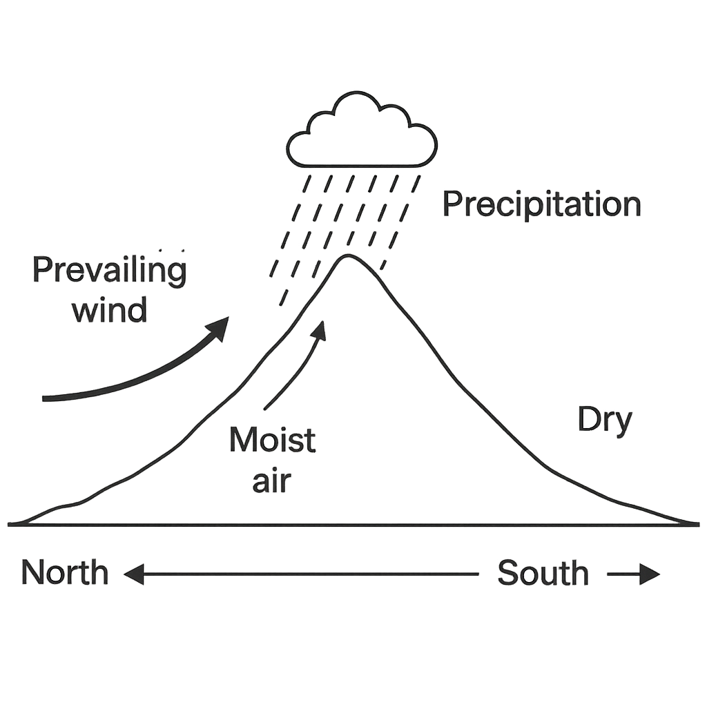
The diagram shows a north‑south mountain range. A prevailing wind blows from the west, indicated by an arrow. Moist air rises up the western slope, forming clouds and precipitation, while the eastern side lies in the rain‑shadow and is shown as a dry valley. Based on this diagram, which side of the mountain range receives the greatest annual rainfall and why?
A. The eastern (leeward) side, because the prevailing wind deposits moisture there after crossing the summit.
B. The northern side, because it is higher in elevation and forces more air to rise.
Correct C. The western (windward) side, because moist air rises over it, cools and releases precipitation, while the eastern side lies in the rain‑shadow.
D. Both sides receive similar rainfall, as the wind brings moisture uniformly across the range.

Correct Answer: C

Want to see the full step-by-step solution? Unlock AI Explanation & Analytics
Question 23 View Details
Region A has the following mean monthly temperatures (°C): Jan 22, Feb 23, Mar 25, Apr 27, May 30, Jun 33, Jul 35, Aug 34, Sep 31, Oct 28, Nov 25, Dec 23. Its mean monthly precipitation (mm) is: Jan 80, Feb 70, Mar 60, Apr 50, May 40, Jun 30, Jul 20, Aug 20, Sep 30, Oct 50, Nov 70, Dec 80.\ Region B has mean monthly temperatures (°C): Jan 5, Feb 7, Mar 12, Apr 18, May 22, Jun 27, Jul 30, Aug 29, Sep 24, Oct 18, Nov 11, Dec 6. Its mean monthly precipitation (mm) is: Jan 120, Feb 110, Mar 100, Apr 80, May 60, Jun 40, Jul 30, Aug 30, Sep 50, Oct 80, Nov 110, Dec 120.\ (a) Determine the Köppen climate classification for each region.\ (b) A crop requires at least 600 mm of annual rainfall and an average temperature of at least 20 °C during the growing months (April-September). Which region is more suitable for cultivating this crop? Justify your answer.
Correct A. Region A; it meets both the 600 mm rainfall requirement and has average temperatures ≥ 20 °C from April to September, whereas Region B fails the temperature criterion in April.
B. Region A; it meets the rainfall requirement but its average temperature falls below 20 °C in July, making it unsuitable.
C. Region B; it meets both the 600 mm rainfall requirement and has average temperatures ≥ 20 °C from April to September, whereas Region A fails the temperature criterion in May.
D. Both regions are equally suitable; each provides at least 600 mm rainfall and average temperatures above 20 °C during the growing months.

Correct Answer: A

Want to see the full step-by-step solution? Unlock AI Explanation & Analytics
Question 24 View Details
Three environmental hazards have the following estimated annual probabilities and potential economic losses:\\ - Flood: probability \(2\%\) per year, loss \(500\) million Naira.\ - Landslide: probability \(0.5\%\) per year, loss \(800\) million Naira.\ - Industrial accident: probability \(1\%\) per year, loss \(300\) million Naira.\\ Mitigation options are:\ - Flood barrier costing \(50\) million Naira, reducing flood probability by \(60\%\).\ - Slope stabilization costing \(80\) million Naira, reducing landslide probability by \(70\%\).\ - Safety training costing \(20\) million Naira, reducing industrial accident probability by \(50\%\).\ (a) Calculate the risk score (probability × loss) for each hazard.\ (b) For each mitigation, compute the new risk score after implementation and the risk reduction per million Naira spent.\ (c) Which mitigation provides the greatest risk reduction per unit cost?
A. The landslide stabilization; it reduces risk by 5.6 million Naira at a cost of 80 million Naira, giving the highest reduction per unit cost (0.07 million risk reduced per million Naira).
Correct B. The flood barrier; it reduces risk by 6 million Naira at a cost of 50 million Naira, giving the highest reduction per unit cost (0.12 million risk reduced per million Naira).
C. The safety training; it reduces risk by 1.5 million Naira at a cost of 20 million Naira, resulting in a reduction of 0.075 million risk per million Naira, which is the greatest.
D. The flood barrier; it reduces risk by 6 million Naira at a cost of 50 million Naira, but the safety training provides a higher reduction per unit cost.

Correct Answer: B

Want to see the full step-by-step solution? Unlock AI Explanation & Analytics
Question 25 View Details
A map has a scale of 1 cm : 5 km. The distance between Town X and Town Y measured on the map is 7.4 cm. What is the actual distance between the two towns in kilometres?
A. 370 km
B. 42 km
C. 3.7 km
Correct D. 37 km

Correct Answer: D

Want to see the full step-by-step solution? Unlock AI Explanation & Analytics

Master the Exam!

You've seen a preview, but there are thousands more questions plus AI tutor to break down complex solutions.

Unlock Full Access Available for Android & Windows
Help others prepare! Share this practice hub:
Chat with Support