gce model questions vol1 2022 geography | Essay

Prepare for your exams with gce model questions vol1 questions? Reviewing past/model questions is one of the most effective ways to guarantee a high score. This practice hub features authentic 2022 geography (Essay) questions designed to simulate the real exam environment.

Practice these randomly selected questions to test your readiness.
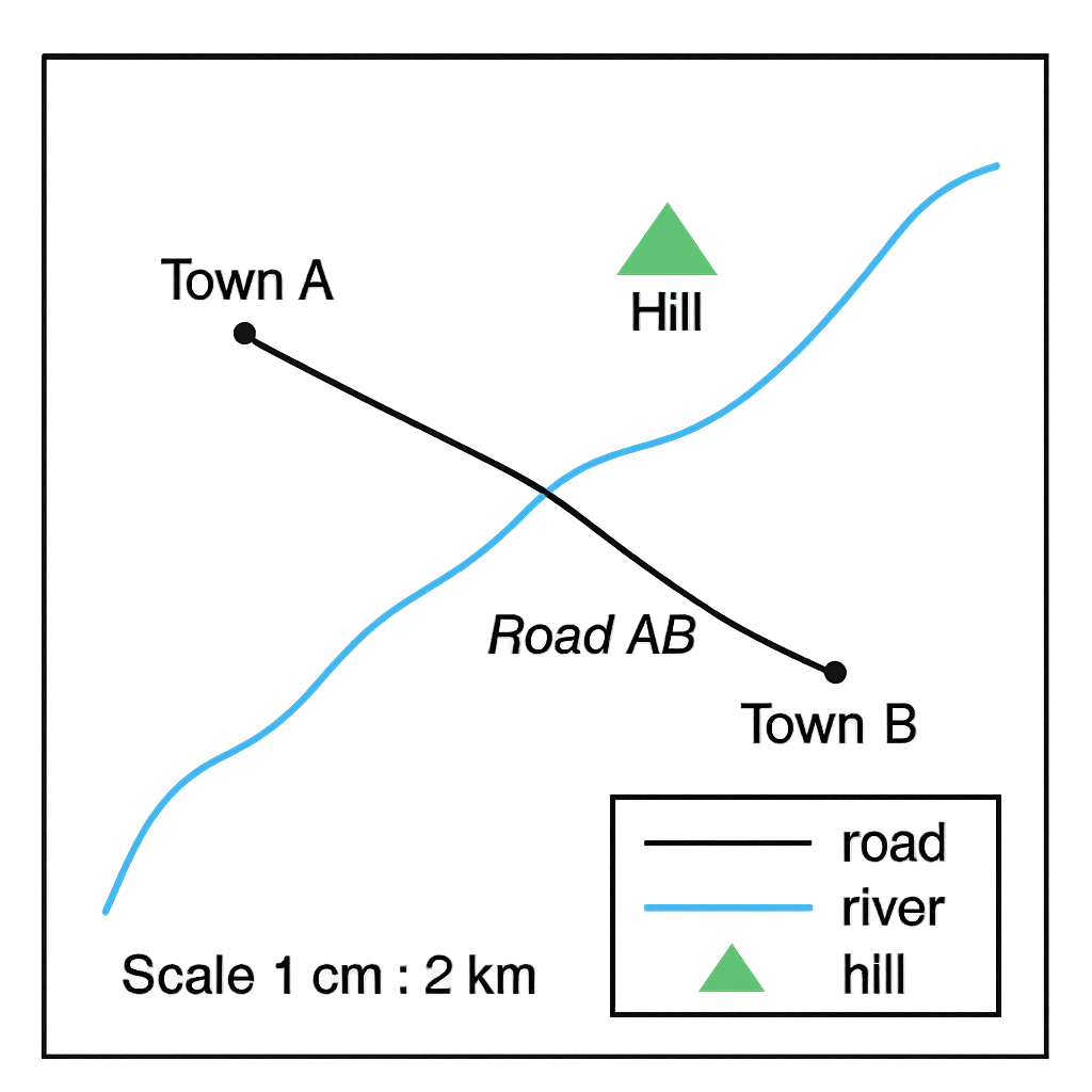
Question 1 View Details
The map shown represents a portion of the Riverine State. The map scale is 1 cm : 2 km. The map legend indicates that a solid black line represents a road, a blue line represents a river and a green triangle denotes a hill. Town A is marked at the point (2 cm, 6 cm) measured from the bottom‑left corner of the map and Town B is marked at (7 cm, 2 cm). The road connecting the two towns is drawn as a straight black line. Using the information on the map answer the following.
Question Parts
(a)
State the true bearing from Town A to Town B (give your answer to the nearest degree).
(b)
Calculate the straight‑line distance between the two towns in kilometres (give your answer to one decimal place).
(c)
Identify the symbol that represents the river on the map and explain how you recognised it.
Detailed Essay Solution & Marking Scheme Available

Get the step-by-step mathematical proofs, key points required by examiners, and a comprehensive breakdown from our AI Tutor.
Question 2 View Details
The map below shows a hilly region of the Central Plateau. The map scale is 1 cm : 1 km. Contour lines are drawn at 20 m intervals. A rectangular grid of 1 km × 1 km squares is superimposed on the map for area estimation. The following information is given: - Point P (on a contour line) is at elevation 120 m and is located 3 cm east of the left‑hand edge of the map. - Point Q (on the next higher contour) is at elevation 200 m and lies 8 cm east of the left‑hand edge on the same horizontal line as P. - The forested area (shaded on the map) covers 12 whole grid squares and half of 4 additional squares. - The road from Town X to Town Y follows a winding route whose length on the map measures 15 cm. - A vehicle travels this road at an average speed of 45 km h⁻¹. Using the map, answer the following questions.
Question Parts
(a)
Determine the gradient between points P and Q expressed as a percentage (give your answer to one decimal place).
(b)
Estimate the area of the forested region in square kilometres.
(c)
Calculate the travel time required for the vehicle to go from Town X to Town Y along the road. Express your answer in minutes (rounded to the nearest whole minute).
Detailed Essay Solution & Marking Scheme Available

Get the step-by-step mathematical proofs, key points required by examiners, and a comprehensive breakdown from our AI Tutor.

Question 3 View Details
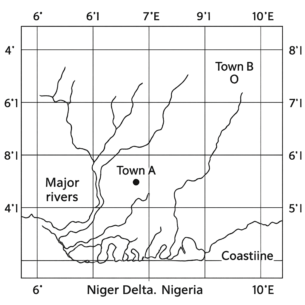
The map shows the positions of Town A and Town B in the Niger Delta region. Latitude and longitude lines are marked at 1° intervals. Town A is located at 5°30' N, 7°15' E and Town B at 7°10' N, 9°45' E.
Question Parts
(a)
Using the coordinates given, determine the approximate straight‑line distance between the two towns in kilometres. Show all steps and state any assumptions you make.
(b)
State the initial bearing (direction) from Town A to Town B, rounded to the nearest whole degree, and explain how you obtained it.
(c)
Discuss two geographical factors that could cause the actual travel distance by road between the towns to differ significantly from the straight‑line distance you calculated in part (a).
Detailed Essay Solution & Marking Scheme Available

Get the step-by-step mathematical proofs, key points required by examiners, and a comprehensive breakdown from our AI Tutor.

Question 4 View Details
City Z is a coastal city in southern Nigeria. The table below summarises its average monthly climate data (derived from a 30‑year period).
Question Parts
(a)
Identify the Köppen climate type of City Z, giving a concise justification based on the data.
(b)
Explain the atmospheric processes that lead to the peak rainfall occurring in July.
(c)
Evaluate two possible impacts of this climate on agricultural practices in the region and suggest one adaptation strategy for each impact.
Detailed Essay Solution & Marking Scheme Available

Get the step-by-step mathematical proofs, key points required by examiners, and a comprehensive breakdown from our AI Tutor.

Question 5 View Details
The table below shows the average monthly maximum temperature (°C) and total rainfall (mm) recorded at a coastal city in Nigeria over a typical year. | Month | Max Temp (°C) | Rainfall (mm) | |-------|---------------|---------------| | Jan | 27 | 30 | | Feb | 28 | 40 | | Mar | 28 | 60 | | Apr | 28 | 80 | | May | 27 | 120 | | Jun | 26 | 200 | | Jul | 26 | 250 | | Aug | 26 | 240 | | Sep | 27 | 180 | | Oct | 27 | 100 | | Nov | 27 | 50 | | Dec | 27 | 30 | Using this information, answer the following: (a) Calculate the mean annual temperature and the total annual rainfall. (b) Classify the climate of the city according to the Köppen system and justify your choice with reference to the data. (c) Discuss two major physical factors that influence the climate of the city and two human activities that modify it. (d) Recommend two practical adaptation measures that local farmers could adopt to cope with the observed climate variability.
Question Parts
(a)
Calculate the mean annual temperature and the total annual rainfall.
(b)
Classify the climate of the city according to the Köppen system and justify your choice with reference to the data.
(c)
Discuss two major physical factors that influence the climate of the city and two human activities that modify it.
(d)
Recommend two practical adaptation measures that local farmers could adopt to cope with the observed climate variability.
Detailed Essay Solution & Marking Scheme Available

Get the step-by-step mathematical proofs, key points required by examiners, and a comprehensive breakdown from our AI Tutor.

Question 6 View Details
In Region X three distinct rock units are exposed as follows: - Unit A: A coarse‑grained pink granite that cuts across the other units and contains visible feldspar crystals. - Unit B: A red sandstone with well‑preserved cross‑bedding and fossil shells; it lies beneath Unit C. - Unit C: A dark basaltic lava flow that overlies Unit B and displays columnar jointing. The field observations record that the granite (Unit A) intrudes both the sandstone (Unit B) and the basalt (Unit C). No other structural relationships are noted. Answer the following: (a) Identify the three rock types and briefly describe the geological processes that formed each. (b) Using the principles of superposition, original horizontality and cross‑cutting relationships, determine the relative chronological order of formation of the three units. (c) Discuss two major economic uses of these rocks and two environmental concerns associated with their extraction in the region.
Question Parts
(a)
Identify the three rock types and briefly describe the geological processes that formed each.
Detailed Essay Solution & Marking Scheme Available

Get the step-by-step mathematical proofs, key points required by examiners, and a comprehensive breakdown from our AI Tutor.

Question 7 View Details
You are a geographer preparing a coastal management report for the Niger Delta region. The report focuses on a barrier beach that has developed along a low‑energy shoreline.
Question Parts
(a)
Explain the sequence of geomorphological processes that lead to the formation of a barrier beach on a low‑energy coast.
(b)
Compare the barrier beach with the adjacent inland dune system in terms of (i) sediment supply, (ii) wave energy exposure, and (iii) role of vegetation in stabilisation.
(c)
Identify two major human activities that threaten the stability of the barrier beach and propose one practical management measure for each activity.
Detailed Essay Solution & Marking Scheme Available

Get the step-by-step mathematical proofs, key points required by examiners, and a comprehensive breakdown from our AI Tutor.

Question 8 View Details
A river basin in northern Nigeria has the following characteristics: - Catchment area: 2 500 km² - Mean annual rainfall: 1 200 mm - Average annual evapotranspiration: 600 mm - Mean annual discharge at the basin outlet: 50 m³ s⁻¹ - Main river gradient: 0.0015 (gentle) - River pattern: meandering You are required to analyse the hydrology of the basin and assess its suitability for a small hydro‑electric scheme.
Question Parts
(a)
Calculate the runoff coefficient for the basin. Show all steps and state any assumptions you make.
(b)
Explain how the basin’s gentle gradient and meandering river pattern influence the flood risk in the downstream area.
(c)
The basin is being considered for a small hydro‑electric project. Evaluate two advantages and two disadvantages of developing such a scheme, using the hydrological data provided.
Detailed Essay Solution & Marking Scheme Available

Get the step-by-step mathematical proofs, key points required by examiners, and a comprehensive breakdown from our AI Tutor.

Question 9 View Details
You are required to discuss various aspects of soils in Nigeria, focusing on their formation, properties and management.
Question Parts
(a)
Explain the main processes of soil formation (pedogenesis) that operate in the tropical savanna region of northern Nigeria. In your answer, identify the climatic, biological and parent material factors that influence each process.
(b)
Discuss how the physical and chemical properties of these soils affect their suitability for yam (Dioscorea spp.) cultivation.
(c)
Evaluate two soil‑conservation measures that could be introduced in this region to sustain yam production, taking into account socio‑economic constraints of small‑holder farmers.
Detailed Essay Solution & Marking Scheme Available

Get the step-by-step mathematical proofs, key points required by examiners, and a comprehensive breakdown from our AI Tutor.

Question 10 View Details
Answer the following questions on the vegetation of Nigeria, using your knowledge of climate, soils and human impact.
Question Parts
(a)
Describe the major vegetation zones of Nigeria, stating the key climatic and edaphic factors that characterise each zone.
(b)
A low‑lying area on the Niger Delta, historically dominated by mangrove forest, has undergone marked change over the past 50 years. (i) Identify three major changes in the species composition of this area. (ii) Explain two principal human‑driven forces that have caused these changes.
() Identify three major changes in the species composition of this area.
() Explain two principal human‑driven forces that have caused these changes.
(c)
Propose a management plan to restore biodiversity in a degraded mangrove area of the Niger Delta. Your plan should contain at least three specific actions and a brief justification for each.
Detailed Essay Solution & Marking Scheme Available

Get the step-by-step mathematical proofs, key points required by examiners, and a comprehensive breakdown from our AI Tutor.

Master the Exam!

You've seen a preview, but there are thousands more questions plus AI tutor to break down complex solutions.

Unlock Full Access Available for Android & Windows
Help others prepare! Share this practice hub:
Chat with Support