gce model questions vol1 2021 geography | Essay

Prepare for your exams with gce model questions vol1 questions? Reviewing past/model questions is one of the most effective ways to guarantee a high score. This practice hub features authentic 2021 geography (Essay) questions designed to simulate the real exam environment.

Practice these randomly selected questions to test your readiness.
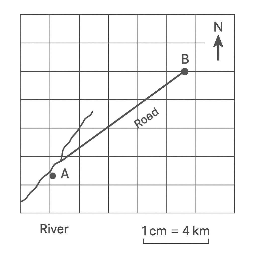
Question 1 View Details
The map shown represents a small region. The scale is 1 cm : 4 km. North is indicated by the upward‑pointing arrow. Three towns are marked as follows: Town A is located at (2 cm, 3 cm), Town B at (8 cm, 7 cm) and Town C at (5 cm, 1 cm) measured from the south‑west corner of the map. A river runs diagonally from the lower‑left corner to the upper‑right corner and a road links Town A directly to Town B.
Question Parts
(a)
Calculate the straight‑line distance between Town A and Town B on the ground, giving your answer in kilometres to one decimal place.
(b)
Determine the bearing of Town B from Town A, expressed as a three‑figure bearing (e.g., 056°).
(c)
Using the scale, calculate the area of the triangle formed by the three towns (A, B and C) on the ground. Give your answer in square kilometres to the nearest whole number.
Detailed Essay Solution & Marking Scheme Available

Get the step-by-step mathematical proofs, key points required by examiners, and a comprehensive breakdown from our AI Tutor.
Question 2 View Details
The map below shows a proposed road network linking four villages – D, E, F and G – in a rural district. The map scale is 1 cm : 0.5 km (i.e., 1 cm represents 0.5 km). The road segments are measured on the map as follows: DE = 3 cm, EF = 4.5 cm, FG = 2 cm and GD = 5 cm, forming a closed loop.
Question Parts
(a)
Calculate the total length of the road network on the ground in kilometres, giving your answer to two decimal places.
(b)
If a vehicle travels the entire loop at a constant speed of 60 km h⁻¹, estimate the travel time in minutes, rounded to one decimal place.
(c)
Discuss how a 5 % error in the map scale would affect the estimated total distance and travel time. Consider both an over‑estimation and an under‑estimation of the scale.
Detailed Essay Solution & Marking Scheme Available

Get the step-by-step mathematical proofs, key points required by examiners, and a comprehensive breakdown from our AI Tutor.

Question 3 View Details
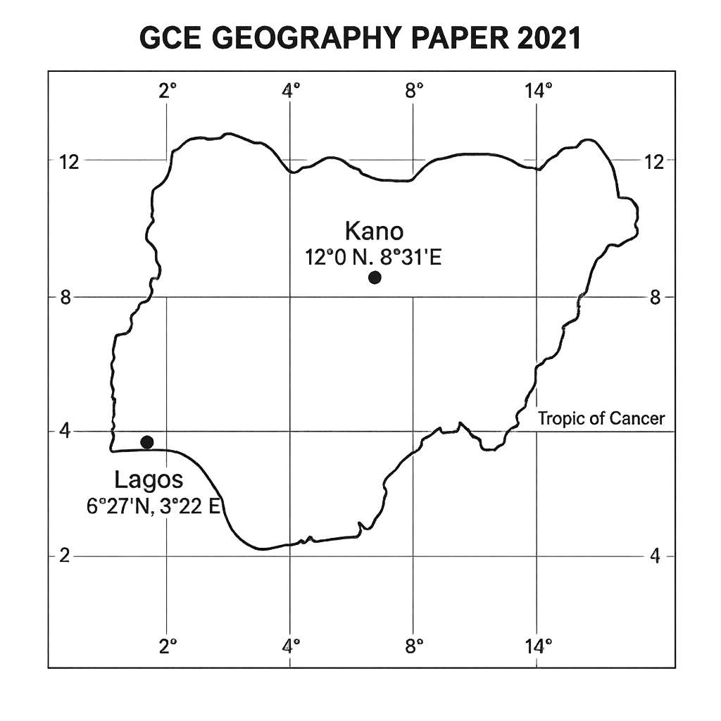
The map shows the positions of Lagos and Kano in Nigeria with their latitude and longitude coordinates.
Question Parts
(a)
Using the coordinates given on the map, calculate the approximate great‑circle distance between Lagos and Kano. Show all steps, including conversion of degrees to radians and the use of the haversine formula. (Assume the Earth’s radius is 6 371 km.)
(b)
The map indicates that the Tropic of Cancer passes through the northern part of the country. Explain how the position of the Tropic of Cancer influences the climate differences between Lagos and Kano.
(c)
If a new railway is to be built in a straight line between the two cities, discuss two geographical factors (other than distance) that engineers must consider when planning the route.
Detailed Essay Solution & Marking Scheme Available

Get the step-by-step mathematical proofs, key points required by examiners, and a comprehensive breakdown from our AI Tutor.

Question 4 View Details
The table below gives the average monthly temperature (°C) and average monthly rainfall (mm) for three Nigerian cities – Lagos, Abuja and Kano – based on a 30‑year climatological record.
Question Parts
(a)
Identify which of the three cities exhibits the most pronounced seasonal rainfall pattern and justify your choice using the data.
(b)
Explain how the seasonal movement of the Intertropical Convergence Zone (ITCZ) influences the rainfall distribution among Lagos, Abuja and Kano.
Detailed Essay Solution & Marking Scheme Available

Get the step-by-step mathematical proofs, key points required by examiners, and a comprehensive breakdown from our AI Tutor.

Question 5 View Details
Nigeria experiences a range of climatic zones from equatorial to arid. Recent climatological records indicate that the national mean annual temperature has risen by about 1.5 °C over the past three decades and that July rainfall in the Sahelian region is projected to fall by roughly 10 % in the next twenty years.
Question Parts
(a)
Explain how an increase of 1.5 °C in average annual temperature could affect the phenology of staple crops such as maize in the Sudanian zone.
(b)
Discuss two major socio‑economic consequences that could arise from a projected 10 % decline in average July rainfall in the Sahelian region.
(c)
Propose two adaptation strategies that the Nigerian government could implement to mitigate the impacts identified in parts (a) and (b). Justify how each strategy addresses the underlying climate challenge.
Detailed Essay Solution & Marking Scheme Available

Get the step-by-step mathematical proofs, key points required by examiners, and a comprehensive breakdown from our AI Tutor.

Question 6 View Details
The geology of Nigeria comprises an extensive Precambrian basement complex, Cretaceous sedimentary basins and more recent volcanic formations such as the Jos Plateau. Understanding rock types and their formation is essential for land‑use planning.
Question Parts
(a)
Distinguish between igneous, sedimentary and metamorphic rocks in terms of (i) their formation process, (ii) typical mineral composition, and (iii) common land‑use implications in Nigeria.
(b)
A rock sample from the Jos Plateau is described as coarse‑grained, pink, and contains visible feldspar and quartz crystals. Identify the rock type and explain the geological conditions that led to its formation.
(c)
Evaluate how the presence of laterite soils derived from weathering of basaltic rocks influences agricultural productivity in the surrounding lowland areas. Include both benefits and constraints.
Detailed Essay Solution & Marking Scheme Available

Get the step-by-step mathematical proofs, key points required by examiners, and a comprehensive breakdown from our AI Tutor.

Question 7 View Details
The coastal region of southern Nigeria transitions inland to a lowland plain, a dissected plateau and finally an eroded inselberg. The area experiences a tropical monsoon climate with a mean annual rainfall of 2100 mm and a mean temperature of 27°C.
Question Parts
(a)
Identify the four landforms mentioned and describe the dominant geological processes that have produced each of them.
(b)
Explain how the prevailing climate influences the rates of weathering and soil development on the plateau and the inselberg.
(c)
Evaluate the suitability of each landform for sustainable human activities such as agriculture, settlement and tourism, giving reasons for any constraints.
Detailed Essay Solution & Marking Scheme Available

Get the step-by-step mathematical proofs, key points required by examiners, and a comprehensive breakdown from our AI Tutor.

Question 8 View Details
The Niger River basin in northern Nigeria is characterised by the following data: - Source elevation: 800 m above sea level - Mouth elevation: 200 m above sea level - River length (measured along the main channel): 120 km - Mean annual rainfall over the catchment: 1500 mm - Catchment area: 2500 km² - Upper catchment lithology: resistant granite - Lower catchment lithology: soft shale - Recent land‑use change: extensive deforestation for timber and agriculture.
Question Parts
(a)
Classify the drainage pattern exhibited by the river and justify your classification using the given lithological and topographic information.
(b)
Calculate the average gradient of the river expressed as (i) metres per kilometre and (ii) as a percentage. Show all steps.
(c)
Discuss the likely impacts of the recent deforestation on the river’s runoff, sediment load and flood risk.
(d)
Propose two integrated river‑basin management measures that could mitigate the adverse effects identified in part (c), explaining how each measure addresses the problem.
Detailed Essay Solution & Marking Scheme Available

Get the step-by-step mathematical proofs, key points required by examiners, and a comprehensive breakdown from our AI Tutor.

Question 9 View Details
A soil survey carried out in the northern savanna belt of Nigeria recorded the following soil profile (from the surface downwards): - Horizon O: 0–5 cm, dark brown, high organic matter, crumbly structure. - Horizon A: 5–30 cm, reddish‑brown, loamy texture, granular structure, pH 5.8. - Horizon B: 30–80 cm, yellow‑brown, clay loam, blocky structure, accumulation of iron oxides, pH 5.2. - Horizon C: 80–150 cm, light brown, sandy loam, weakly developed, pH 5.0. Using this information, answer the following: a) Explain the five factors of soil formation (climate, organisms, relief, parent material, time) and discuss how they have interacted to produce the observed characteristics of this profile in a tropical savanna environment. b) Identify the most appropriate soil order for this profile according to the World Reference Base for Soil Resources (WRB) and justify your choice by referring to at least three diagnostic features. c) Propose two sustainable land‑management practices that could be introduced to reduce soil erosion and improve fertility on farms situated on this soil type. For each practice, evaluate its likely effectiveness and any limitations in the local context.
Question Parts
(a)
Explain the five factors of soil formation (climate, organisms, relief, parent material, time) and discuss how they have interacted to produce the observed characteristics of this profile in a tropical savanna environment.
(b)
Identify the most appropriate soil order for this profile according to the World Reference Base for Soil Resources (WRB) and justify your choice by referring to at least three diagnostic features.
(c)
Propose two sustainable land‑management practices that could be introduced to reduce soil erosion and improve fertility on farms situated on this soil type. For each practice, evaluate its likely effectiveness and any limitations in the local context.
Detailed Essay Solution & Marking Scheme Available

Get the step-by-step mathematical proofs, key points required by examiners, and a comprehensive breakdown from our AI Tutor.

Question 10 View Details
A region of the Nigerian highlands is characterised by a mosaic of vegetation types, ranging from montane grasslands at 1800‑2000 m altitude to dry evergreen forest on the lower slopes (900‑1300 m). The following observations have been recorded: - Montane grassland: dominant species are tussock grasses with deep fibrous root systems, high leaf area index during the wet season, and an annual fire frequency of 1–2 years. - Dry evergreen forest: dominant species are drought‑tolerant broad‑leaved trees with thick bark, small leathery leaves, and a pronounced seasonal leaf‑drop during the dry months. - Soil on the grassland is shallow, well‑drained, and acidic (pH 4.8). Soil on the forest slope is deeper, more neutral (pH 6.5) and richer in organic matter. Using this information, answer the following: a) Compare the adaptive strategies of the dominant plant species in the montane grassland and the dry evergreen forest, linking each strategy to the prevailing climatic and edaphic conditions. b) Discuss how a projected 2 °C rise in mean annual temperature and a 10 % decrease in wet‑season rainfall could alter the distribution of these two vegetation types over the next 50 years. c) Recommend two conservation measures that could be implemented to preserve the biodiversity of the highland ecosystem under the predicted climate change scenario, explaining the rationale for each measure.
Question Parts
(a)
Compare the adaptive strategies of the dominant plant species in the montane grassland and the dry evergreen forest, linking each strategy to the prevailing climatic and edaphic conditions.
(b)
Discuss how a projected 2 °C rise in mean annual temperature and a 10 % decrease in wet‑season rainfall could alter the distribution of these two vegetation types over the next 50 years.
Detailed Essay Solution & Marking Scheme Available

Get the step-by-step mathematical proofs, key points required by examiners, and a comprehensive breakdown from our AI Tutor.

Master the Exam!

You've seen a preview, but there are thousands more questions plus AI tutor to break down complex solutions.

Unlock Full Access Available for Android & Windows
Help others prepare! Share this practice hub:
Chat with Support